Introduction
At its most extensive, the park covered about 100 hectares. It is now in divided use, with much of the parkland returned to agriculture. It extends into two counties, Buckinghamshire and Oxfordshire.
Terrain
The site lies on the drained flood plain of the Thames valley, occupying the west bank of the Thames.
The following is from the Register of Parks and Gardens of Special Historic Interest. For the most up-to-date Register entry, please visit the The National Heritage List for England (NHLE):
www.historicengland.org.uk/listing/the-list
An early 18th century garden and pleasure grounds, surrounding a 1680s house. The park was landscaped in about the 1770s by Lancelot Brown, with 19th and 20th century additions and planting. The 1771 Fishing Temple stands on Temple Island in the River Thames, in Brown's principal vista.
DESCRIPTION
LOCATION, AREA, BOUNDARIES, LANDFORM, SETTING
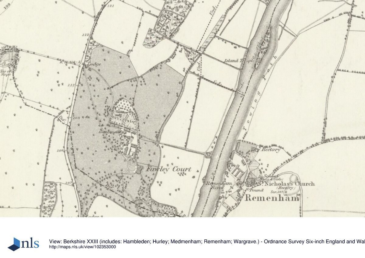
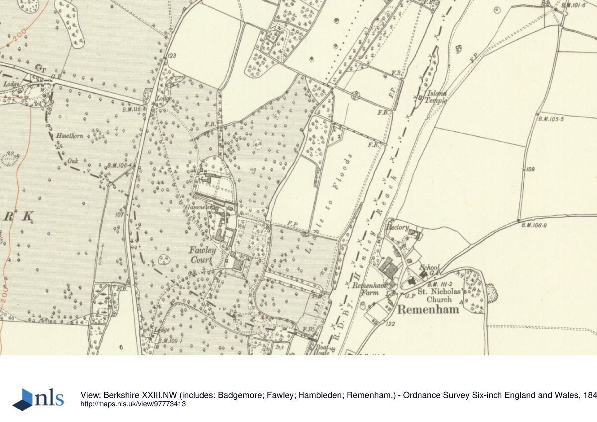
Fawley Court lies 2 kilometres north of Henley, in a valley of the Chiltern Hills through which the River Thames runs. The 65 hectare site lies on the drained flood plain of this valley, occupying the west bank of the Thames for 1.5 kilometres immediately north of Henley. Fawley is bounded on the east by the Thames, on the west by the A4155 Henley to Marlow road (an 18th century turnpike), on the south by Phyllis Court and to the north by water meadows and plantations. It is sited on flat land, slightly undulating in places.
The outer setting is the rim of the Chiltern Hills, mostly wooded hilltops and grazed or arable fields on the slopes below, and other parkland or grazed water meadow on the surrounding flat land. The market town of Henley sits at the southern end of the site andis important in distant views from Temple Island.
ENTRANCES AND APPROACHES
Fawley Court is approached by two curving drives, from north and south, running across the west park, called The Lawn, and probably dating from the 1770s. These drives run from the old turnpike (A4155), giving access from Marlow via the north drive and Henley via the south drive. North Lodge (about 1820, Listed Grade II), a white, rendered, classical, single-storey lodge lies at the head of the north drive, with iron gates and piers, and short lengths of railings on either side (about 1880, Listed Grade II). The north drive is flanked by several very large plane trees. A subsidiary drive also enters at North Lodge, curving 250 metres south-east to the kitchen garden. The south entrance is flanked by iron gates and piers set back about 50 metres from the road, the drive curving around the remains of a pleasure ground plantation to the east with late 20th century, single-storey residential buildings sited in much of it. The two main drives meet at the west front of the house, entering the rectangular gravel forecourt past a late 19th century stone balustrade (Listed Grade II) which separates the forecourt from the park. The drives connect in the park, immediately west of the balustrade. The north and south drives were laid out by 1824 (Bryant 1824) and are probably from the Brown period, about the 1770s. Temple Island is only reached by water.
PRINCIPAL BUILDING
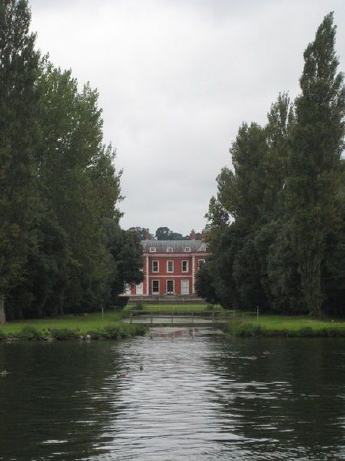
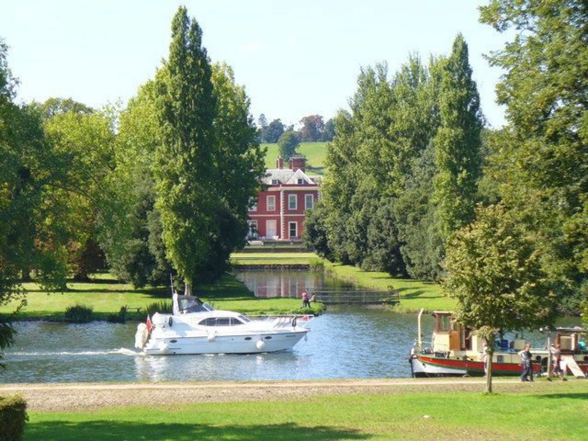
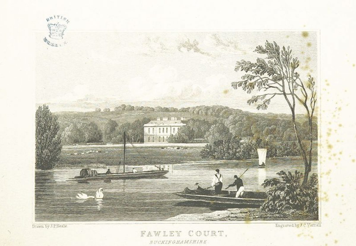
The H-plan house (1684, Listed Grade I) lies at the centre of the park and gardens, with good views of the site and its setting all round. Reputedly by Sir Christopher Wren, for Sir William Freeman, it is built of red brick with stone dressings. The interior was remodelled in the 1770s, with work by Sir James Wyatt (1747-1813). It is raised above ground level on two terraces, probably in order to minimise flooding, and linked on the north-west, by a quadrant, to an 1884 pavilion in matching style. The principal view, west, from the main west door and adjacent entrance court looks across parkland to No Man's Hill in neighbouring Henley Park; an expanse of open parkland with surrounding woodland. Views also extend from the other fronts of the house: east along the canal to the river, Remenham Farm and the low ridge beyond; north along the lime avenue across the north park to the distant wooded hillside and north-east to Temple Island (obscured, 1997; south along the plane avenue towards Phyllis Court.
The service yards north-west of the house link the house with the kitchen garden. Buildings include a brick menagerie with an apsidal north end (about 1770, Listed Grade II), now converted into stables, and the White Cottage (Listed Grade II), a single-storey house incorporating a small, late 18th century, octagonal pavilion, painted white.
GARDENS AND PLEASURE GROUNDS
The gardens lie to the north, south and east of the house. Two formal concentric terraces (Listed Grade II) flank the house to the south and east. The upper, stone-paved terrace may be a late 19th century reworking of a 1730s structure; the lower, grassed terrace is edged with paths, each terrace being edged with a stone balustrade (late 19th century, Listed Grade II). A large terrace flanks the north front at a lower level than the other two.
The wooded pleasure grounds south-east of the house are the main survival of the 1730s layout, although modified and extended in later phases. Several paths run through this area, the main one running south-east, turning east towards the river 100 metres from the house. The path is flanked by evergreen shrub plantings with mature trees and some yews, arriving at the flint temple (mid 18th century, Listed Grade II) some 150 metres south-east of the house. The ruined gothic façade disguises a domed grotto behind, designed to house John Freeman's collection of Arundel marbles (now (1997) in the Ashmolean Museum, Oxford). Continuing east for about 20 metres the path is straddled by the River Gate, a small, flint and stucco, covered bridge and gateway (mid 18th century, Listed Grade II), crossing a small stream or drainage ditch. The path continues east through the water meadows, crossing a small flint bridge to reach the edge of the river, where a boathouse stood in 1883 (Ordnance Survey 1st edition map published 1883).
The path south-east from the house divides before its east arm reaches the flint temple. The south arm encircles woodland south of the temple, adjacent to a clearing on the west edge of this woodland, with three mid-18th century stone ornaments on the east side of the clearing: an urn (Listed Grade II), a pedestal with lion's heads (Listed Grade II) and a sundial (Listed Grade II). A grass platform, the site of an oval glasshouse (Ordnance Survey 1883), lies at the north end of this area.
South of the house an open lawn is bounded at its south edge by a ha-ha, although the ha-ha wall has been removed. West of this lawn further woodland pleasure grounds contain ornamental trees and shrubs surrounding residential blocks and a 20th century church.
East of the house a flat lawn leads to a rectangular canal, about 1920, extending 100 metres towards the river, flanked by an avenue of holm oaks, and water meadows beyond this. North of the north terrace a late 19th ornamental plantation of cypresses frames a view north across the north park to the hills beyond. An important view north-east towards Temple Island is obscured (1997) by trees. An ornamental dairy (18th century, Listed Grade II) lies close to the north-west corner of the house, adjacent to the service yard, the east, flint-faced, two-storey, garden front resembling a Romanesque chapel, with a 12th century Norman doorway brought from a house in Henley.
The 18th century temple and bridge are an important survival from about the 1730s when John Freeman was friends with Edmund Waller, of Hall Barn near Beaconsfield, the stepson of John Aislabie who designed Studley Royal, Yorkshire, and assisted Waller when planning Hall Barn gardens. Aislabie and Waller may well have offered advice to Freeman on laying out his garden. Several other contemporary garden features are thought to have existed close to the house (Records of Bucks 24).
PARK
The park surrounds the house and pleasure grounds. Created from drained flood meadow, it is now pasture. West of the house The Lawn has scattered 19th and 20th century trees, and some 18th century trees, including at least six London planes of great size. The 18th century planting on The Lawn was simple and open in order not to obstruct views between the house and Henley Park. The Marlow road is partially concealed by a low, crude earth bank on the west boundary of The Lawn, with several large trees growing on it, including a large London plane. The bank may be from the Brown period.
The north park, north of the walled garden, contains late 19th century planting including a lime avenue on an axis with the north front of the house. A series of open 19th century drains, about 10 metres wide, are visible in the north-east section. The south park does not seem to have been part of the park until the late 19th century when the avenue of formally planted clumps of London plane was established (Ordnance Survey 1883). Views of the river from the north and south parks have been partly obscured by woody growth on the water meadows. In 1824 a long inlet from the river called the New River ran in a straight arm west from just south of Temple Island, turning south to continue more or less straight towards the house, but stopping some way short of it (Bryant 1824).
KITCHEN GARDEN
The 0.5 hectare kitchen garden lies in parkland 100 metres north-west of the house, separated by service yards and buildings. The bottom half of the walls is of flint, and the top brick. None of the interior structure survives, and it now houses a garden centre. The adjacent ground is used for storage and car parking.
OTHER LAND
Water meadows divide the park from the river. The brush and young plantations growing here restrict views to and from the site and the river, especially those including Temple Island.
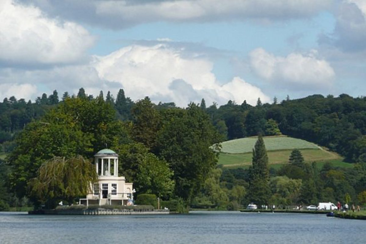
Temple Island is a natural island in the middle of the river 300 metres north-east of the house, standing at the head of a straight 2 kilometre stretch of the river from Henley and used as a vantage point during the Henley rowing regatta. Sambrooke Freeman commissioned the only building, the Fishing Temple (James Wyatt 1771, Listed Grade II), which lies at the southern end of the island and is surrounded by lawn. Woodland growing on the northern half of the island frames the pale, stuccoed temple which sits at the north-east end of Brown's principal vista from the north front of the house, and is also prominent outside the site. The south-facing building consists of a shallow bow front and balcony with a 19th century cottage behind, and an open cupola with columns enclosing a statue (about 1770) of Bacchante (replacing the original 18th century statue of Venus). The interior has the earliest known Etruscan decorative scheme in England. The temple was a summerhouse for excursions from the house, as well as an eyecatcher from the house and pleasure grounds and various other viewpoints including land east of the river and Remenham Lane, the river and its banks south of the island, and the distant view from Henley Bridge. Henley parish church tower is important, terminating the view south from the temple.
REFERENCES
Records of Bucks 24, (1982), pp 130-43
Country Life, no 16 (20 April 1989), pp 214(20; no 27 (4 July 1991), pp 112-13
Fawley Temple, guidebook, (1994)
N Pevsner and E Williamson, The Buildings of England: Buckinghamshire (1994), pp 390-2
Maps
Bryant, Map of Buckinghamshire, 1824
OS 6" to 1 mile: 1st edition published 1883
2nd edition published 1900
3rd edition revised 1938
OS 25" to 1 mile: 1st edition published 1881/2
2nd edition published 1898
Description written: 1997
Amended: April 1999
Edited: June 1999
- Visitor Access, Directions & Contacts
Directions
Outside Henley-on-Thames on the A4155
Owners
The Congregation of Marian Fathers
- History
The following is from the Register of Parks and Gardens of Special Historic Interest. For the most up-to-date Register entry, please visit the The National Heritage List for England (NHLE):
www.historicengland.org.uk/listing/the-list
HISTORIC DEVELOPMENT
The Freemans bought the estate in the early 1680s. A new house, possibly designed by Christopher Wren (1632-1723), was built by William Freeman on the site of the old manor house. In 1707 William's nephew John Freeman succeeded. During the 1730s he created the pleasure grounds which included several important garden buildings, and may have received advice from Edmund Waller (owner of Hall Barn, Beaconsfield, qv) and John Aislabie (owner of Studley Royal, North Yorkshire, qv) (Records of Bucks 24).
John Freeman died in 1752. His son, Sambrooke, continued to develop Fawley. He was a member of the Society of Dilettanti, and was probably in frequent contact with Sir Francis Dashwood at West Wycombe (qv). Sambrooke enlarged the estate considerably, including in the 1760s buying the manors of Remenham, east of the river, and Phyllis Court and Henley Park south and west of Fawley respectively. He remodelled the house and carried out major alterations to the grounds in the 1770s, employing Lancelot Brown (1716-83). Strickland Freeman, Sambrooke's nephew, inherited the estate in 1782 and became an 'improving' landlord until his death in 1821, building many estate structures. In 1853 the estate was sold to Edward Mackenzie whose son William carried out major alterations to house and grounds at the end of the C19. The house held a military intelligence school during the Second World War, and was bought by the Marian Fathers from Miss Mackenzie after the war. The estate is now (1997) in divided ownership.
- Associated People
- Features & Designations
Designations
The National Heritage List for England: Register of Parks and Gardens
- Reference: GD1353
- Grade: II*
Features
- Terrace
- Description: Two formal concentric terraces (Listed Grade II) flank the house to the south and east.
- Lawn
- Topiary
- Religious House (featured building)
- Description: The H-plan house was reputedly by Sir Christopher Wren, for Sir William Freeman. It is built of red brick with stone dressings. The interior was remodelled in the 1770s, with work by Sir James Wyatt.
- Earliest Date:
- Latest Date:
- Temple
- Description: The 1771 Fishing Temple stands on Temple Island in the River Thames, in Brown's principal vista.
- Earliest Date:
- Latest Date:
- Drive
- Description: Fawley Court is approached by two curving drives. The north and south drives were laid out by 1824 (Bryant 1824) and are probably from the Brown period, about the 1770s.
- Latest Date:
- Gate Lodge
- Description: North Lodge, a white, rendered, classical, single-storey lodge lies at the head of the north drive, with iron gates and piers, and short lengths of railings on either side.
- Earliest Date:
- Latest Date:
- Balustrade
- Description: Late 19th century stone balustrade (Listed Grade II) which separates the forecourt from the park.
- Earliest Date:
- Latest Date:
- Stable
- Description: Brick menagerie with an apsidal north end (about 1770, Listed Grade II), now converted into stables.
- Earliest Date:
- Latest Date:
- Garden Building
- Description: White Cottage (Listed Grade II), a single-storey house incorporating a small, late 18th century, octagonal pavilion, painted white.
- Path
- Description: Several paths run through the wooded pleasure grounds.
- Ornamental Bridge
- Description: The River Gate, a small, flint and stucco, covered bridge and gateway (mid 18th century, Listed Grade II), crossing a small stream or drainage ditch.
- Earliest Date:
- Latest Date:
- Urn
- Pedestal
- Description: A pedestal with lion's heads.
- Sundial
- Ha-ha
- Description: South of the house an open lawn is bounded at its south edge by a ha-ha, although the ha-ha wall has been removed.
- Canal
- Description: East of the house a flat lawn leads to a rectangular canal, about 1920, extending 100 metres towards the river.
- Earliest Date:
- Latest Date:
- Avenue
- Description: Avenue of holm oaks.
- Plantation
- Description: A late 19th ornamental plantation of cypresses.
- Earliest Date:
- Latest Date:
- Dairy
- Description: An ornamental dairy (18th century, Listed Grade II) lies close to the north-west corner of the house.
- Earliest Date:
- Latest Date:
- Kitchen Garden
- Description: The bottom half of the walls is of flint, and the top brick. None of the interior structure survives, and it now houses a garden centre.
- River
- Key Information
Type
Park
Purpose
Ornamental
Principal Building
Religious Ritual And Funerary
Survival
Extant
Hectares
65
Open to the public
Yes
Civil Parish
Remenham
- References
References
- {English Heritage Register of Parks and Gardens of Special Historic Interest} (Swindon: English Heritage 2008) [on CD-ROM] Historic England Register of Parks and Gardens of Special Historic Interest
- Related Documents
-
CLS 1/1070
The Folly and the Mausoleum - Hard Copy
Geoffrey Tyack, Country Life 20 April 1989 - 1989
-
CLS 1/1071
JL Phibbs, C Gallagher, D Lambert - 1990
-
CLS 1/1070