Introduction
Elvaston Castle has a landscape park, woodland and formal gardens. The site, which occupies about 80 hectares, also has a local nature reserve.
Terrain
The site is on level land within the flood plain of the River Derwent.
The following is from the Register of Parks and Gardens of Special Historic Interest. For the most up-to-date Register entry, please visit the The National Heritage List for England (NHLE):
www.historicengland.org.uk/listing/the-list
Formal gardens and pleasure grounds laid out 1830-51 by William Barron for the fourth Earl of Harrington. The gardens were created using many mature trees which were transplanted by methods pioneered by Barron's mentor at the Edinburgh Botanic Gardens, William McNab, and developed by Barron.
DESCRIPTION
LOCATION, AREA, BOUNDARIES, LANDFORM, SETTING
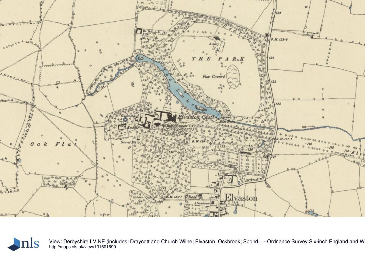
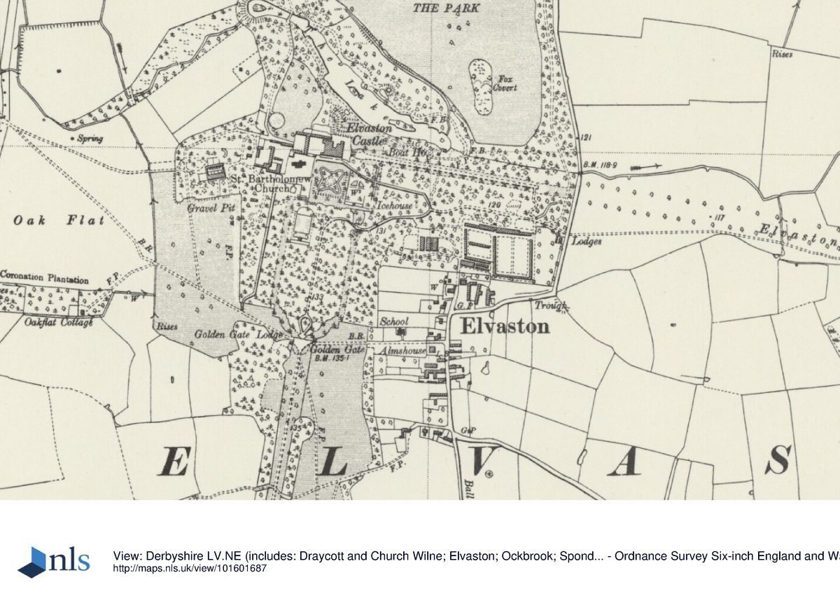
Elvaston Castle is situated c 6km south-east of Derby city centre, immediately north and west of the village of Elvaston in an area of rural and suburban character. The c 80ha site is on level land within the flood plain of the River Derwent. The boundaries are fenced with the exception of Elvaston Avenue which runs across open fields.
ENTRANCES AND APPROACHES
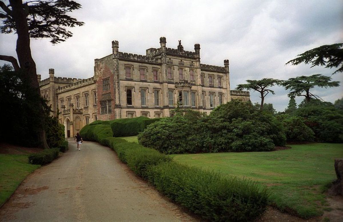
The principal entrance was London Road Lodge (early C19, listed grade II) which has lodges linked by a crenellated wall with a central gateway. This entrance is at the southern end of the site on the A6 from which a drive, now a path planted (C20) as an avenue of horse chestnuts, runs north to a set of gates called the Golden Gate (listed grade II) which are flanked by piers of alabaster. The ornate ironwork gates were purchased by the third Earl of Harrington in 1819 and are thought to come from Paris (Colston Stone 1992). A path leads from them northwards to the Castle. This approach is on the line of an avenue shown on an undated map prepared for the third Earl of Harrington (and therefore made during the years 1760(79) by G Grey. The avenue was planted or replanted by Barron during the 1830s. Another entrance on the east side of the site in Elvaston leads to a drive running westwards past the Golden Gate before turning northwards and then eastwards to the stable yard. A lodge (listed grade II) is positioned beside the drive at the entrance to the yard. An entrance with a lodge called Drive Lodge lies on the east side of the site on the B5010 and a drive from it leads to the kitchen garden and paths leading westwards through the site to the Castle. A drive leads from Home Farm (outside the registered area) on the north-west side of the site and joins with Bedford Drive (see below) and with paths leading south to the stable yard. The main visitor entrance created late C20 is c 320m north of Drive Lodge where a turning leads into a car park on the east side of the site.
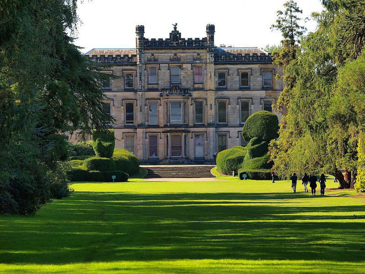
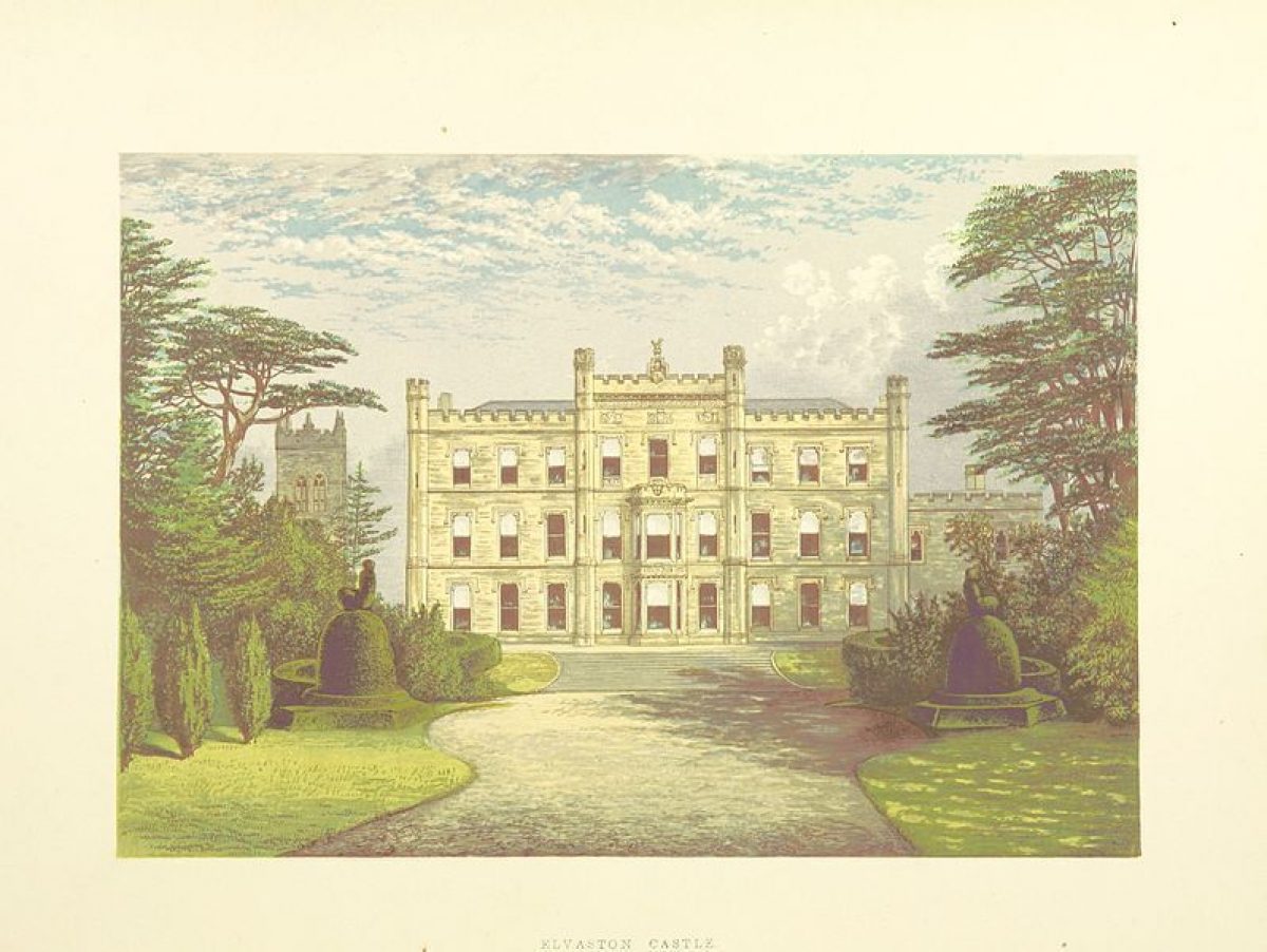
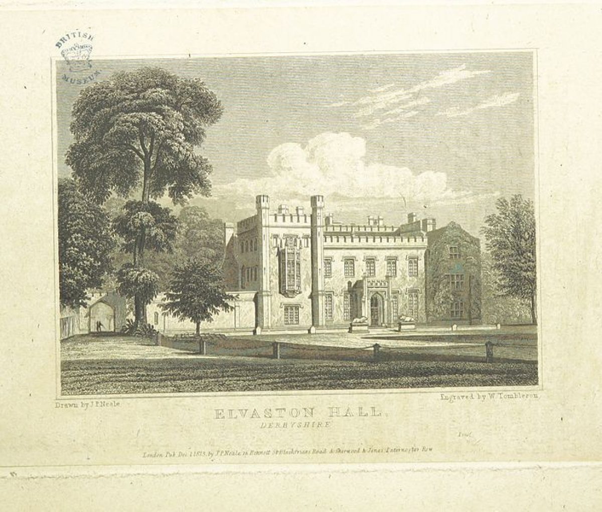
PRINCIPAL BUILDING
Elvaston Castle (listed grade II*) was built in 1633 and altered during the early C18. A major remodelling to designs by James Wyatt (1747-1813) took place c 1817 in castellated Gothick style. Alterations of 1830 to 1840 were by L N Cottingham.
There are two courtyards with buildings ranged around them to the west of the Castle. Immediately to the west an arcaded shelter of 1970 runs along the north side of the courtyard, with the walls of St Bartholomew's churchyard (listed grade II) on the south side. The westernmost courtyard has a coach house and attached ancillary buildings and stables (all listed grade II) ranged around the courtyard. Immediately south-west of this there are a number of farm buildings in use as a riding school and museum (1998), including an early C19 stable block (listed grade II) and mid C19 farm buildings (listed grade II) which are ranged around a farmyard.
St Bartholomew's church (listed grade I) lies in a churchyard c 50m south-west of the Castle. It has C13 origins with later additions and alterations including an extension to the chancel of 1904 by G F Bodley. The churchyard contains the Harrington family mausoleum.
GARDENS AND PLEASURE GROUNDS
The gardens consist of formal gardens to the south and south-east of the Castle, and less formal grounds with woodland and a lake to the north and north-east.
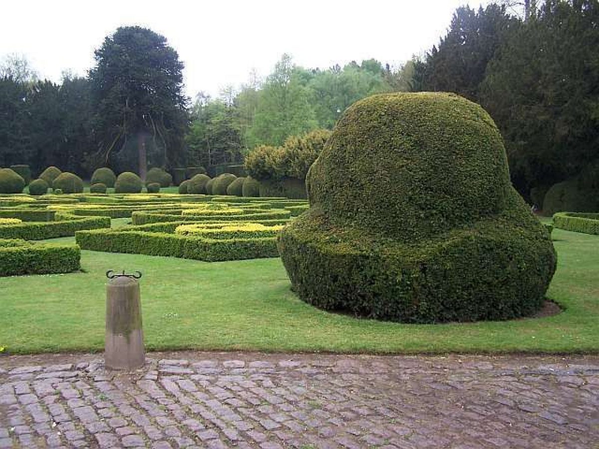
Immediately south of the Castle the Parterre Garden has a formal layout with clipped yew bushes and quartering paths between geometrical beds lined with clipped box. On each side clipped and topiaried Irish and common yews frame the Garden and conceal terraced walks which run north/south on the east and west sides of the Garden. The parterre was created in 1970 on the site of a formal garden called Mon Plaisir. This had a covered walk in the form of an exaggerated quatrefoil formed from clipped arbor vitae hedges with loopholes to give light and entrances cut through the hedges. A central mound was laid out with a star-shaped flower bed and had a single central Araucaria, one of dozens introduced to the garden by Barron. It is shown in a bird's-eye view of c 1856 by E Adveno Brooke, and in less complete form in an aerial photograph of 1954 (both reproduced in GAA 1997). William Barron (1800(91) based the garden on a C17 design by Daniel Marot, and it was probably laid out to evoke a medieval garden in keeping with the romantic interests of the fourth Earl.
Steps lead up at the south end of the Garden to an opening formed between yews clipped into the shape of a crown. From this a path leads westwards to the Alhambra Garden, a grassed rectangle bordered by golden yews and birches overlooked from the south end by the Moorish Temple (listed grade II). Adveno Brooke's c 1856 illustration shows that it was laid out with low clipped hedges and formal flower beds. C19 accounts state that it was enclosed by hedges of Portuguese laurel and yew. The style is termed as Oriental Scroll style and raised circular beds are described. In the centre of the Garden there was a golden yew in a raised bed surrounded with architectural edgings of stone or tile. The Garden layout was removed in the mid C20.
Immediately east of the Parterre Garden and divided from it by clipped hedges is the Italianate Garden. This occupies a rectangular grassed area bordered by tall yew hedges with clipped hedges and simple topiary shapes cut into Irish yew bushes in the southern part of the Garden. The Garden was known as the Garden of the Fairstar and had an ironwork Moorish bower at the north end overlooking a crescent-shaped bank planted with cedars and yews. Scroll-shaped flower beds lay to the south of the crescent and topiary yews and junipers occupied the southernmost part of the Garden. This arrangement is shown in an illustration by Adveno Brooke of c 1856 and on the 1881 OS map, but it fell into disrepair and the bower was removed, probably in the mid C20.
The southern part of the garden, south of the formal gardens, is laid out with three parallel avenues cut through evergreen and coniferous trees. The central avenue, called Vault Avenue, is on the line of the carriage drive from London Road Lodge and the Golden Gate entrance. A substantial ha-ha and stone wall (listed grade II with the Gate) run on each side of the Gate separating the pleasure grounds from the park. To the west Church Avenue is aligned with St Bartholomew's church and terminates at the north end with a topiary feature called the Bird Cottage. The avenue to the east is called School Avenue. This area contains a wide variety of evergreen trees which represent what survives from an extensive collection arranged in plant groups by Barron.
On the east side stone steps lead down from a terrace in front of the Castle. Topiary yews are positioned at the base of the steps and lead on to the Elvaston Avenue, much as shown in a late C19 view by F O Morris. A bank and ha-ha conceal the B5010 so that an uninterrupted view can be obtained along the Avenue from the Castle. This area is shown with formal gardens and an avenue on the Grey map although it was comprehensively replanted by Barron.
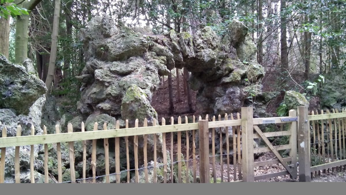
On the north side of the Castle grassed lawns are terraced down to the edge of a lake. Late C20 concrete steps have been placed at various points to facilitate descent to the shore of the lake. Some 60m north-east of the Castle the remains of a water feature with stone foundations are all that survives of a fountain and rockwork grotto shown in C19 views (GAA 1997). A number of mature cedars on the lakeside are the remains of Barron's planting scheme and some can be identified with individual trees shown on mid and late C19 prints and photographs (ibid). Paths lead around the lake perimeter to a viewing point c 120m north of the Castle where a rockwork arch on the lake's edge frames views across the water. The north side of the lake is wooded and some of the trees are probably those planted as mature specimens by Barron. There are extensive areas of rockwork all along the northern side of the lake, and c 200m north-east of the Castle a large rockwork structure (listed grade II) built to represent a ruined castle is flanked by rustic arcading. This cuts into a mound originally surmounted by a spiral path and dense planting, from which views southwards over the lake to the Castle can be obtained. The northern shore of the lake was also set out with earthworks in the form of fortifications for the ruined castle, and a serpentine path, which continues around the lake and returns along its southern shore. A boathouse (mid C19, listed grade II) lies on the water's edge c 200m east of the Castle.
PARK
North of the lake The Park is separated from the woodland around the lake by a fence. The area is open grassland protected by a belt of trees through which a ride called Bedford Drive runs. This was described by J C Loudon as 'having recently been formed' in 1839 (Boniface 1987). Barron used the planting around The Park as a reserve ground for conifers where they were brought on before being planted in their final positions.
The Elvaston Avenue, aligned with the east side of the Castle, extends across arable land for a distance of c 1.3km. It is on the line of an avenue shown on the Grey map. J C Loudon describes 'fine old avenues' in 1839 (ibid), suggesting that some C18 planting survived at that time. It was probably augmented and replanted by Barron, who cleared away all trees and hedgerows in the line of the Avenue for a distance of c 10km so that uninterrupted views could be obtained along it.
On the south side of the Castle the avenue from London Road Lodge is flanked by woodland and areas of open grassland. South-west of the Castle there is a cricket ground and open grassland divided from agricultural land by a fence.
KITCHEN GARDEN
The kitchen garden lies c 400m south-east of the Castle and consists of a sub-rectangular brick-walled enclosure (walls listed grade II) divided into two unequal parts by a brick wall. The area to the west has been planted as a flower garden in the late C20. The area to the east contains the remains of glasshouses along the inner north wall. A range of ancillary buildings is built along the outer northern wall.
REFERENCES
F O Morris, A Series of Picturesque Views 2, (1866-80) [reproduced in GAA]
EA Brooke, The Gardens of England (1857), pls 15-17 [reproduced in GAA]
Gardeners' Chronicle, (23 December 1876), p 807; (30 December 1876), p 838
N Pevsner and E Williamson, The Buildings of England: Derbyshire (2nd edn 1978), pp 210-11
G and S Jellicoe et al, The Oxford Companion to Gardens (1986), p 161
B Elliott, Victorian Gardens (1986), pp 8-7
P Boniface (ed), In search of English Gardens: the Travels of John Claudius Loudon and his wife Jane (1987), pp 182-8
Elvaston Castle Pilot Restoration Plan, (Colston Stone Partnership 1992)
Elvaston Castle Historical Analysis and Restoration Proposals, (Glenn Anderson Associates (GAA 1997)
Maps
G Grey, A Map of the Parish of Elvaston..., nd (prepared between 1760-79) [in GAA 1997]
Plan of the Parish of Elvaston, 1852 [in Colston Stone 1992]
OS 25" to 1 mile: 1st edition published 1881
OS 1" to 1 mile: 1st edition published 1836
Archival items
Archival sources are listed in the GAA (1997) and Colston Stone Partnership (1992) studies.
Description written: September 1998 Amended: March 1999; May 1999
Register Inspector: CEH
Edited: November 1999
- Visitor Access, Directions & Contacts
Telephone
01629 533870Access contact details
The grounds are open daily, 9am to dusk.
For more detailed information visit the Elvaston Castle Country Park website.
Owners
Derbyshire County Council
- History
The following is from the Register of Parks and Gardens of Special Historic Interest. For the most up-to-date Register entry, please visit the The National Heritage List for England (NHLE):
www.historicengland.org.uk/listing/the-list
HISTORIC DEVELOPMENT
The estate was owned by Walter Blount, created Lord Mountjoy in 1465, during the C15 and it passed to Sir Michael Stanhope in the C16. It remained in the Stanhope family who were created earls of Harrington in 1742. The second Earl made Elvaston his principal seat in the later C18. The fourth Earl has been described as 'a renowned eccentric and dandy' (Glenn Anderson Associates 1997) and following his marriage to actress Maria Foote in 1831 and the scandalised reaction of polite society, he withdrew from public life and concentrated on developing the Castle and grounds at Elvaston. The Earl's interest in romantic medievalism and chivalric themes influenced the layout of the gardens which were closed to the public until his death in 1851 but became well known during the C19 through articles in gardening journals and writers such as E Adveno Brooke.
The Stanhope family continued to live at Elvaston until the eleventh Earl moved to Ireland in 1939. The site was let and subsequently sold to a development company in 1963. In 1969 it was acquired by Derbyshire County Council and opened as a Country Park in 1970, in which use it remains (1998).
Period
- Post Medieval (1540 to 1901)
- Victorian (1837-1901)
- Associated People
- Features & Designations
Designations
The National Heritage List for England: Register of Parks and Gardens
- Reference: GD1368
- Grade: II*
Local Nature Reserve
Features
- Topiary
- Avenue
- Parkland
- Woodland
- Key Information
Type
Park
Purpose
Ornamental
Principal Building
Domestic / Residential
Period
Post Medieval (1540 to 1901)
Survival
Extant
Hectares
80
Open to the public
Yes
Civil Parish
Elvaston
- References
References
- {English Heritage Register of Parks and Gardens of Special Historic Interest} (Swindon: English Heritage 2008) [on CD-ROM] Historic England Register of Parks and Gardens of Special Historic Interest
- Elliott, B {Victorian Gardens} (1986) pp 83-87 Victorian Gardens
- Pevsner, N and Williamson, E {The Buildings of England: Derbyshire} (Harmondsworth: Penguin, 1978) pp 210-211 The Buildings of England: Derbyshire
- Related Documents
-
CLS 1/985/1
Restoration and Management Plan for the Historic Gardens and Park, Vol.1 Survey and Analysis - Hard Copy
Parklands Consortium Ltd - 1999
-
CLS 1/985/2
Restoration and Management Plan for the Historic Gardens and Park, Vol.2 Recommendations - Hard Copy
Parklands Consortium Ltd - 1999
-
CLS 1/985/3
Appendices: 1.Trees, 2.Buildings Condition,3.Rockwork,4.Lake Condition - Hard Copy
Parklands Consortium Ltd - 1999
-
CLS 1/985/10
Conservation Plan, Vol.1 - Hard Copy
Hilary Taylor Landscape Associates Ltd - 2004
-
CLS 1/985/11
Conservation Plan Vol.2 Appendices - Hard Copy
Hilary Taylor Landscape Associates Ltd - 2004
-
CLS 1/985/4
Conservation Management Plan, Vol.1 Sections 1-8 - Hard Copy
Hilary Taylor Landscape Associates Ltd - 2006
-
CLS 1/985/5
Conservation Management Plan, Vol.2 Sections 9-12 - Hard Copy
Hilary Taylor Landscape Associates Ltd - 2006
-
CLS 1/985/6
Conservation Management Plan, Vol.3 Appendices - Hard Copy
Hilary Taylor Landscape Associates Ltd - 2006
-
CLS 1/985/7
Conservation Management Plan, Vol.3 Appendices Pt. 2 - Hard Copy
Hilary Taylor Landscape Associates Ltd - 2006
-
CLS 1/985/8
Conservation Management Plan, Vol.4 Supplementary Documents - Hard Copy
Hilary Taylor Landscape Associates Ltd - 2006
-
CLS 1/985/9
Conservation Plan - Hard Copy
Hilary Taylor Landscape Associates Ltd - 2003
-
CLS 1/985/1