Introduction
The present form of the grounds around the 17th-century castle dates from the late-18th and early-19th centuries and includes a distinctive beech avenue in the parkland. Further planting, in particular an arboretum of ornamental conifers, was added at the end of the 19th century. A kitchen garden associated with the Mains has ornamental and productive plantings.
http://portal.historic-scotland.gov.uk/hes/web/f?p=PORTAL:DESIGNATIONS:0
Type of Site
No information available.
Location and Setting
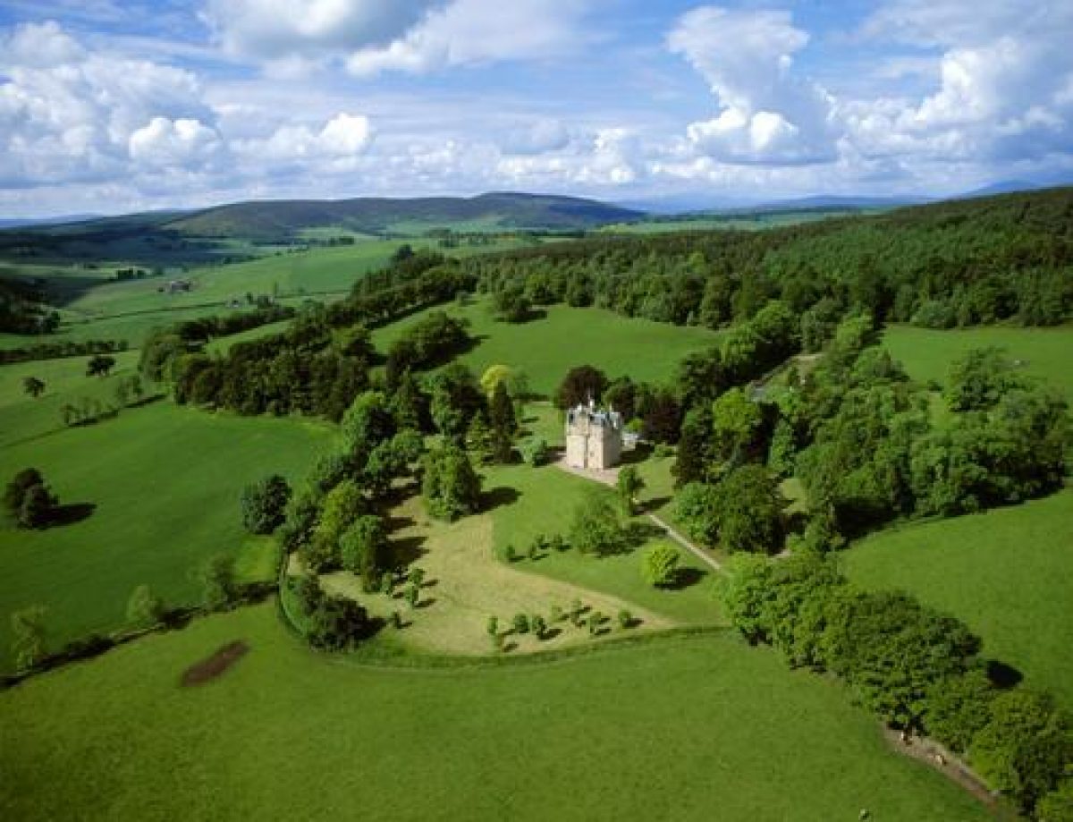
Craigievar Castle is situated in the foothills of the Grampian Mountains on the eastern slopes of the Hill of Craigievar overlooking the valley of the Water of Leochel. The policies are bordered along the east side by the A980 Banchory to Alford road, and on the south side by the Rumblie Burn. The Rumblie Burn and the Corse Burn converge at the south-east corner of the policies and form the Leochel Burn which runs north into the River Don at the Bridge of Alford.
The surrounding valleys are mainly used for agriculture, particularly livestock grazing, and open moorland covers most of the hilltops. There are extensive views north-east across the Corrennie Moor to the Pitfichie Forest and Bennachie, 1,732' (528m), and long views south-east to the Grampians. The Castle tower lies in the lee of Craigievar Hill and it dominates the valley of the Leochel Burn. There are superb glimpses of it and the policies in which it stands from the A980.
Craigievar Castle is set on the western side of its policies which extend over some 547 acres (221ha) along the valley of the Leochel Burn. To the west, these are surrounded by extensive conifer woodlands planted on Craigievar Hill. To the north-east a small woodland strip provides shelter for the parkland surrounding the Castle. Documentary evidence of the development of the designed landscape is provided by several sources. These include an early survey plan of c.1776 by George Brown which shows the remnants of a formal landscape around the Castle and a large rectangular enclosed garden. There are also accounts for some work dated 1776. Another survey in 1791 shows some of the changes in the late 18th century but it was in the early 19th century that the greatest changes took place. These can be seen on an 1840 survey and in the 1st edition OS plan of 1874. In the second half of the 19th century, more changes were made to the field patterns, kitchen garden and the small park, indicating that there was considerable activity in the garden. Most of the conifers were probably planted at this time.
Landscape Components
Architectural Features
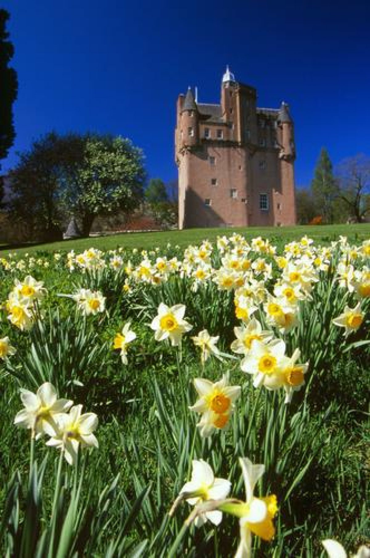
Craigievar Castle is a six-storey L-plan Tower House renowned for being one of the finest original examples of Scottish Baronial architecture; it is listed category A. It was begun by the Mortimers and completed in 1626 by William Forbes who is thought to have used John Bell as mason. It was re- roofed in 1824 by John Smith of Aberdeen. Some repairs and reharling were carried out in 1973 by the National Trust for Scotland.
The Mains is listed category B and is a late 18th century two-storey block with a date stone of 1776 over the door. The Coach-house, now known as The Steading, is also listed category B as part of the grouping, is of the same age; it was converted into a dwelling in 1964. Other buildings include a Bothy, in the kitchen garden, and a Cottage with a mid- 19th century kennel nearby.
Parkland
The parkland surrounds the Castle and immediate gardens and arboretum on all sides. It is largely 'improved pasture' which was, in the 19th century, broken up by lines of trees as shown on the 1st edition OS of c.1860. These tree lines followed the contours of the valley on which the parks are laid out. The original drive to the south is bordered by a magnificent avenue of beech planted c.1800; this is now used as a farm track.
The north drive provides an access to the Castle off the A980. In the 19th century, it too was lined with trees where it passed through the parkland. The original trees have since been felled but the roadside has recently been replanted.
Woodland
The woodland blocks are predominantly conifers replanted within the last fifty years. Some small copses and shelterbelt plantations, particularly along the A980, are planted with hardwoods, mainly beech and sycamore, and date from the 1880s.
Walled Garden
There are two kitchen gardens at Craigievar. The original garden was sited to the west of the Castle; now marked by the remnants of a beech hedge, it has been grassed over.
The Victorian kitchen garden, also bordered by a hedge, is sited up the hill to the west of the Mains and is now used by staff of the Castle. Low box hedges divide the garden into small areas which now grow fruit, a few vegetables and some flowers. Until recently it was used to supply fruit and vegetables for the Castle. To the north of this garden is a small derelict rockery planted in the 1930s. Ornamental Japanese maples, bamboos, some rhododendrons and other shrubs still grow there, although rather overgrown.
Arboretum
To the west of the Castle is the barmkin wall. Beyond it, and to the north of the Castle, terraces have been cut out of an east-facing slope. The flat areas formed suggest the site of gardens but there is no documentary evidence to confirm this.
The arboretum was established in the late 19th century on the lawns around the Castle. Many specimen trees remain today, serving to greatly enhance the Castle setting. Thirteen of the trees were measured by Alan Mitchell in 1983. They include two large silver firs, one over 140 ft high, a tall Monkey puzzle, and four Wellingtonias, the tallest over 124 ft. Some recent planting, including a weeping horse chestnut, will soon hide the magnificent views to the north-east.
- Visitor Access, Directions & Contacts
Telephone
01339 883635Access contact details
The grounds are open daily all year. The castle is open on varying days between April and September.
Directions
Craigievar Castle is on the A980 6 miles south of Alford.
Owners
The National Trust for Scotland
- History
The following is from the Historic Environment Scotland Gardens and Designed Landscapes Inventory. For the most up-to-date Inventory entry, please visit the Historic Environment Scotland website:
http://portal.historic-scotland.gov.uk/hes/web/f?p=PORTAL:DESIGNATIONS:0
Reason for Inclusion
The parkland and castle together make an outstanding contribution to the scenery of the Grampian foothills between Banchory and Alford.
Main Phases of Landscape Development
No information available.
Site History
Little remains of the 17th century designed landscape and the grounds around the Castle date from the late 18th & early 19th centuries. Further planting, particularly of ornamental conifers, was added at the end of the 19th century. In the 1930s a rock garden was created behind the coach-house and, more recently, flower borders were added around the Castle and in the kitchen garden.
The Craigievar lands were held by the Mortimer family from 1457. The Castle was begun in the early part of the 17th century. However, in 1610 William Forbes of Menie bought the property and unfinished Castle. A year before William's death in 1627, the Castle was completed and has remained more or less unaltered ever since. His son William was created a Baronet of Nova Scotia. Craigievar was used to house and protect his valuable objects such as grain and stores. It seems unlikely that any early 17th century garden survived through this turbulent period.
The 5th Baronet, Sir William, married Sarah, daughter of the 13th Lord Sempill, and it was their grandson William, 8th Baronet, who inherited in 1884 the title of 17th Lord Sempill. During the 5th Baronet's tenure, George Brown was commissioned to survey the policies and some planting took place to create a more 'informal' landscape. Sir John, 7th Baronet, re-roofed the castle and undertook some alterations to the grounds. His son William, 8th Baronet and 17th Lord Sempill, established the arboretum.
In 1934 William, 10th Baronet and 19th Lord Sempill, inherited from his father. In 1963, assisted by a 'consortium of benefactors', the National Trust for Scotland was able to acquire the Castle and its immediate policies in order that it could be preserved. The family are still closely involved with the Castle and its grounds.
Period
- 18th Century (1701 to 1800)
- Late 18th Century (1767 to 1800)
- Associated People
- Features & Designations
Designations
Historic Environment Scotland An Inventory of Gardens and Designed Landscapes in Scotland
Features
- Avenue
- Description: A beech avenue planted along the former main drive.
- Earliest Date:
- Latest Date:
- Rockery
- Description: A rockery with a Japanese theme, which is now overgrown.
- Earliest Date:
- Latest Date:
- Castle (featured building)
- Description: Re-roofing and repairs were carried out in the 19th and 20th centuries.
- Earliest Date:
- Latest Date:
- Key Information
Type
Estate
Purpose
Ornamental
Principal Building
Domestic / Residential
Period
18th Century (1701 to 1800)
Survival
Extant
Hectares
209.9
Open to the public
Yes
- References
References
-
Historic Scotland, 'Craigievar Castle', {Gardens and Designed Landscapes},
Contributors
Historic Scotland
-
Historic Scotland, 'Craigievar Castle', {Gardens and Designed Landscapes},