Introduction
The present grounds include the remnants of an 18th-century landscape park and a 19th-century terraced garden. At its most extensive the park covered about 160 hectares, but only about 40 hectares remain.
Terrain
The house and park to the north lie on a plateau at the top of a south-east-facing slope.The following is from the Register of Parks and Gardens of Special Historic Interest. For the most up-to-date Register entry, please visit The National Heritage List for England (NHLE):
A country house with the remains of an early C18 formal garden by Stephen Switzer flanking mid C19 formal terraces, surrounded by the remains of a landscape park laid out in the 1760s by Lancelot Brown.
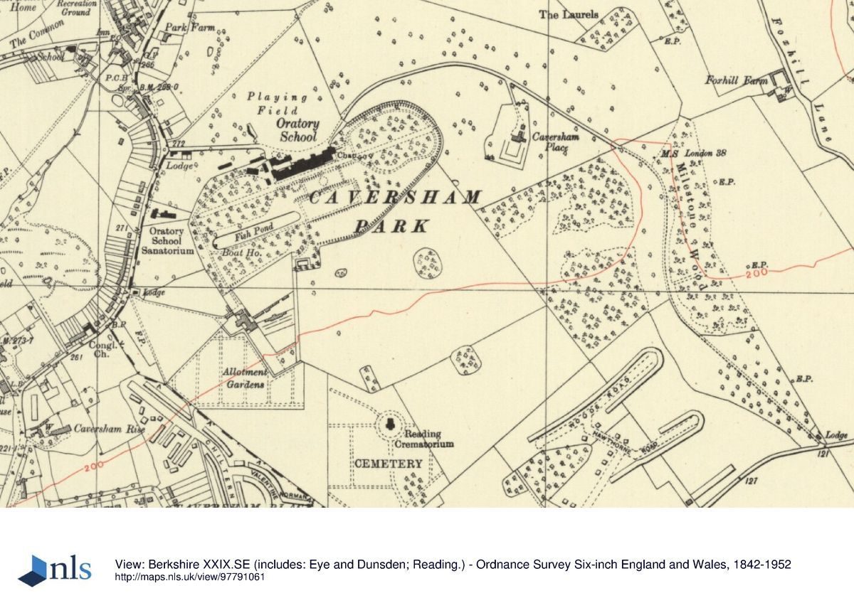
Location, Area, Boundaries, Landform and Setting
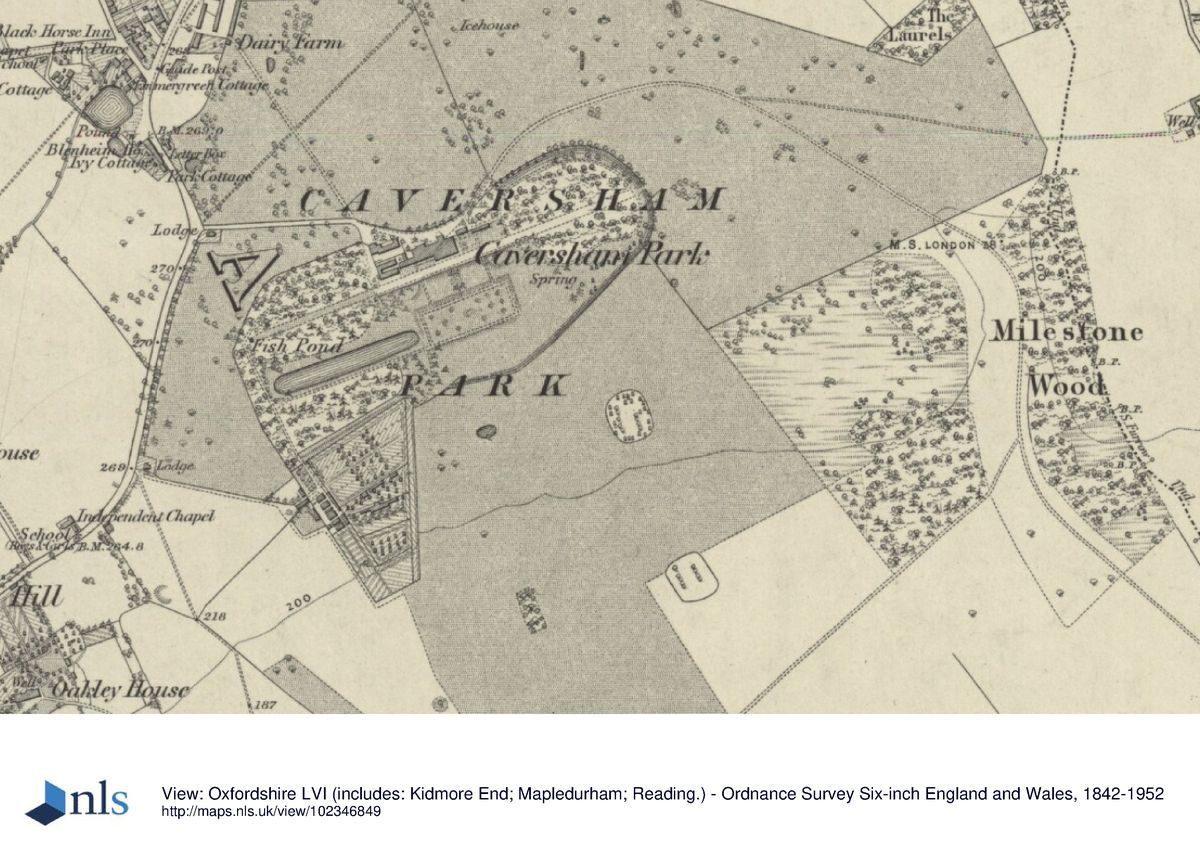
Caversham Park lies enclosed by the C20 development of Caversham, once a separate village but now a suburb of Reading. The c 40ha site is bounded largely by the mid to late C20 development of Caversham Park Village, with to the south the open spaces of allotments and Reading Cemetery and Crematorium. The house and park to the north lie on a plateau at the top of a south-east-facing slope. Panoramic views extend southwards from the house and garden terraces at the top of the slope across Caversham and Reading, towards low, distant hills, probably formerly with views of the Thames which lies 2km to the south.
Entrances and Approaches
Caversham Park is entered at the north-west corner of the park, off Peppard Road, 250m west of the house. Here the drive is flanked by two stone gate piers, topped with ball finials, supporting iron gates, in turn flanked by iron pedestrian gates and beyond this iron railings terminated by a further pair of stone piers (c 1850, listed grade II). The drive passes a single-storey lodge standing adjacent to the south, continuing east through the park and passing to the north of the stuccoed former stables (now converted to accommodation) standing close to the west end of the house. The drive arrives at a tarmac carriage sweep adjacent to a porte-cochère on the north front of the house, overlooking the north park which is now maintained as playing fields.
Formerly, during the C19 and until the mid C20 (OS) and the development of Caversham Park Village, the drive continued from the north front north-east through the park, curving south-east past Milestone Wood to a lodge standing by the Henley Road 1.2km south-east of the house. Part of the course of this drive is now incorporated in a pedestrian path running parallel and to the east of Galsworthy Drive. In the early C18 (Vitruvius Britannicus) the house was approached directly from gates to the north via a straight avenue arriving at a formal forecourt on the north front.
Principal Building
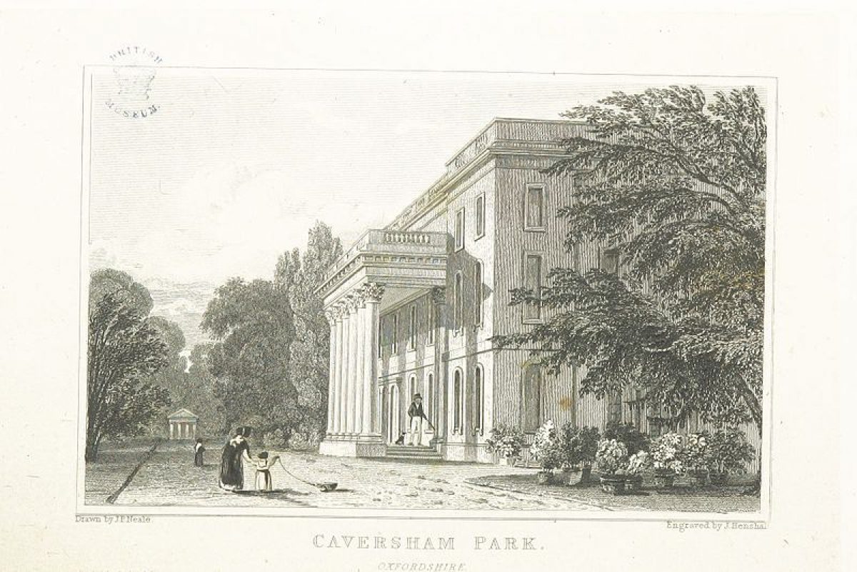
Caversham Park (1850s, possibly J T Crews, listed grade II) stands at the centre of the northern half of the site, at the top of a slope down to the Thames to the south-east, overlooking Caversham and Reading and beyond this a low range of wooded hills. The three-storey ashlar house replaced a series of houses , the last of which, dating from the late C18, burnt down in 1850. The house has been modified and extended for office use during the mid to late C20.
Gardens and Pleasure Grounds
The gardens consist of formal 1720s and mid C19 terraces descending south from the garden front of the house, flanked by wooded pleasure grounds containing further remains of the formal 1720s layout.
The south, garden front of the house opens onto a broad gravel path running along the top of an adjacent terrace. From here three flights of stone steps descend a grass bank to a rectangular lawn, from the south side of which three further flights of stone steps descend to a lower rectangular lawn bounded on the south side by an iron fence dividing the lawn from a paddock beyond. The paddock is now (1998) part of the parkland, but formerly (OS 1877; 1914) was part of the pleasure grounds, divided from the parkland by a ditch and bank, possibly part of a former ha-ha. The remains of the ditch, lying c 150m south of the house, are bounded by a sporadic, informal hedgerow.
The upper terrace extends 200m from the west end of the house, laid to grass flanked by clipped laurel hedges and beyond this woodland, and terminated at the west end by a stone temple (C19, on the site of an earlier structure, listed grade II) with a tetrastyle Doric portico overlooking the length of the terrace to the east. From here a path runs south-east down the hillside on which is situated the west arm of the wooded pleasure grounds. The path passes the west end of a 200m long canal situated 250m south-west of the house. Surrounded by a grass path, the canal is set within woodland, overlooking to the east the lower lawn lying south of the house.
From the canal the grass path continues south-east along the west boundary of the pleasure grounds, turning north-east 300m from the house to run along the northern boundary of the former walled kitchen garden. Some 150m south of the house the path turns north to arrive at the east end of the canal from where informal lawns planted with specimen trees and shrubs extend north to the upper terrace by the house.
The broad gravel path on the upper terrace extends through the wooded eastern arm of the pleasure grounds, terminating at the boundary, 250m east of the house. An informal path encircles this arm of the pleasure grounds, leading south-east off the gravel path at the east end of the house. A small, south-facing wooden pavilion stands within the southern half of the woodland, close to the southern edge, possibly having formerly overlooked the park sloping away to the south, before trees obscured the view. The area north of the west/east axial path has recently been replanted with specimen trees set in informal meadow, and also contains transmitting equipment. A brick wall (C18/C19, listed grade II) encloses parts of the boundary of this arm of the pleasure grounds to the north and east.
In the 1720s Switzer's grand garden surrounding the house (described and depicted in Vitruvius Britannicus 1725) contained parterres to the east and south. Two 200m long canals were constructed, possibly with cascades and amphitheatres at the outer ends as quoted for by Switzer (Berkshire RO: D/EX 258/9), on the hillside to the south-west and south-east of the house. The present canal appears to be one of these two, and was at that time flanked to the south by a wilderness containing a serpentine path. This area, now wooded, retains some mature yew trees and sculpted land formation.
By the mid C18 (Rocque, 1761) the axial terrace walk was dominant in the garden, terminated at the west end by a garden building. A third canal appears to have been added by this time, lying adjacent to that lying south-west of the house, and several of the parterres seem to have been removed and others simplified. Brown's landscaping retained the axial terrace path and the canals. By the 1870s (OS 1878) the two terraced lawns had been constructed below the centre of the great axial terrace, the lower one being dotted with small, oval flower beds. Additionally, two of the canals had gone, leaving that shown on Switzer's plan lying to the south-west of the house, although in shorter and wider form than that advocated by Switzer, and more rounded in outline.
Park
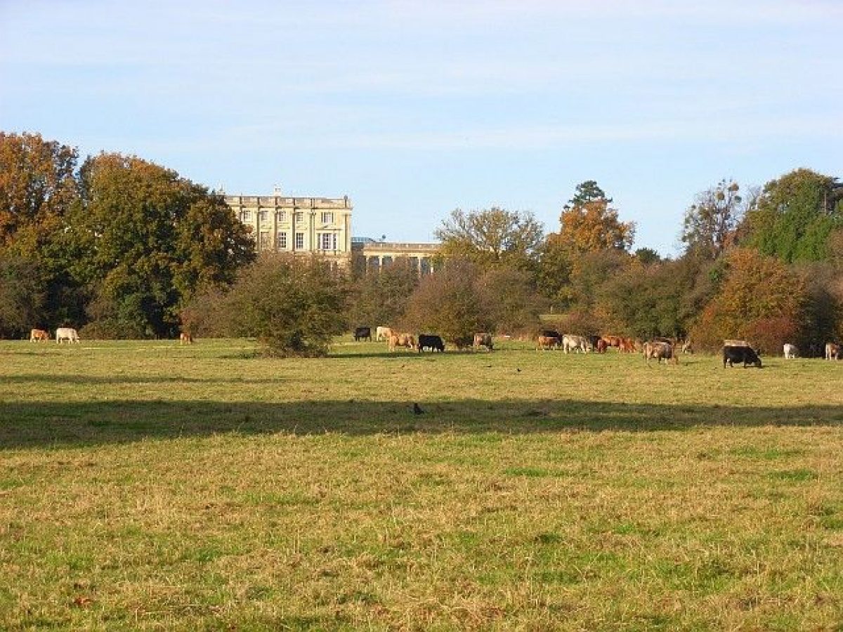
The remains of the park are divided into two sections, the area north of the house, and that extending south from the garden and pleasure grounds. The northern section, occupying a plateau, is now largely given over to playing fields with trees planted around the northern perimeter. The north park is overlooked by the north, entrance front of the house, and enjoys views north towards a low, wooded hillside lying beyond Caversham Park Village. The Village occupies land that was formerly part of the park.
The southern section of the park, laid to pasture with two clumps of trees, occupies the south-facing slope overlooking Caversham, Reading and beyond this low, wooded hills. Formerly (before Caversham's C20 development) the park probably enjoyed views down to the Thames.
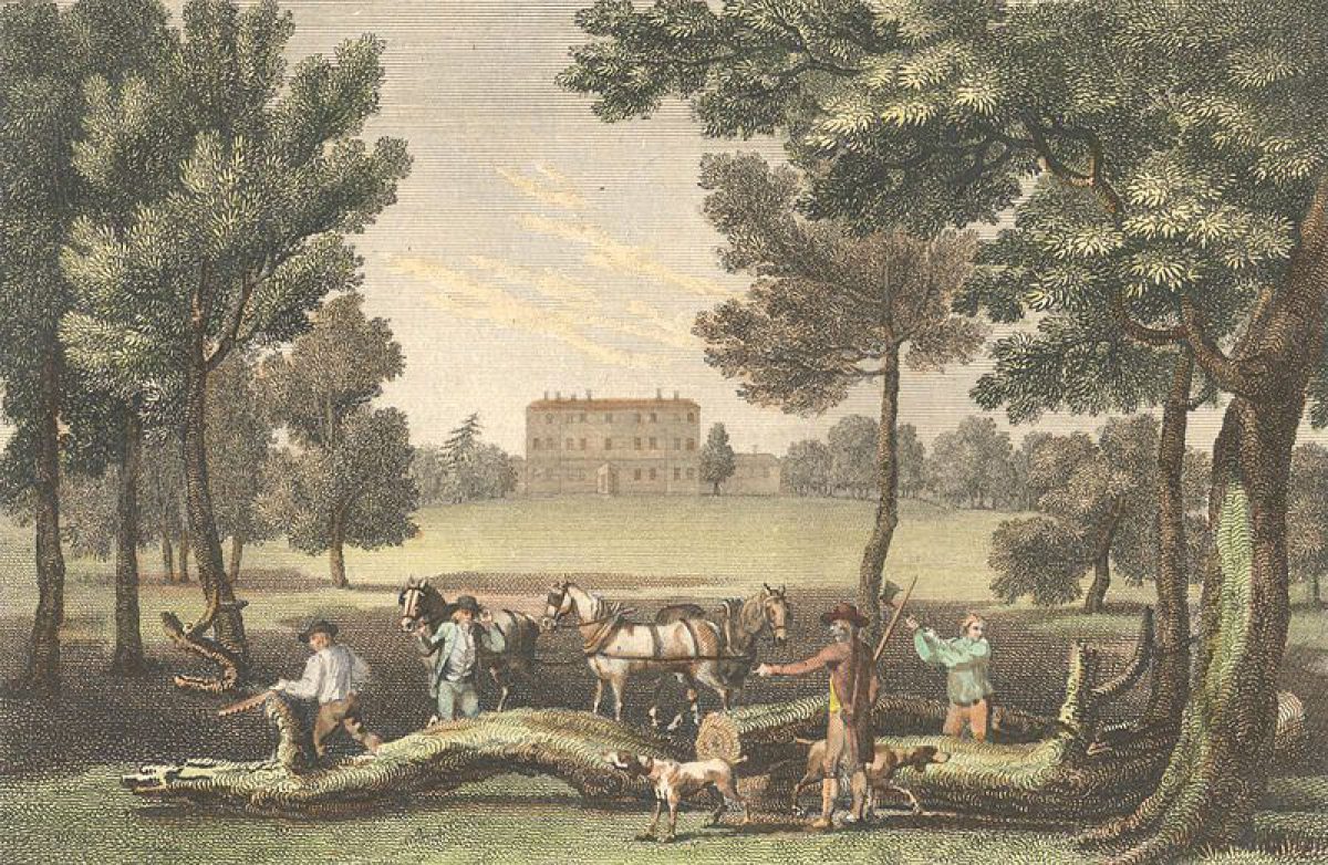
In the early C18 (Vitruvius Britannicus, plan of 1723) the broad entrance avenue extended from the north front across what became the north park, flanked by four rows of trees to either side. To the east lay open parkland containing a sequence of formal ponds and a farm complex. To the west of the avenue lay a formal arrangement of trees, possibly an orchard, and a further rectangular pond. Three parallel avenues extended from the gardens on the south front across extensive lawns which subsequently became the south park, flanked to west and east by belts of trees laid out in rows. In the description accompanying the Vitruvius Britannicus plan, the park beyond was mentioned as being well-wooded, watered and stocked with deer, with reference to an excellent pheasantry and a menagerie.
This arrangement remained largely intact until the mid C18 (Rocque, 1761), Lancelot Brown landscaping the estate in the 1760s. The park retained much of Brown's work until the 1960s and 1970s, when it was much reduced on all sides by the construction of Caversham Park Village and associated items including Reading Crematorium, Cemetery and allotments, and a school.
Kitchen Garden
The brick-walled kitchen garden (C18/C19, listed grade II) lies 200m south-west of the house, at the south-west corner of the park, and is now (1998) largely filled with mobile homes. Brick cross walls divide the area into several compartments, connected by communicating arches, and support mid C19 potting sheds. The walled garden is reached via a straight lane from the Peppard Road to the west, the entrance being marked by a C19, two-storey lodge lying 500m south-west of the house.
Maps
- J Rocque, Map of Berkshire, 1761
- T Pride, A topographical map of the Town of Reading and the County adjacent to an extent of 10 miles, 1790
- OS 6" to 1 mile:
- 1st edition surveyed 1877
- 2nd edition published 1914
- 3rd edition published 1938
- OS 25" to 1 mile:
- 1st edition surveyed 1878
- 2nd edition published 1913
- 3rd edition published 1932
Description written: September 1998
Register Inspector: SR
Edited: March 2000
- Visitor Access, Directions & Contacts
Website
https://www.cavershampark.co.ukDirections
At the south-east of Caversham, north of Reading.
Owners
British Broadcasting Corporation
- History
The following is from the Register of Parks and Gardens of Special Historic Interest. For the most up-to-date Register entry, please visit The National Heritage List for England (NHLE):
17th - 18th Century
Lord Craven owned the Caversham Park estate during the mid to late C17, rebuilding the Elizabethan manor house after 1660, probably with William Winde as the architect. The estate was sold in 1697, passing by the 1720s into the hands of William, first Baron, and later Earl, Cadogan (d 1726). Cadogan, a soldier and friend of the Duke of Marlborough, rebuilt the manor house in grander style, probably on a new site. A detailed agreement of 1718 between Stephen Switzer (1682-1745) and the Earl of Cadogan (Berkshire RO) describes a proposal to make terraces, canals, fisheries and a great formal parterre, for £1394, which corresponds closely with a plan of 1723 published by Colen Campbell in Vitruvius Britannicus III, 1725 (Bisgrove and Stoneham 1993). Campbell's accompanying description mentions a Mr Acres, who was probably employed to lay out the extensive formal garden surrounding the house, which was constructed around an axis described as a 'noble terrace, which is twelve hundred feet long'.
In the mid 1760s Lancelot Brown (1716-83) was employed by the second Baron Cadogan to landscape the grounds, at which time the formal gardens, still present in the 1750s (Rocque, 1761), were largely swept away, although Brown incorporated major structural elements into his own designs. It appears that none of Brown's drawings survive, nor his account books for this period. The results of Brown's work are described by Thomas Whately in his Observations on Modern Gardening (1770), and again by Thomas Jefferson in his 'Memorandums Made on a Tour to Some of the Gardens in England' (1786). The house burnt down during this period, being replaced by a smaller building, enlarged by Major Charles Marsack following his purchase of the estate in 1784.
19th - 20th Century
William Crawshay bought the estate in 1838, following a period of some dilapidation (National Trust 1990) and in 1850 the house burnt down once more, to be rebuilt again, this time possibly by J T Crews. The Crawshays sold the estate in 1920, it being occupied by the Oratory School until the Second World War. During the War the BBC moved into the house, which remains the home of their Monitoring Service. Large parts of the parkland were engulfed by Caversham Park Village in the 1960s and 1970s.
- Associated People
- Features & Designations
Designations
The National Heritage List for England: Register of Parks and Gardens
- Reference: GD1503
- Grade: II
Features
- House (featured building)
- Earliest Date:
- Parkland
- Terrace
- t
- Key Information
Type
Park
Purpose
Ornamental
Principal Building
Education
Survival
Extant
Hectares
40
Open to the public
Yes
- References
References
- {English Heritage Register of Parks and Gardens of Special Historic Interest} (Swindon: English Heritage 2008) [on CD-ROM] Historic England Register of Parks and Gardens of Special Historic Interest
- Pevsner, N. {The Buildings of England: Berkshire} (Harmondsworth: Penguin, 1966) p 111 The Buildings of England: Berkshire
- Campbell, C., (1725), pl 96 Vitruvius Britannicus III
- Stroud, D., (1975), p132, pl 35a Capability Brown
- Kift, M., (1980), pp 56-9 Life in Old Caversham
- Kift, M., (1983), p19 Look Back at Caversham
- Hunt J D, and Willis, P., (eds), (1988), pp 299, 334 The Genius of the Place; The English Landscape Garden 1620-1820
- (National Trust Classics 1990), p110 In Search of English Gardens: The Travels of John Claudius Loudon and his wife Jane
- Bisgrove, R., and Stoneham J., (1992) [copy on EH file] History of the Caversham Park Landscape
- Malpas, J., (1997) Caversham Park and its Owners