Introduction
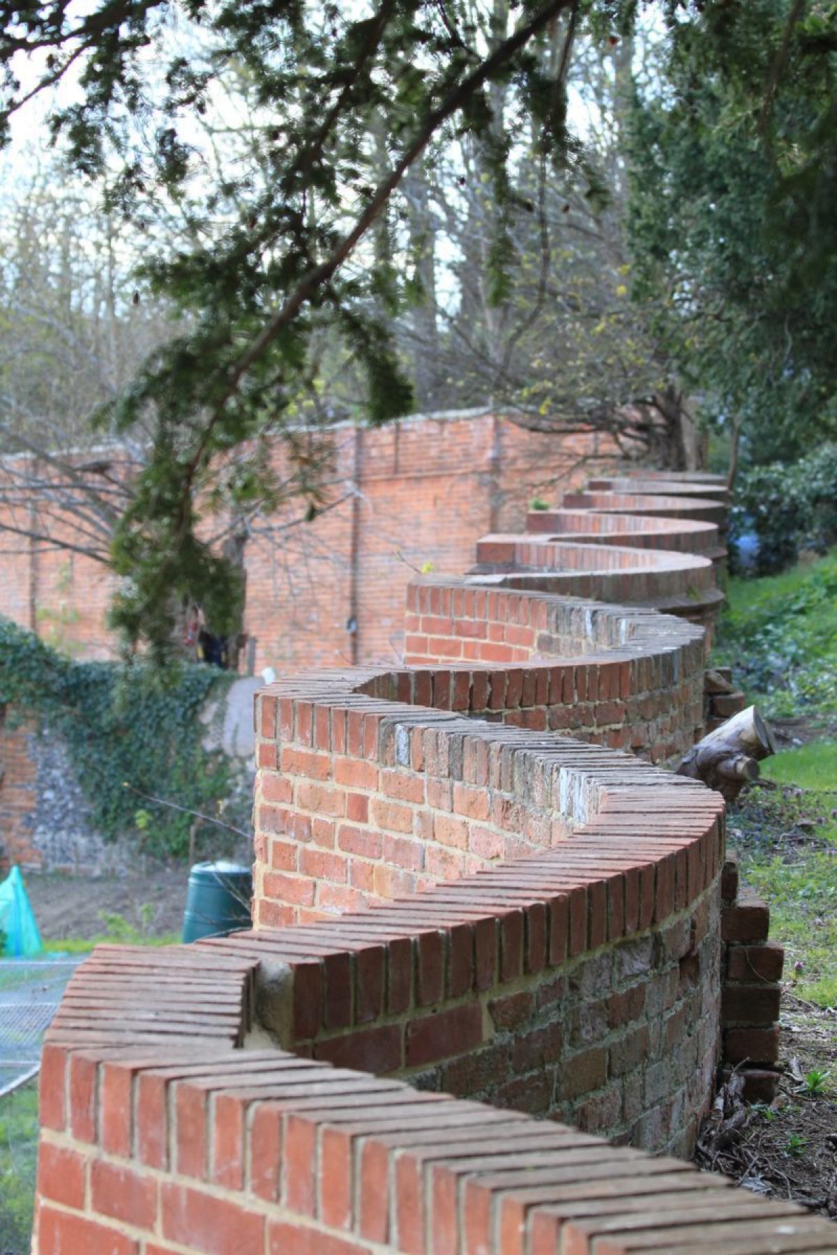
Originally a 17th-century or earlier garden, the site now covers about 1.3 hectares and is a 20th-century public garden. It includes a 'crinkle-crankle' wall.
Terrain
The garden lies at the south, bottom end of a slope from the Chiltern Hills to the north, having been dramatically terraced from the north boundary.The following is from the Register of Parks and Gardens of Special Historic Interest. For the most up-to-date Register entry, please visit The National Heritage List for England (NHLE):
A C17 garden related to the former rectory (demolished early C20), now a public park.
Location, Area, Boundaries, Landform and Setting
Caversham Court lies at the heart of the oldest part of Caversham, on the south boundary of the town, close to Caversham Bridge which gives access across the River Thames from Reading. The 1.5ha site is bounded to the south by the river, and to the north largely by the churchyard lying adjacent and above to the north, this boundary being marked by a 4-5m high brick retaining wall (C18 and later, listed grade II). A large section of the wall, particularly that below the church, is of concave panels let into the bank, linked by piers, now (1998) much obscured by heavy ivy and other creeper growth. The wall stretches westwards to the west corner of the site, the western length having been used to support lean-to greenhouses in the C19 (OS). The garden lies at the south, bottom end of a slope from the Chiltern Hills to the north, having been dramatically terraced from the north boundary with the churchyard (which lies c 4m higher than the terraced garden compartment below) down to the riverside. The setting is urban, with views across the river from the garden to the former meadows beyond (now public open space). The church dominates views north.
Entrances and Approaches
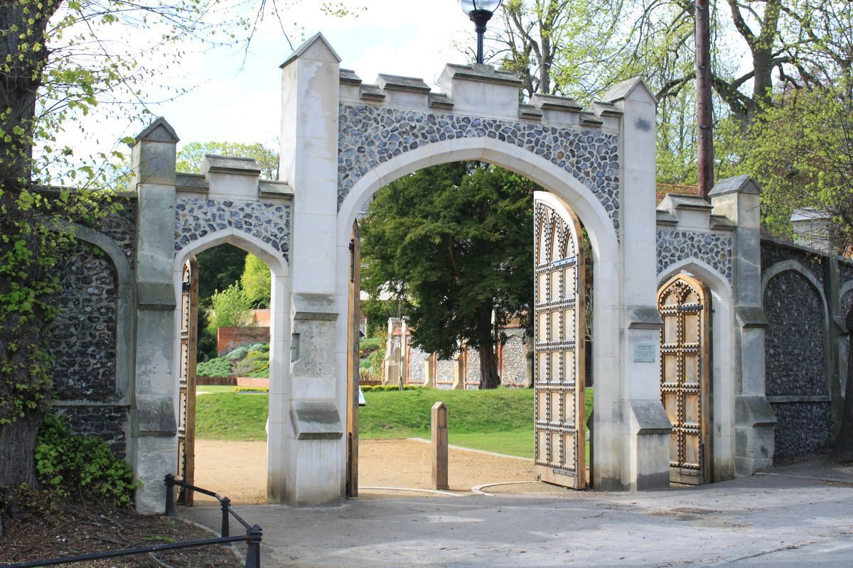
The main entrance approaches from the east off the A4074 Church Road, which connects Reading and Caversham with Wallingford to the north-west. The entrance, set back off the road and standing on an axis with the site of the former house c 10-15m to the west, is flanked by a 3m high panelled wall of flint and stone (early-mid C19, possibly A W Pugin, listed grade II). The wall largely encloses an open courtyard to the west, which lay in front of the former house. The wall continues south, forming the boundary with the adjacent rectory to the east and north, turning west to form the north boundary of the entrance courtyard. A further gateway is set into this northern section, flanked by wooden gates, giving vehicular access from the stable court to the north.
Principal Building
Caversham Court stood towards the east side of the site, built around three sides of a courtyard closed to the east by a wall, with a doorway giving access to the present courtyard to the east. Originally timber framed and gabled, it was remodelled in the late C18/early-mid C19, apparently being gothicised externally, with work by A W Pugin. By the early C20 the entrance courtyard was dominated by a gothic entrance tower, crenellated and with four crenellated corner turrets (Sale particulars, 1931). At this time the south, garden front was also crenellated and stuccoed, with two full height bays at either end, the whole overlooking the terraced lawns to the south running down to the river. The house was demolished in 1933, and there are no visible remains.
The east-facing stable yard lies to the north of, and adjacent to, the site of the former house, entered via a short drive west off Church Road. The approach is bounded on the south side by mature lime trees, arriving at a gateway set into an extension of the flint-panelled wall around the entrance courtyard to the house. The cobbled yard, enclosed on the other three sides by ranges of buildings, is dominated by the tall, two-storey brick stables standing on the west side (mid-late C17, listed grade II), with a large detached coach house adjacent to the north (late C19, listed grade II).
Gardens and Pleasure Grounds
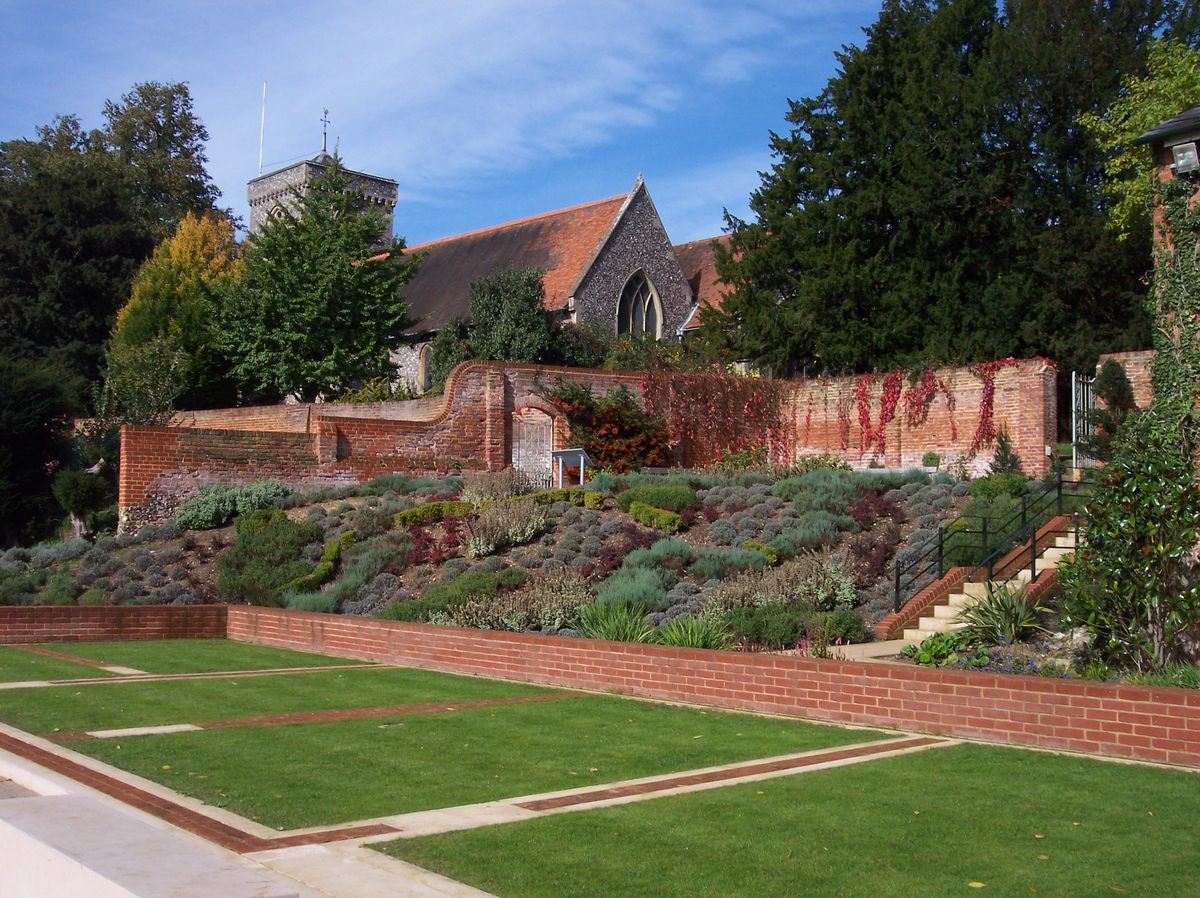
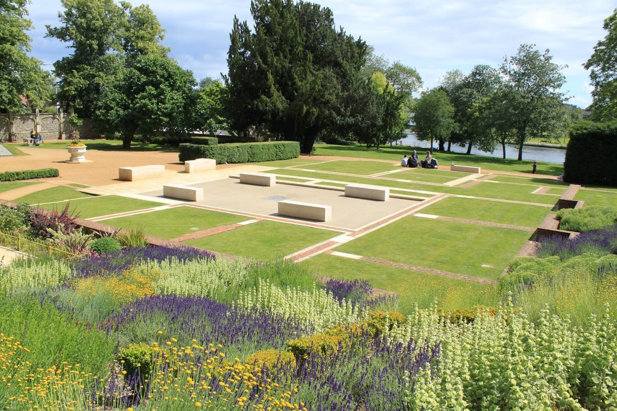
The garden is divided into two main sections to the north and south of an axial terraced walk running east/west through the centre, 50m north of the river. The southern section is entered from where the south, garden front of the house formerly stood, giving access onto the 100m long, low, gravelled terrace running west to east and forming the north boundary of the southern section of the garden, terminated at the east end by the garden boundary wall. The 20m length adjacent to the former south front gives onto a gentle grass slope down to the open lawn below. Extending 20m east from this, the terrace is bounded to the south by a brick terrace wall which formerly (OS 1898, 1932) supported a conservatory or other form of glasshouse on its south side at the lower level. The terrace walk extending 60m west from the former south front is also bounded on the south side by a 1.5m high, brick retaining wall (C17, probably rebuilt C18, listed grade II), broken towards the centre of this section by a short flight of stone steps flanked by stone gate piers. The north side of this section of the walk is bounded by a tall yew hedge. The walk leads west overlooking the terraced lawn below, and the river and former meadows beyond, arriving at the north end of the remains of a raised walk running south, supported by brick walls (C17, listed grade II), now overgrown.
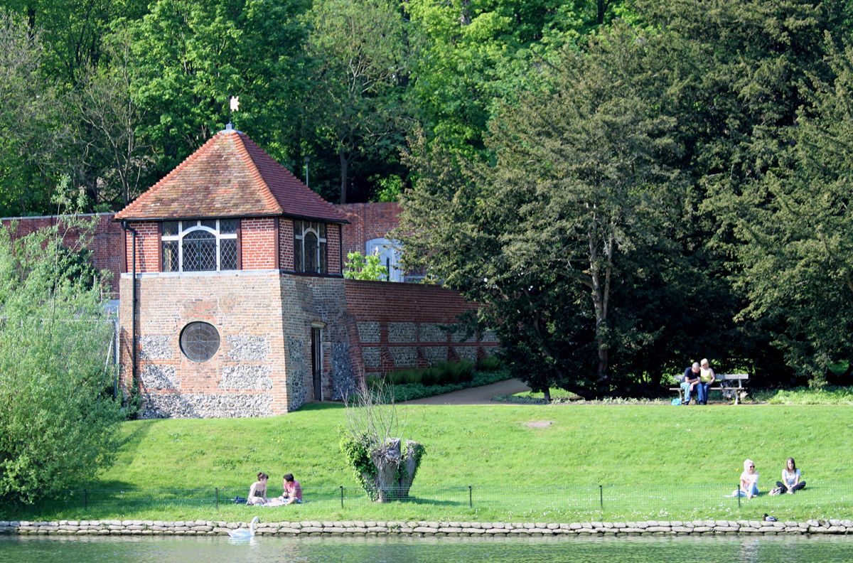
The raised walk leads 20m south to a two-storey brick gazebo (early-mid C17, listed grade II), of square plan with a pyramidal tiled roof, with access on the north side via a door at first-floor level. The first floor, designed as a viewing platform, has windows (now boarded up, original frames possibly lost) set into each of the other three sides overlooking the garden to west and east and the river to the south and former meadows beyond, possibly formerly with views towards the centre of Reading (now obscured by C20 buildings). The ground floor of the gazebo is reached via two doors set into the west and east sides, that to the west with a rusticated flint surround. A path lying adjacent and to the east of the raised walk from the north leads south down from the west end of the axial terrace, giving access to the lower floor of the gazebo. From the east door a gravel path leads along the top of a grass bank, formerly running along the whole length, now running down the bank onto the lawn below which runs down to the riverside. Formerly the gravel path was aligned with the lower floor doors of the gazebo, so that with both doors open a view was gained into the garden compartment to the west (Sale particulars, 1927).
The terraced lawn, lying at two heights below the main east/west axial path and running down to the river, is divided by a low grass bank running west to east, and contains specimen exotic trees, together with shrub and flower beds. A small public convenience building in Picturesque style (mid C20) stands by the east boundary.
West of the site of the former house, lying north of the axial walk and the large yew hedge, lies the other half of the garden, bounded on the north side by the tall, panelled, brick retaining wall, and dominated by the church above. Largely level, it is now (1998) used as demonstration allotments. The west end is partly divided from the former kitchen garden beyond by the remains of one of the retaining walls running north, from the raised walk from the gazebo to the north boundary wall.
Kitchen Garden
The site of the C19 kitchen garden occupies the west corner of the site, reached from the west end of the north garden section, and from the south garden section via the west door in the ground floor of the gazebo. The area, bounded to the north by the extension west of the north boundary wall, formerly contained several glasshouses, including a narrow peach house against the north wall. It is now used as allotments, dominated by a large brick boathouse/clubhouse (1997-8) standing in the west half.
Maps
- J Rocque, Map of Berkshire, 1761
- OS 6" to 1 mile:
- 1st edition published 1877
- 2nd edition published 1914
- 3rd edition published 1932
- OS 25" to 1 mile:
- 1st edition published 1877
- 2nd edition published 1898
Archival items
- Sale particulars, 1927 (Reading Local Studies Library)
- Sale particulars, 1931 (Reading Local Studies Library)
Description written: June 1998
Register Inspector: SR
Edited: March 2000
- Visitor Access, Directions & Contacts
Website
https://home.fccg.org.uk/Access contact details
This site is a public riverside park.
Directions
In Caversham, north of Reading
Owners
Reading Borough Council
Bridge Street, Reading, RG1 2LU
- History
The following is from the Register of Parks and Gardens of Special Historic Interest. For the most up-to-date Register entry, please visit The National Heritage List for England (NHLE):
16th - 17th Century
Until the Reformation, Notley Priory in Bucks owned St Peter's church, Caversham and its rectory, it being surrendered in 1538 and sold into private ownership. Following the Restoration of Charles II in 1660 the Rectory was leased to Thomas Loveday (d 1681) who subsequently bought the property and probably laid out the garden; following his death it was leased to Christ Church, Oxford.
20th Century
By 1909 Caversham Court, as the Rectory was by then called, was sold by the owner Lt Col Caversham Simonds, whose family seem to have owned the property from 1799 (Markham and Arnold). It was again sold in 1931, and shortly afterwards the site was bought by Reading Corporation, the house being demolished in 1933, and the gardens opened to the public at Easter 1934. The site continues today (1998) to be used as a public park.
- Associated People
- Features & Designations
Designations
The National Heritage List for England: Register of Parks and Gardens
- Reference: GD1572
- Grade: II
Features
- Boundary Wall
- Crinkle-crankle Wall
- River
- Riverside Walk
- Key Information
Type
Park
Purpose
Recreational/sport
Principal Building
Parks, Gardens And Urban Spaces
Survival
Part: ground/below ground level remains
Hectares
1.3
Open to the public
Yes
- References
References
- {English Heritage Register of Parks and Gardens of Special Historic Interest} (Swinodn: English heritage 2008) [on CD-ROM] Historic England Register of Parks and Gardens of Special Historic Interest
- Pevsner, N. {The Buildings of England: Berkshire} (Harmondsworth: Penguin, 1966) p 110 The Buildings of England: Berkshire
- Reading Borough Council {Caversham Court Gardens Management and Maintenance Plan Reading Borough Council April 2009 to March 2019} (2013) Caversham Court Gardens Management and Maintenance Plan Reading Borough Council April 2009 to March 2019
- Friends of Caversham Court Gardens {Caversham Court Gardens A Heritage Guide} (Two Rivers Press: Reading, 2012) Caversham Court Gardens A Heritage Guide
- Markham, S., and H Godwin Arnold H., Reading (nd) The Gazebo and Caversham Court
- no 2 (1976), pp 10-13 Garden History 4
Contributors
Friends of Caversham Court Gardens