Introduction
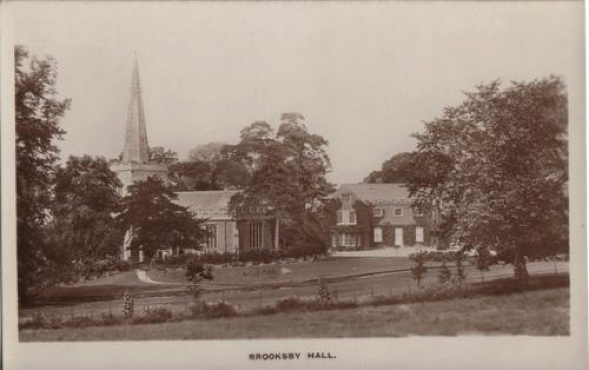
Brooksby Hall is set in 31 acres of grounds, sloping northwards down to the River Wreake. The estate is the country campus of Brooksby Melton College of Further Education and offers training in a wide range of country skills. It was formerly the county agricultural college. The Hall, originally a late 16th Century country house, was extended in the late 19th century. It houses administrative offices for the College as well as offering conference, banqueting and wedding facilities. In the grounds to the south of the Hall, is the Church of St Michael, which dominates the landscape. Modern college buildings, dating from the 1950s to 1970s are located to the north and east of the Hall. The gardens, which are informal in style, include a lake and a stream. The wide range of planting reflects the College's status as a horticultural college.
Terrain
Sloping south to north and east to west- Visitor Access, Directions & Contacts
Telephone
01664 855262Website
https://www.brooksbyhall.co.ukDirections
Brooksby lies approximately 11 miles to the north-west of Leicester. It is located just off the A607, Leicester to Melton road and is sign-posted Brooksby College. It is on the main bus route between Leicester and Melton Mowbray.
Other Websites
- History
In the late 9th century, Brooksby village evolved as a Danish settlement. The place name probably came from Brochi, meaning a badger.
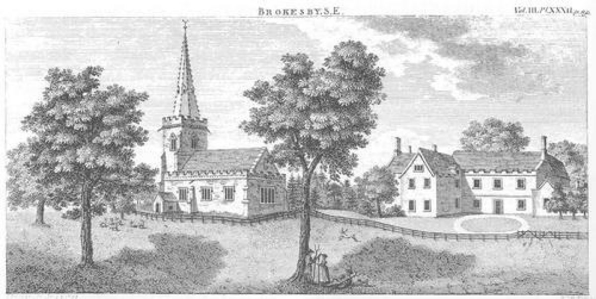
In 1085 Hugh Lupus, Earl of Chester and his wife, Countess Judith (niece of William the Conqueror) held land and possessions at Brooksby.Around 1210, Brooksby apparently came into the ownership of the Villiers family, through marriage. They were a Norman French family who were granted lands in Leicestershire. In 1235, the first reference was made to a Villiers at Brooksby: Alexander de Villiers of Kinoulton and in 1254, his son, Richard, is recorded as living at Brooksby. In 1348-49 the village was depopulated, due to plague. From 1450 to 1603, the village declined further and was eventually totally depopulated. This was mainly due to enclosures for Sir John Villiers to profit from the wool trade. According to Hoskins, the village had completely disappeared by 1603.According to an earthworks survey carried out by F.R. Hartley, published 1987, a substantial house platform from the medieval village lies to the south of the church. There were also two mounds, enclosed by ditches and banks which might have been rabbit warrens. In 1480 William Villiers and his two wives, Joan and Agnes, were buried in BrooksbyChurch in a fine tomb. Pevsner gives a detailed description of the church and its monuments.In 1592 George Villiers, who became 1st Duke of Buckingham, was born at Brooksby. He lived in Leicestershire till the age of 13. He went to school in Billesdon and also stayed with his mother at Goadby Marwood. He became a favourite of James I, (he was probably introduced to the King at Apethorpe in Northamptonshire). He became extremely powerful (and unpopular) during the reign of Charles I. In 1620 he married Katherine Manners, daughter of the Earl of Rutland. He was assassinated in 1628.In 1711 the end of the Villiers line came with the death of Sir William Villiers, without issue. (There is a monument and tombstone in BrooksbyChurch). The title became extinct and the Manor of Brooksby was sold.The estate was sold to Sir Nathan Wright, a barrister and Lord Keeper of the Great Seal of England. He was also Recorder for Leicestershire and King’s Sargeant. He did not live at Brooksby and died in 1721. In 1775 the church rector, Thomas Orton, was the only name in the records. The Hall seems to have been rented out.In 1800, an illustration of BrooksbyChurch and Hall was included in John Nichols’ History and Antiquities of Leicester. This shows the front of the Hall prior to the addition of the East Wing. A post and rail fence runs across from the Church, close to the Hall, dividing the Park from the gardens and there appear to be an extensive group of trees to the west of the Hall. The entry in Nichols relates to the history of the Villiers family and also the monuments in the church. Unfortunately, it does not describe the Hall nor the surrounding park and gardens.In 1830, the Hall passed by marriage to the Wyndham family of Cromer, Norfolk, who leased it as a Hunting Box. The property was used for this purpose throughout the 19th century with various illustrious people leasing it during the hunting season. It became a venue for the Quorn Hunt to meet. Lord James Brudenell (later 7th Earl of Cardigan) of ‘Charge of the Light Brigade’ fame, together with his wife, leased Brooksby for hunting.In 1831, His charger, Dandy, collapsed and died at Brooksby and was buried under a large elm tree on the lawn. There is a memorial stone in the west wall of the Hall.By 1848, ownership of the Estate was split between two Wyndham sisters, Maria Anne and Cecelia, who later became Lady Paget and Lady McDonald. (One of the present-day Halls of Residence is named Paget, after her).
A Tithe map of 1848 shows that the WalledGarden was already in existence by this date. It was divided by paths. The map also shows a cluster of buildings in the location of the gardener’s cottage (known today as the Rectory). There was only a single main driveway on this map. There was no secondary drive as seen by 1884.In 1850, the Hall was purchased by the Charltons. It was boarded up and empty between 1863-65. From 1865-1890, the Chaplins owned the Hall and lived there. Ernest Chaplin was largely responsible for the restoration of BrooksbyChurch after severe damage caused by a lightning strike in 1874. The Ordinance Survey map of 1884 shows the extent of the gardens at this time. The West boundary was approximately along the line of the present-day path near to the stream. It appears to have been fenced and there was a change of level of more than a metre outside the fence. This was possibly a ha-ha or just a ditch. The cluster of buildings in the location of the gardener’s cottage (shown on the 1848 tithe map) has reduced to a single building). In 1891, the Hall was purchased by a Mr. Joseph Grout Williams of a wealthy mining family from South Wales. The House had a major rebuild and enlargement, including the addition of the east wing. Bay windows were put in to both the front and side. The west side of the house is older. The architects were R.J. & J. Goodacre of Leicester. The Builders were T. & H. Herbert.The Hall was lived in by Joseph Williams’ brother, Captain Stanley Williams. At this time, the garden was mainly open parkland with formal trees and shrubs around the house. There were traditional estate railings. From photographs of that time, the trees appear to be about 100 years old.Mr. J.G. Williams was a keen agriculturalist and horticulturalist.There is believed to have been an icehouse located where the present-day Paget accommodation block is situated. It is not know when this was constructed.From 1894 to 1895, the Duchess of Marlborough leased the Hall. In 1897, Captain Williams died in a hunting accident and in 1898, H.T. Barclay, the banker, leased the Hall.The Estate was put up for sale in 1904. Comprehensive sale details describe “The Pleasure Grounds” as being “most interesting and charming” and “of a very compact and secluded character”. There were croquet and tennis lawns, terraced walks, fine specimen trees and ornamental flower beds and plantations. The Walled Kitchen garden is described in some detail, as is a fruit and flower garden beyond it.The description also mentions the Gardener’s Cottage (the house to the south of the Church, now known as ‘The Rectory’. There was a Bothy for the under-gardener at the side, as well as two glass houses in the garden. These appear on the 1903 OS map. It is interesting to note that, on this map, the cottage is a different shape to the building shown in 1884 (and on the 1848 tithe map). This would indicate that the present day cottage was built sometime between 1884 and 1903.
A cluster of buildings is visible on the east side of the walled garden, one of which is believed to be the present-day ‘Mole Cottage’. These were not present on the 1884 map. Also visible on the 1903 map is a double line of trees (understood from oral history to be chestnut). This extended from the
Melton Road to the Church and is believed to be a bridleway.The Estate failed to sell at auction.Between 1905 and 1906, the Hall was empty.Several invoices in the Leicestershire and Rutland Record Office, dated 1905-06, indicate that Mr. Williams was still buying plants for his properties at Tring, in Hertfordshire and Brooksby. It is clear that he preferred to use mostly local nurserymen for this; however, he placed orders for fruit trees, vegetable seeds and plants with renowned nurserymen, James Veitch & Sons Ltd., Chelsea.
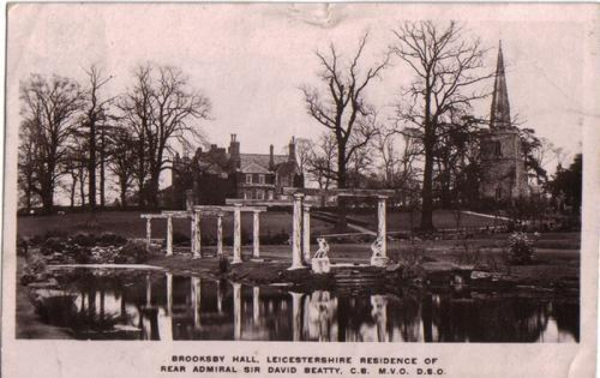
In 1906, Earl (then Captain) Beatty leased the Hall and 64 acres from Mr. Joseph Grout Williams. It was a 14-year lease. Beatty had married Ethel Field, an American heiress, in 1901.
In summer 1906, he commissioned Thos. Messengers of Loughborough to construct a plant house stove and pit. Beatty had been advised that the existing greenhouses were unsuitable for peaches and decided to remove these and to erect a new peach house and a vinery on the south-facing wall. However, as he was only leasing the property, the work was scaled back. It appears that only the Plant House Stove and Pit and foundations for the greenhouses were completed at this time. Correspondence relating to this is in the Leicester Record Office.
Also in 1906, plans were drawn up for Captain Beatty for a cottage. (These are also in the Record Office) The design appears very similar to the present day bungalow on the Hoby Road. This is believed to have been a cottage for the Head Gardener. It is not know at what date it was actually built.On 10th October 1911, Beatty purchased the Hall and 186 acres for £22,000 According to John Hubbard’s History of Brooksby, Beatty engaged Lutyens to carry to carry out minor alterations in the Hall. He had already done work for them at their other property, Dingley. The 1911 Census shows that there were three gardeners employed at Brooksby Hall: Albert Edward Smith, George Crofts and Cyril Victor Seddon.Between 1911 and 1915, the garden was extended out westwards into the parkland. A postcard, franked 7th August 1915, shows the lake and a stone pergola. The pergola terminates at the lake and there are two Italianate statues. Pevsner attributes the pergola to Lutyens, but no evidence for this has been found. The lake was constructed by Irish workmen, using the ‘puddled clay’ technique. It seems unlikely that Beatty would have embarked on a major project of this nature until he had purchased the Hall, so the date estimate is based on this. The garden was developed further in the 1920 and early 1930’s. The History of Brooksby states that the stream from the Church to the Lake was constructed in the early 1920’s. However, it is possible that this was also pre-war. It is not possible to see from the postcard image whether the stream is already there in 1915. The water for the stream was fed via pipes and drains from the sloping ground between the turnpike road and the Hall. A rockery was also put in during this period, with rocks alongside the stream. Three Chamaecyparis Pisifer Filifera Aurea trees were planted alongside the stream.Mr. Watson, ex parks superintendent for Leicester Corporation was head gardener and many plants came from Kew.
The Brooksby History also states that Beatty had a Dutch water garden and the roundhouse (now in the Principal’s garden) constructed at this time. However, oral history (reported from the daughter of Beatty’s agent) says that the garden was Italian in style. This is supported by a survey carried out in 1945. See below for more information regarding its location. There is no evidence for a Dutch garden.
The date of the round house, which has the appearance of an South African rondavel, remains a mystery. It is not mentioned in the 1945 survey but predates 1955, when the second Principal joined the college. It seems likely that it came from the Beatty era, but, for some reason, was omitted from the 1945 survey
Lady Beatty planted many trees, including a fine line of trees and shrubs to screen the railway line. The shrubs were subsequently eaten by pigs in the early days of the college farm but many of the trees remain.
From oral history, there is also believed to have been a Japanese style garden in the area where there are currently a group of cherry trees. Nothing more is known about this and it is not mentioned in the survey or on estate agent’s particulars.
The Brooksby History states that the avenue of trees (bridleway) from the main Melton road to the rear of the church was removed and the present-day main entrance was created during the Beattys’ ownership. However, the present day entrance and exit (at the front of the Hall) were already in place in 1884. The bridleway was still in place in 1935, according to the plans that accompanied sale particulars at that time.
After a burglary at Brooksby in the 1920s, the Beattys spent more time at their other home, Dingley Hall, near Market Harborough.In 1931, the swimming pool was installed by Joseph Goodwin and Sidney Pearce of Frisby, using a sand and gravel filtration system. The 1945 survey describes it as brick built, cement rendered, complete with inlet and outlet pipes and shaped floor.In 1932, Lady Beatty died at Dingley.In
1935, Brooksby was put up for sale. The estate agent’s particulars (in the Leicester Record Office) describe “The beautiful old-world gardens and well-timbered pleasure grounds” which “afford the fullest possible measure of amenity with limited upkeep”. There are comprehensive descriptions of the garden at this time.The property did not sell.In 1936, Earl Beatty died and the property passed to his son, David Earl Beatty, in 1937. At the time of the Munich Agreement, in September 1938, David Earl Beatty decided that arrangements should be put in hand to convert the Hall to a convalescent home. When war broke out, it was set up as a home for naval officers but subsequently became a Red Cross home for all ranks and services for the remainder of the war. David Beatty, lived in the former gardener’s cottage near to the church, now referred to as ‘The Rectory”.In 1945, on 6th May, a comprehensive survey of the condition of the Hall, Gardens and Park was carried out by Fisher & Co., for the Leicestershire County Council. This document (in Leicester Record Office) gives a full description of the state of the property at that time. It includes descriptions of the fences, roads, woodlands, gates, etc. It describes the Rose Garden (this was a yew-hedged formal garden to the south-west of the Hall) , the Lily Pond (now known as the Lake), the Kitchen Garden (this includes considerable detail, including planting), an herbaceous border and “A Further Border”, which, from the description, would appear to the “ItalianGarden” (which has been mentioned in oral history). It had ornamental balustrades (of which a piece was moved to the garden of the present day Principal’s house, after the demolition of the garden). There were also wrought-iron gates inscribed with the letter ‘B’ in the centre panel. There was a circular central lily pond.The herbaceous border is described as being “to the north of the stable building”. The exact location is unclear, as the walled garden was north of the stable building. In the 1935 sale particulars, the herbaceous border is described in the same sentence as an ornamental pool. It seems likely that these two gardens were linked; the Italian garden was therefore not behind the Church, as was originally maintained.
A possible location for both of these might have been to the back of the Hall, as there are yew hedges near to the Paget accommodation block and the 1945 survey mentions yew hedges. Alternatively, it could have been beyond the walled garden, though this seems unlikely, as the land slopes away.
On 1st June, the Hall was purchased by Leicestershire and Rutland County Council for £20,000 and it became the Brooksby Hall Training Centre for ex-servicemen under the auspices of the Leicestershire Agricultural Executive Committee.In 1950-51 the Hall became a Farm Institute. Also in the 1950s, the stream was narrowed. Photographs dated 1952 show the Italianate statues by the pergola still in place, though they appear overgrown and stained.In 1956, the Italian water garden was filled in with ashes and the area covered with soil from the foundations for the construction of the Principal’s house and the Paget accommodation block.In 1961, the main Hall and its associated residential blocks were officially opened by Alderman Coltman, the then Chairman of the Governors. In 1963, a pinetum was planted towards the west end of the garden.In 1967, Brooksby was given the status of an AgriculturalCollege.From 1970-73, the walled garden and glass houses were demolished to build the Buckingham library/lecture room block. This was built in two stages – the west half with the library and student services was built first and the laboratories later. It is situated almost in the middle of what were once glasshouses, paths and cold frames. The walled garden originally extended (east to west) from the row of brick buildings by the entrance to the staff car park across level with the far end of the Villiers Restaurant. A small fragment remains here as one side of a pumphouse. The building now called “Mole Cottage” (named after a rural crafts instructor and mole catcher!) was originally a potting shed. The building alongside (the Gym) was a boiler house for the greenhouses.The small square building, still existing at the ‘pinch point’ between the Villiers Restaurant and the Stable Bar was originally an apple store. It formed part of the south wall of the walled garden.
The demolition work was carried out in stages. One greenhouse still remained in 1973 and some of the walls were still standing in 1975. The coach house section of the stable block was demolished when the new teaching and accommodation blocks were built, also during the early 1970s.
The Horticultural Department moved to the other side of the Melton Road, to the corner of Spinney Farm.In 1973, the bog garden was replanted.In 1974, a stream running at 90o to the Hoby Road, which separated the playing field from an intervening field and the gardens to the south, was diverted into a culvert.Between 1974 and 1975, renovations were carried out to the lower part of the stream. Small rock gardens and a sunken tufa garden were constructed.A small arboretum was planted on the sloping ground between the main Melton Road and the Hall. The area had alternated between trees and pasture. It had latterly been an apple orchard and nursery.Also in 1975, as a result of rose sickness, the roses were removed from the formal yew-hedged rose garden to the south-west of the Hall.In 1976, fine tree planting dating from the Beatty period – horse chestnut and black poplar – were lost in gales. A submersible pump was installed in the lake, to improve the oxygenation. This was funded by a ‘Gardeners’ Day’ fund-raising event. As a result, it was possible, in 1977, to add carp to the lake. A shrub rose bed was planted. In 1979, the last remaining greenhouse from the walled garden was finally demolished (and sold for £50) in order to make room for additional car parking. A new parking area was laid.In 1987, 155 metres of pipework was renewed to carry pumped water from the lake to feed the top of the stream, starting near the church. A new rose garden was completed. A hedge of purple-leaved Prunus was planted at the south-west end of the garden. Three island beds, two of shrubs and one of herbaceous perennials were prepared, to increase the range of plants in the garden.In 1988, a windbreak was planted near the Hoby road. It comprised predominately native trees and shrub species to provide a habitat for wildlife. A new herbaceous bed was planted adjacent to the teaching block.From the 1990s, various garden features of a more or less ephemeral nature have been added. Some of these are student projects, reflecting the nature of the grounds as part of a horticultural college. For example, the wooden pergola from the old RoseGarden was based on a student’s design and was erected in the mid-1990s. A new rock garden was constructed in 1990 to utilise as many hard landscape materials as possible whilst still maintaining the effect of a rock outcrop.Period
- 20th Century (1901 to 2000)
- Early 20th Century (1901 to 1932)
- Associated People
- Features & Designations
Style
Informal
Features
- Building
- Description: This is now known as ?The Rectory? but was never used as such; it was the gardeners' cottages. Based on the shapes of the buildings shown on the Ordinance Survey maps, it is believed that the present building dates between 1884 and 1903. There was also a bothy. It was originally two cottages, but they were combined to make a single building. It was occupied by David Earl Beatty during the 2nd World War, when the Hall was a Red Cross Convalescent Home.
- Earliest Date:
- Latest Date:
- Stream
- Description: The stream which runs from the Church to the Lake is believed to have been constructed in the early 1920s. The water was fed via pipes and drains from the sloping ground between the turnpike road and the Hall. A rockery was also put in during this period, with rocks alongside the stream. The stream was narrowed in the 1950s.
- Earliest Date:
- Latest Date:
- Pergola
- Description: This was constructed between 1911 and 1915 and comprises eight free-standing stone pillars with timber cross beams. It terminates at the Lake. There were originally Italianate stone statues and a flight of steps down into the Lake. Pevsner attributes it to Lutyens, but this is not substantiated. In the 1935 sale particulars, it is described as a rose pergola. Some of the columns are now broken.
- Earliest Date:
- Latest Date:
- Kitchen Garden
- Description: The walled kitchen garden first appears on a tithe map of 1848. It was demolished in the 1970s to accommodate the Buckingham Centre: Library and Teaching accommodation, and to provide additional car parking space. The remaining brick buildings: a gym and a cottage known as `Mole Cottage? formed part of the east side of the walled garden and the Stables formed part of the south side.
- Earliest Date:
- Latest Date:
- Garden House
- Description: This round house resembles a South African rondavel and is situated at the bottom of the garden of the Principal?s house. It is know to have been in situ in 1955 but it is not know when it was built. It is not mentioned in the 1945 survey.
- Earliest Date:
- Latest Date:
- Outdoor Swimming Pool
- Description: The swimming pool was installed by Joseph Goodwin and Sidney Pearce of Frisby, using a sand and gravel filtration system. The 1945 survey describes it as brick built, cement rendered, complete with inlet and outlet pipes and shaped floor.
- Earliest Date:
- Latest Date:
- Structure
- Description: The Tennis Courts are described in the 1935 sale particulars and were constructed by En Tout Cas.
- Earliest Date:
- Latest Date:
- Garden Ornament
- Description: A sea mine was placed in the garden by Earl Beatty after the 1st World War. The story, which may be apocryphal, is that it was originally floated on the lake and that Beatty used it as a shooting target. It now stands on the lawn.
- Earliest Date:
- Latest Date:
- Stable Block
- Description: The stable block appears on the 1848 tithe map. The coach house had been demolished by the early 1970s to create additional teaching blocks. The stables housed laboratories until the mid-1970s and are now a student common room and bar.
- Earliest Date:
- Latest Date:
- Chapel
- Description: Church of St. Michael: Grade II*. The tower was begun in the early 14th century and completed in the 15th century. The body of the church is early 16th century. It was restored and the spire rebuilt in 1874 by R.W. Johnson. The south west nave window was inserted in 1911. There is uncoursed random stone rubble with limestone dressings and portions of old render. There is ironstone ashlar on the east and south walls. The slate roof is made of Swithland slate and has a south slope.
- Earliest Date:
- Latest Date:
- Rockery
- Description: The small rock gardens and sunken tufa garden were constructed in 1974-75 on the slope between the Hall and the Lake. Another garden was constructed in 1990 to illustrate the use of a wide variety of hard landscaping materials but still give the impression of a rock outcrop.
- Earliest Date:
- Latest Date:
- Country House (featured building)
- Description: Late C16, altered early C18 and early C19. Extended and altered 1890-1 by R J and J Goodacre of Leicester.Other minor alterations by Sir Edwin Lutyens for Lord Beatty c1912.Coursed squared ironstone with limestone dressings, Swithland slate roofs, stone lateral and ridge stacks with brick flues. H plan.
- Earliest Date:
- Latest Date:
- Gardens
- Lake
- Stream
- Key Information
Type
Garden
Purpose
Educational
Principal Building
Education
Period
20th Century (1901 to 2000)
Survival
Extant
Hectares
12.5
Open to the public
Yes
- References
References
- Hubbard, John R., {Brooksby, The Story of an Estate and its People} (Brooksby, Brooksby Agricultural College, 1977) Brooksby, The Story of an estate and its people
- Hartley, Robert F. {The Medieval Earthworks of North-East Leicestershire} (Leicester, Leicestershire Museums, Art Galleries and Records Service, 1987) The Medieval Earthworks of North-East Leicestershire
- Schedule of Record of Condition
- Leases, sale catalogues, correspondence, Brooksby Hall Estate - 19th and 20th Century
- Installation of Plant House, Stove and Pit
- Horticultural Advisory Committee Minutes - June 1974 - November 1988
Contributors
Sue Blaxland
Leicestershire & Rutland Gardens Trust