Introduction
The early 20th-century gardens of Benington Lordship occupy about three hectares around the house, with adjacent parkland of 27 hectares. The gardens include the remains of a Norman castle and moat. There is a rose garden, sunken garden, snowdrop walk and kitchen garden. The 19th-century Norman-style gatehouse and the summerhouse are made of Pulhamite (a type of artificial stone).
Terrain
. The ground is hilly, with the site bisected centrally from south-west to north-east by a valley whose hillsides lead up to opposing plateaux to west and east.www.historicengland.org.uk/listing/the-list
A country house surrounded by mid-19th- and early 20th-century gardens, within a landscape park.
DESCRIPTION
LOCATION, AREA, BOUNDARIES, LANDFORM, SETTING
Benington Lordship lies to the north-west of the south-west part of the village of Benington, c 5km east of the centre of Stevenage. The c 30ha site is bounded to the north and west by agricultural land, and to the south and east largely by the Aston to Benington lane. The parish church and churchyard form part of the south-east boundary, south of the house. The ground is hilly, with the site bisected centrally from south-west to north-east by a valley whose hillsides lead up to opposing plateaux to west and east. The setting is largely agricultural, with Benington village adjacent to the east and, 1.5km to the east, the grounds of Benington Park.
ENTRANCES AND APPROACHES
The main approach enters 150m east of the house, off the village green. The gateway, set back from the road, is flanked by tall brick piers, in turn flanked by short lengths of supporting brick wall, with to the north-east a two-storey, brick-built lodge (early C20). From here the east drive (early C20, Arthur and Lilian Bott) curves westwards through open lawns enclosed by belts of mature trees. To the south, 100m south-east of the house, stands the earthwork remains of the castle outer bailey, scheduled ancient monument), on the top of which a walk has been sited to take advantage of the extensive views across the village to distant countryside to the south and south-west.
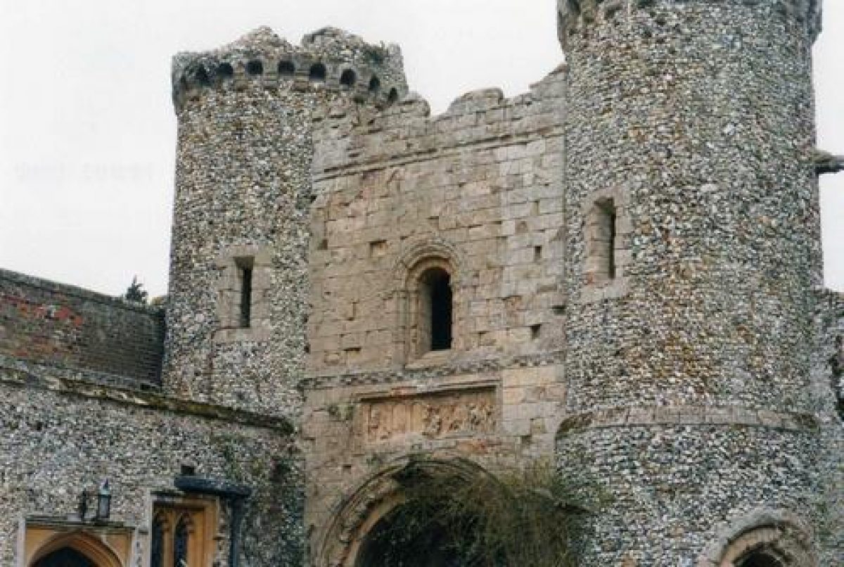
Shortly before it reaches the house, the drive curves south to arrive at the east arm of the moat and the neo-Norman gatehouse (probably Thomas Smith with James Pulham 1830s, listed grade II* with the house). The two-storey stone gateway, pierced by a Norman-style arch, is flanked by two circular flint towers and stands adjacent to a contemporary extension to the house in similar Norman style to the west, with the remains of the 1830s curtain wall to the east.
The drive emerges from the gatehouse south into the forecourt, enclosed to the west by the east front of the house, to the south by the remains of the Norman castle, and to the north-east and east by the remains of the 1830s flint curtain wall, leading south to the summerhouse (curtain wall and summerhouse probably Thomas Smith with James Pulham 1830s, listed grade II). The wall, of which sections have been lost, and summerhouse stand on a grass bank above the level of the main forecourt area, the bank being part of the C12 inner bailey which falls steeply away into the moat on the outer side. The gatehouse, wall and summerhouse, known as The Folly, were built to link the Norman keep with the house.
The two-storey summerhouse on the east side of the forecourt is built of flint with stone dressings, and is entered via steps from the lower forecourt level leading up to a large, Norman-style arch in the west wall. This overlooks the terrace along the south front of the house, and the valley beyond to the park. The house is entered via stone steps up to the main door set into the 1830s single-storey flint extension on the east front (probably Thomas Smith with James Pulham). A spur off the east drive northwards, 50m north-east of the house, leads to the stables.
Some 550m south-west of the house the two-storey Keeper's Lodge (late C19) stands at the head of the former south drive which ran north-east through the park, close to and approximately parallel with the Aston to Benington lane (OS 1878/80). Shortly before reaching the churchyard, 100m south of the house, the drive turned north, continuing below the west side of the garden and west front of the house, overlooking the valley and ponds to the west. The drive curved around to the north of the house, arriving at the Norman gateway entrance to the forecourt. A spur off this drive entered off the lane east of the church, encircling the south end of the churchyard to join the south drive c 75m south of the house. By 1898 (OS) the portion of the south drive in the park south of the church was disused or had gone, and only the spur entering east of the church gave access from the lane, joining the north end of the drive, this at that time being the main approach to the house. By 1923 (OS), when the parkland west of the house and garden had been incorporated into the garden, this northern section of the south drive had also become disused, replaced by the east drive, created by the Botts. The northern portion of the drive largely remains as a broad, gravel garden path (1999).
PRINCIPAL BUILDING
Benington Lordship (late C17, C19, listed grade II*) stands towards the eastern corner of the site, enclosed by gardens and pleasure grounds, overlooking parkland to the west and down the parkland valley to the south-west to distant countryside. The rectangular, brick-built C17 core of the house is of three storeys, with additions of the 1830s to the east (late Gothic style) and north (Norman style) in stone and flint, and to the west a substantial brick wing added by the Botts in the early C20, with an ornamental verandah overlooking the west gardens and park beyond. A service court and service door lie adjacent to the north front, with the main entrance to the house on the east front, and a garden door set into the south front.
The single-storey brick stable block (mid C19) stands 75m north of the house, adjacent to the kitchen garden to the west.
GARDENS AND PLEASURE GROUNDS
The gardens, flanked by the park to the west and south, surround the house and are broken into several formal and informal compartments.
The garden door in the south front opens onto the Rose Garden, a level lawn with a central, formal arrangement of beds. A stone-flagged path runs along the south front, with a spur leading south from this along the west side of the lawn. Above the Rose Garden, to the south, an earth bank laid to lawn (part of the C12 inner bailey) drops sharply to the south into the medieval moat. The moat is planted with mature trees, with a walk along the bottom, and separates the garden from the churchyard to the south. The west boundary of the Rose Garden is marked by a bank which drops sharply to the open, west lawns. The east side of the Rose Garden is bounded by the ruins of the Norman keep (C12, scheduled ancient monument, listed grade I) around and within which is planted the Winter Garden. The ruined keep, c 13.5m square with c 2m thick walls, has sunken flint rubble walls, with ashlar dressings. The inner bailey bank south of the Rose Garden extends along the south and east sides of the keep, bounded above the moat by a low wall, and extends north to the south side of the summerhouse.
The path along the south front of the house leads east into the forecourt between the house and keep. To the west the path leads to a flight of steps, linked to the south end of the adjacent verandah. The steps lead down to the gravel path which was formerly part of the south drive. The path is flanked to the east by the west sides of the house and Rose Garden, and to the west by the broad, terraced west lawn, overlooking two ponds in the valley at the bottom of the lawn (lawn and ponds incorporated into the garden in the early C20). The ponds are probably the remains of medieval fishponds. One of the terraces is still used as a tennis court.
The gravel path terminates at the north end at a garden compartment known as Shylock (early C20), entered via a flight of stone steps leading north down grass terraces, and sited within what may have been part of the moat. The rectangular area is laid largely to lawn, with a central circular bed, and is enclosed by clipped hedges and mature trees and shrubs. Steps lead up to the east to an orchard and wild garden, and beyond this a swimming pool enclosure. A further flight of steps leads north from Shylock up to the kitchen garden, crossing the double Herbaceous Border path adjacent to the kitchen garden.
A flight of steps leads from Shylock down to the west to the Rockery, formed in 1916 around three small pools which flow into the north end of the adjacent northernmost pond. The Herbaceous Border, flanking a gravel path broken by steps down to the west, forms the northern boundary of the garden, and is itself bounded to the north by the south wall of the kitchen garden, stepped down to the west. The Border connects the orchard at its east end with the Rockery and north pond at its west end. From the west end of the Border an informal grass path (created 1970s, brought in from the park) leads around the west side of the north pond adjacent to the park, crossing between the two ponds to return to the grass terraces beneath the west front of the house.
The south arm of the steep-sided moat curves north into the east arm, giving access to the pleasure grounds to the east of the main gardens, which contain mature trees and the outer bailey walk.
PARK The park, laid to pasture and planted with scattered mature trees, lies west and south-west of the house and gardens. Through it runs the valley which bisects the site from south-west to north-east, at the southern end of which lies Park Wood, to the west of Keeper's Lodge. Long views extend west, south-west and south from the north end of the park. An oak avenue extends westwards on the high ground west of the ponds towards the park boundary.
KITCHEN GARDEN
The rectangular, brick-walled kitchen garden (1906) lies adjacent to the north boundary of the site, and is still (1999) cultivated. It is entered from the garden via a gateway in the south wall. Adjacent to the north-east corner stands the gardener's cottage, attached to the west end of the stable block. The ground falls away to the west, so that the kitchen garden overlooks the north end of the garden and west park.
REFERENCES
Victoria History of the County of Hertfordshire 3, (1912), pp 73-5
B Jones, Follies & Grottoes (1974), p 343
B Cherry and N Pevsner, The Buildings of England: Hertfordshire (1977), pp 94/5
R Bisgrove, The Gardens of Britain 3, (1978), p 33
Hertfordshire Countryside 36, no 264 (April 1981), p 49
Country Life, 171 (13 May 1982), pp 1346-8; no 27 (8 July 1993), p 62
Benington Lordship A History, guidebook, (nd, late 1990s)
Maps
Benington estate map, 1743 (private collection)
Benington estate map, 1828 (private collection)
Dury and Andrews, A topographical Map of Hartford-shire, 1766
Tithe map for Benington parish, 1840 (Hertfordshire Record Office)
OS 6" to 1 mile:
1st edition published 1878
2nd edition published 1899
OS 25" to 1 mile:
2nd edition published 1898
3rd edition published 1923
Description written: June 1999
Register Inspector: SR
Edited: October 2000
- Visitor Access, Directions & Contacts
Website
http://beningtonlordship.co.uk/Access contact details
A private family home, with a garden which opens to the public on selected days between February-August.
Open for specific seasonal displays only (for example snowdrops).
Directions
Benington Lordship is located four miles east of Stevenage in the village of Benington, next to the Church.
- History
The following is from the Register of Parks and Gardens of Special Historic Interest. For the most up-to-date Register entry, please visit the The National Heritage List for England (NHLE):
www.historicengland.org.uk/listing/the-list
HISTORIC DEVELOPMENT
Benington Castle was built in the 1130s for the de Valognes family, slighted in 1176-7 by Henry II and garrisoned again in 1192-3. The castle was largely destroyed in 1212 after Robert Fitzwalter was outlawed, leaving only the bottom courses of the keep.
In about 1700 the Caesar family of Benington Place (now, 1999, known as Benington Park) built Benington Lordship on the site of an Elizabethan farmhouse, adjacent to the castle ruins. It was probably built as a dower house at about the same time as the family rebuilt Benington Place (which burnt down almost immediately). Benington Place, having been rebuilt and then sold to John Chessyre in 1744 (Victoria County History), burnt down once again, and at this John Chessyre moved into the Lordship.
In 1826 the last John Chessyre sold Benington Lordship to George Proctor, who, around 1832, commissioned a neo-Norman gatehouse, summerhouse and curtain wall to connect them, which together are known as The Folly, as well as additions to the house. For The Folly Proctor probably employed a local architect, Thomas Smith (1798-1875), with James Pulham (the father of James Pulham who founded the rockwork company) acting as the Clerk of Works. George Proctor died in 1840, and his son Leonard inherited the estate. Leonard built the stables, employing Obadiah Pulham, and lived on at the Lordship into the 1890s (VCH).
In 1905 Arthur Bott, a Staffordshire engineer, bought the Lordship upon his return from working in India. Mr Bott and his wife Lilian enlarged the house and garden, taking in areas of the park, and built a new kitchen garden adjacent to the stables. The existing garden areas were remodelled by the Botts, influenced by the designers of the period. By the 1970s the gardens required renovation, and were restored by the present owners during the 1970s and 1980s. The house remains (1999) in private ownership.
Period
- 20th Century (1901 to 2000)
- Early 20th Century (1901 to 1932)
- Associated People
- Features & Designations
Designations
The National Heritage List for England: Register of Parks and Gardens
- Reference: GD1904
- Grade: II
Features
- Pulhamite
- House (featured building)
- Description: The moated house dates from the early 18th century and has early 20th-century additions.
- Earliest Date:
- Latest Date:
- Kitchen Garden
- Rose Garden
- Walk
- Description: Snowdrop walk
- Moat
- Earliest Date:
- Gatehouse
- Earliest Date:
- Latest Date:
- Summerhouse
- Earliest Date:
- Latest Date:
- Parkland
- Castle
- Moat
- Sunken Garden
- Key Information
Type
Garden
Purpose
Ornamental
Principal Building
Domestic / Residential
Period
20th Century (1901 to 2000)
Survival
Extant
Hectares
30
Open to the public
Yes
Civil Parish
Benington
- References
References
- {English Heritage Register of Parks and Gardens of Special Historic Interest}, (Swindon: English Heritage, 2008) [on CD-ROM] Historic England Register of Parks and Gardens of Special Historic Interest
- Jones, B., {Follies and Grottoes} (London: Constable, 1974), p. 343 Follies & Grottoes
- Pevsner, N. and B. Cherry, {The Buildings of England: Hertfordshire} (Harmondsworth: Penguin, 1977), pp. 94-5 The Buildings of England: Hertfordshire
- Page, W. {The Victoria History of the County of Hertfordshire Volume 3} ([n.p.]: [n.pub.], 1912), pp. 73-5 Victoria County History: Hertford, Volume 3
- Hitching, C {Rock Landscapes: The Pulham Legacy} (Garden Art Press, 2012) Rock Landscapes: The Pulham Legacy