Introduction
The site has an 18th-century landscape park and woodland covering about 130 hectares, with mid-19th century formal gardens beside the house.
Terrain
The house is set at the east end of a plateau which runs through the centre of the park south-west to north-east, with valleys to the north and south. The land drops away to the east, down to the river valley.The following is from the Register of Parks and Gardens of Special Historic Interest. For the most up-to-date Register entry, please visit The National Heritage List for England (NHLE):
Late C18 country house surrounded by contemporary landscape park and woodland, elements having been designed by Lancelot Brown in 1778. Mid C19 formal gardens lying adjacent to the house were laid out by the architect David Brandon with advice from William Andrews Nesfield and Edward Kemp.
Location, Area, Boundaries, Landform and Setting
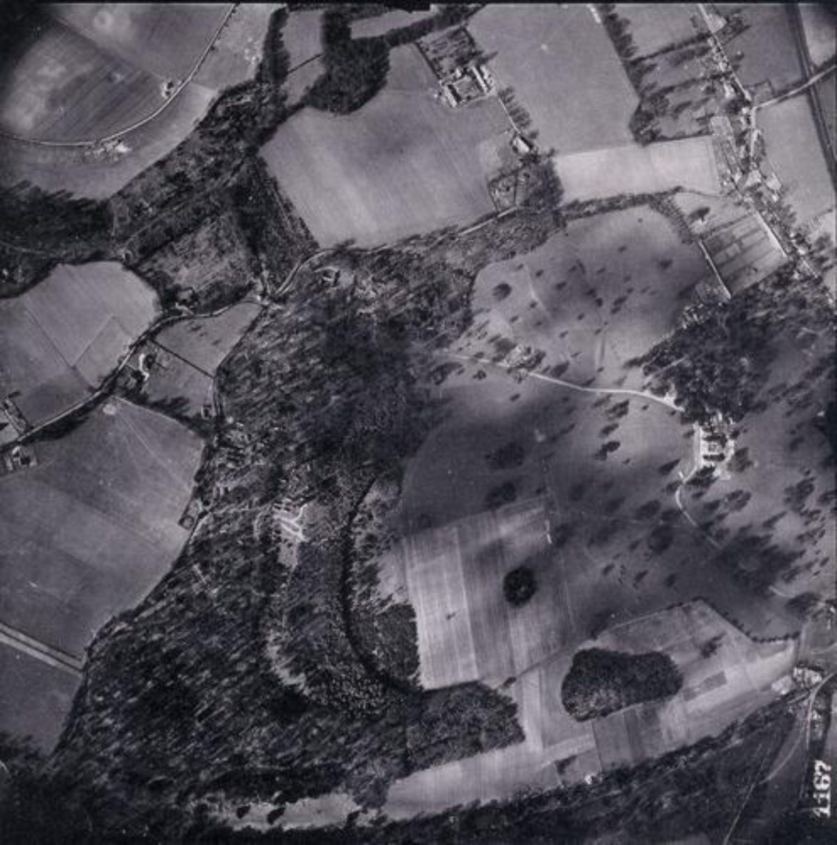
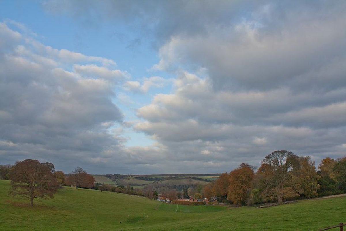
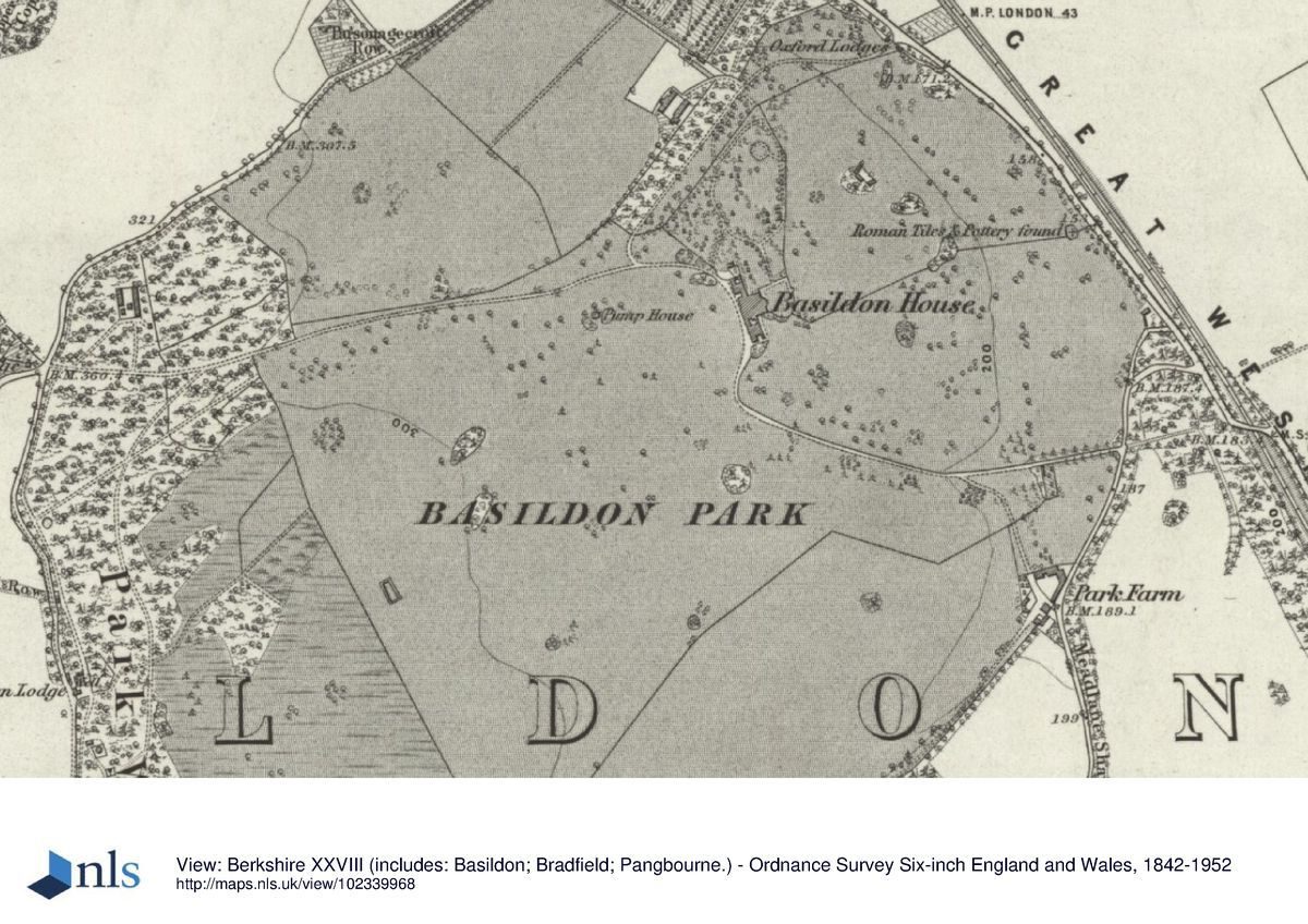
Basildon Park lies 3km south of Goring and Streatley and 3km north-west of Pangbourne, above the south bank of the River Thames. The 130ha site is bounded mainly by a brick and flint wall, ruinous on the south boundary, and beyond this largely by agricultural land and woodland. The A329 Wantage to Reading road runs along the north-east boundary; beyond this, open meadows, crossed by the railway, run north to the river. A green lane runs along the west boundary, adjacent to Park Wood, extending south off the lane between Upper and Lower Basildon which forms the north-west boundary. The house is set at the east end of a plateau which runs through the centre of the park south-west to north-east, with valleys to the north and south. The land drops away to the east, down to the river valley, with panoramic views across the river to the wooded hillside beyond. The setting is largely agricultural, with the village of Lower Basildon adjacent to the north and beyond this, 1km north of the house, the parish church standing close to the river, probably visible from the house before mature trees obscured the view.
Entrances and Approaches
The main approach off the A329 enters the park 300m north-east of the house, and is set back off the road between the Oxford Lodges (John Carr 1776-87, altered J B Papworth 1842, listed grade II*). The entrance to the north drive is flanked by iron gates supported by two stone gate piers topped by putti bearing urns with fruit, connected to the octagonal lodges by stone linking walls with pedestrian gateways. Flanking walls of stone and white brick extend north and south from the lodges for 50m. From here the north drive curves west and south-west up the hillside, through the pleasure grounds, turning east 100m west of the house to approach the west front via a broad gravel sweep overlooking the west park. The central door, situated on the first floor, is reached from the ground floor through the open arches of a loggia and up a double stairway to the open, two-storey portico where the main door leads into the house. A balcony runs along the open side of the portico, overlooking the west park.
The west drive enters the park 800m west of the house, off the Lower to Upper Basildon lane, past Godwin's Lodges (C18, listed grade II), standing on the opposite (west) side of the lane to the gateway. This substantial flint and brick building, largely in Gothic style with a Dutch-style gable on the east front, overlooks the gateway (mid-late C18, listed grade II) set into the boundary wall and flanked by broad brick and flint piers with urn finials supporting iron gates. The drive extends east from here, initially through Park Wood, emerging into the west park 500m west of the house, flanked by iron fencing, joining the north drive from the Oxford Lodges 100m west of the house. Two further lodges lie on the west boundary, south of the west drive. Coddesdon Lodge, of two storeys and built of flint and stone in Tudor style, stands 900m west-south-west of the house, giving access to Park Wood. Frying Pan Lodge stands 1.3km south-west of the house, giving access to the south-west corner of Park Wood.
The south drive, now disused, enters the park off the southern lane to Upper Basildon 450m south-east of the house, past Tower Lodge and through the adjacent gateway (mid-late C18, listed grade II). The octagonal, flint and rendered two-storey lodge lies to the south of the attached archway straddling the drive, both structures being in Gothic style. From here the drive extends west through the park ascending a hillside flanked by park trees, to turn north 50m south of the house, arriving at the west front.
Principal Building
Basildon Park (John Carr 1776-83, J B Papworth 1840s, listed grade I) stands towards the east side of the park, at the east end of a plateau, overlooking the river and hillside beyond to the north-east. The three-storey, Palladian stone house is centred on a rectangular main block flanked by screen walls (concealing service courts) leading to two smaller, pedimented pavilions. The long west entrance front is dominated by the two-storey raised and recessed portico reached from Carr's loggia below, whilst the east, garden front is dominated by the central projection of the Octagon Drawing Room overlooking the main terrace.
Carr's C18 stables stood in the park west of the house, possibly adjacent to the site of the old manor house (guidebook 1995), but were demolished in the 1840s, when Morrison employed C R Cockrell to replace them with a new block standing 250m north of the house (1843, listed grade II). Two single-storey brick blocks, reached via a spur south-west off the north drive, oppose each other across the stable yard. They are linked on their south sides by an arched gateway of brick and stone, and on their north sides by a brick and flint wall broken by a gateway flanked by brick piers.
Gardens and Pleasure Grounds
The formal gardens lie on the east front, the north end giving onto the wooded pleasure grounds connecting the house and stables.
A door at the centre of the east front, below the Octagon Drawing Room, gives access to the largely level square lawn lying on the main terrace to the east, bounded on the east side by a balustraded terrace walk (David Brandon c 1843) which stands above the park to the east. The terrace walk is reached from the east front by gravel paths along the north and south sides of the lawn which gradually rise to the east, each broken by central stone steps leading down to cross paths extending to north and south of the central lawn. The apsidal south side of the terrace extends into the park, overlooked from the west by a formal rose garden (Lady Iliffe, mid C20) lying at the foot of the south pavilion.
The lawn is connected to a croquet lawn to the north by the short gravel path along its north side, this extending north across the east side of the croquet lawn to the wooded pleasure grounds. The croquet lawn is edged to the west, east and south by flower borders. A gravel circuit path flanked by shrub beds (reinstated 1993-4) runs through the pleasure grounds, its eastern arm overlooking the park to the east. Some 200m north of the house the walk passes a raised grass platform on which stands a thatched umbrello (1990s) at the centre of the Morrisons' mid C19 former rose garden. The western edge of the area contains many mature, multi-stemmed Quercus ilex specimens set in lawn.
Until the early 1840s the park extended up to the east front, while a 'beautiful Lawn and Flower Garden' (1838 sale catalogue) of an irregular shape were concealed by trees to the north of the house, on ground sloping down to the north drive. These were described in the 1838 sale catalogue as 'most tastefully disposed with beds of the choicest Plants etc, and the walks shaded with highly ornamental Trees and Shrubberies' (quoted in guidebook 1995).
Park
The park encircles the house and pleasure grounds, and is divided into three sections. The western section, covered by Park Wood, is crossed by a network of paths, and contains the remains of Second World War Nissen huts used as a prisoner of war camp. At the north-west corner stands Timbers, a C20 house and garden set within the woodland. The other two sections of the park are open parkland laid to pasture, containing many mature specimen trees and clumps, largely oak, sweet chestnut, lime, beech and horse chestnut. The west park lies west of the pleasure grounds and south drive, and is crossed by valleys to the north and south connected by the plateau stretching west from the house. The old manor house stood towards the centre of the west park, with the C18 stables built close by (both now gone). Vestiges of two drives cross the north and south valleys, carried across the valley bottoms by earth causeways and believed to have been aligned on the site of the former manor house (Berkshire SAR). Views extend east across the river valley to the hillside beyond.
The east park, lying east of the pleasure grounds and north of the south drive, slopes down to the east, overlooking the Oxford Lodges to the north, with panoramic views over the river valley, and to the broad wooded hillside beyond.
Kitchen Garden
The 1ha, rectangular, brick-walled kitchen garden standing in the north corner of the park is now largely down to grass. An orangery (J B Papworth c 1843, listed grade II; now a house) stands at the south end of the north-west wall. Built of brick with three large arched windows set into the south-east side, this formerly overlooked the walled garden but is now enclosed within shrub planting. The shadow of former glasshouses is visible along the north-east wall. A walled glasshouse and frame yard formerly stood adjacent outside the south corner (OS 1912); the walls are now gone and the area is occupied by a car park.
In 1778 Sir Francis Sykes paid Lancelot Brown £52 10s, which accords with an entry in Brown's own account book mentioning 'Journeys and plans for kitchen garden, etc' (Stroud 1975). Little appears to remain of Brown's work within the walls, and no plan seems to have survived.
Maps
- J Rocque, Map of Berkshire, 1761
- T Pride, A topographical map of the Town of Reading and the County adjacent to an extent of 10 miles, 1790
- Map of Basildon, 1843 (Berkshire Record Office)
- OS 6" to 1 mile:
- 1st edition published 1877
- 2nd edition revised 1913/14
- OS 25" to 1 mile: 2nd edition published 1912
Description written: July 1998
Register Inspector: SR
Edited: March 2000, October 2022
- Visitor Access, Directions & Contacts
Telephone
441491672382Access contact details
Open March - December, 11am - 5pm. Closed Monday/Tuesday except Bank Holidays.
Visit the Basildon Park National Trust website for more detailed visitor information.
Last entry to site 1 hour before closing. Last entry to the house is at 4.15pm.
Directions
7 miles north-west of Reading on the west side of the A329. Please see:
Owners
National Trust
- History
The following is from the Register of Parks and Gardens of Special Historic Interest. For the most up-to-date Register entry, please visit The National Heritage List for England (NHLE):
16th - 17th Century
The part of the manor of Basildon now occupied by Basildon Park was owned by the Yonge family during the 16th and early 17th century, passing to Sir Henry Fane in 1680, in whose family the estate remained until the mid 18th century. At this time the manor house, possibly of Tudor origin, stood in what is now parkland; it is believed to have been situated west of the present house, although no visible trace remains of this structure (R Jordan-Baker pers comm, 1998). Sir Henry's grandson, the second and last Viscount Fane, may have been responsible for planting some of the trees in the park, together with the building of the gothic lodges on the west and south drives (guidebook 1995).
18th Century
By the mid 18th century (Rocque, 1761) most of the park had been laid out, except for the strip to the north of the west drive, with woodland bounding the western edge, and a house and related buildings had appeared on the site of the present house.
In 1771 Sir Francis Sykes (1732-1804), the youngest son of a Yorkshire yeoman, bought Basildon Park with the proceeds of his career from 1751-68 in the East India Company. Sykes was one of several `nabobs' living in the area, including Richard Benyon at Englefield and Warren Hastings who lived at Purley Hall during his impeachment by Parliament in the 1780s.
Sykes built a new house from 1776, probably extending the park at the same time to its present size, and employed Lancelot Brown (1716-83) in 1778 to design the kitchen garden, and possibly to advise on the park planting (guidebook 1995).
19th Century
The Sykes family sold the estate to a Liberal MP, James Morrison, in 1838. Morrison completed rooms left unfinished by Sir Francis and built the main garden terrace, having received advice from William Andrews Nesfield (1793-1881) and Edward Kemp (1817-91), finally employing the architect David Brandon to construct it.
20th Century
The estate remained in the Morrison family into the 20th century, although unlived in by the family from 1910 and gradually falling into disrepair. It was bought in 1952 by the Hon Langton Iliffe, later Lord Iliffe, and his wife. They restored the house and park, giving the estate, now open to the public, to the National Trust in 1982.
Period
18th Century (1701 to 1800)
- Associated People
- Features & Designations
Designations
The National Heritage List for England: Register of Parks and Gardens
- Reference: GD1571
- Grade: II
Features
- Lawn
- Shrub Border
- Croquet Lawn
- House (featured building)
- Earliest Date:
- Key Information
Type
Park
Purpose
Ornamental
Principal Building
Domestic / Residential
Period
18th Century (1701 to 1800)
Survival
Extant
Hectares
130
Open to the public
Yes
Civil Parish
Basildon
- References
References
- {English Heritage Register of Parks and Gardens of Special Historic Interest} (Swindon: English Heritage 2008) [on CD-ROM] Historic England Register of Parks and Gardens of Special Historic Interest
- Stroud, D {Capability Brown} (1975) p 217 Capability Brown
- Pevsner, N. {The Buildings of England: Berkshire} (Harmondsworth: Penguin, 1966) pp 76-78 The Buildings of England: Berkshire
- Rutherford, Sarah {Basildon Park Framework Garden Conservation Plan} (2006) Basildon Park Framework Garden Conservation Plan
- (1923), pp 457-61 Victoria History of the County of Berkshire 3
- (National Trust Classics 1990), pp 111-13 In Search of English Gardens: The Travels of John Claudius Loudon and his wife Jane
- Vol 161, (5 May 1977), pp 1158-61; (12 May 1977), pp 1227-30 Country Life
- Guidebook, (National Trust 1995) Basildon Park