
Introduction
Abbey House has associated gardens which have recently been restored following a grant from the Heritage Lottery Fund. The house over looks Whitby Abbey ruins.
Terrain
Steeply sloping to the west and south.
The following is from the Register of Parks and Gardens of Special Historic Interest. For the most up-to-date Register entry, please visit The National Heritage List for England (NHLE):
Gardens laid out in the early to mid-17th century and during the period around 1670-1700, possibly incorporating part of a 16th-century layout.
Location, Area, Boundaries, Landform and Setting
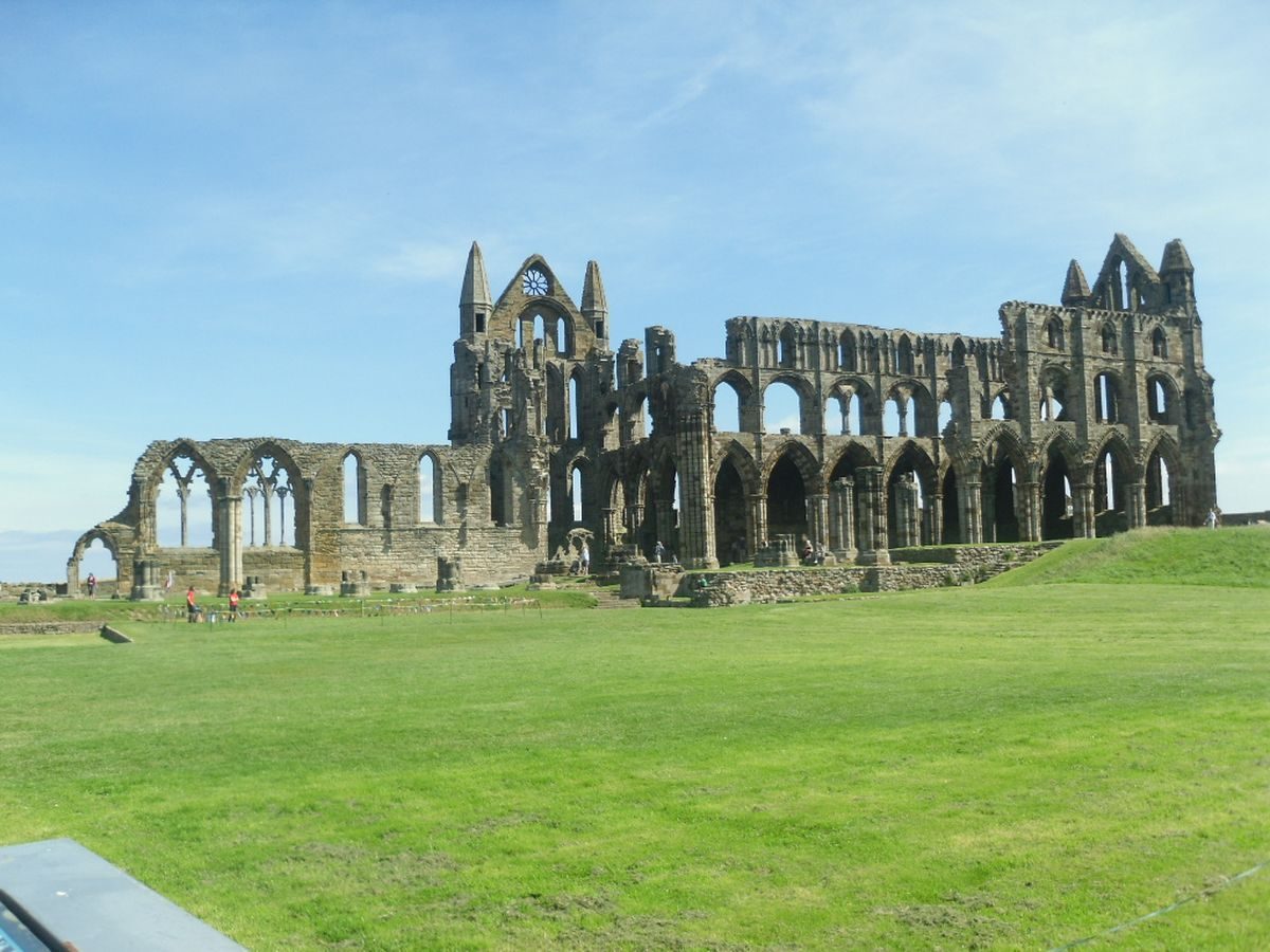
The c 3.5 ha site lies on a headland above the River Esk and the town of Whitby, immediately to the south-west of the ruins of Whitby Abbey Church. The land slopes steeply down to the west and to the south. The boundaries are formed by walls on the west and north sides, and the medieval monastic ditch and bank to the south. On the east side the boundary follows the lines of walls shown on a map of c 1670-1745, largely visible as the edges of platforms in an area of grassland south of the Abbey Church.
Entrances and Approaches
The entrance to the site is from the north where there is a C19 gatehouse with an arch which leads into the east side of Outward Court where a path continues down the east side of Inward Court and the New House into a courtyard on the south side of the building. This approach was created in c 1866 by Charles Strickland who demolished a medieval building called the Old Vault on the east side of New House to give access to the Abbey House behind it. A set of C17 cruciform stone gate piers (listed grade I with the garden walls) flanking a blocked opening stand at the centre of the north wall of Outward Court and mark the main entrance to the site in the C17 and C18. A cobbled drive (partially exposed by archaeological excavation, 1998) leads from this entrance to the Stable Yard on the west side of the Court and from the cobbled roadway a drive paved with stone flagging runs southwards to a secondary entrance, aligned with the front of New House, in the former north wall of Inward Court.
Principal Building
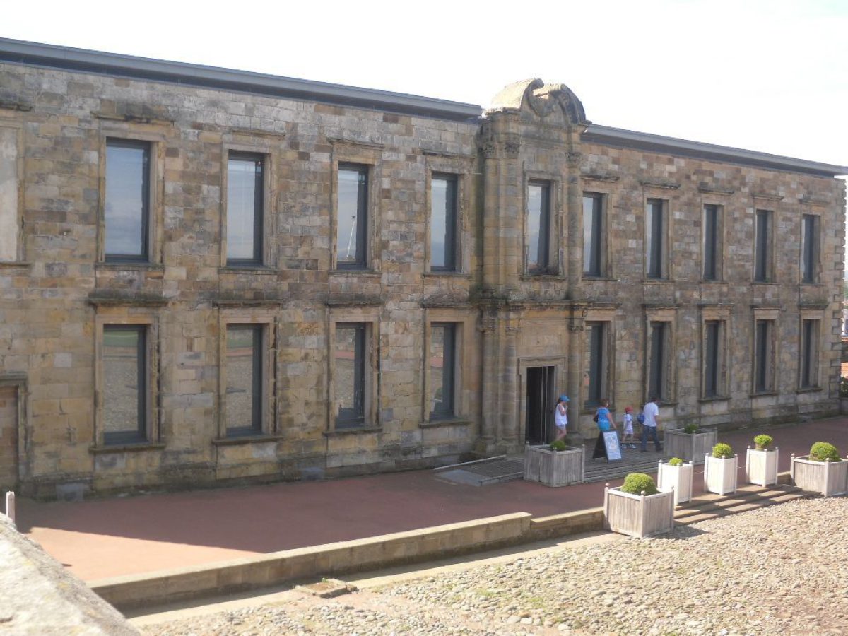
The Abbey House (listed grade I) originated as a monastic building which was granted to the Cholmley family in 1541 and purchased by them in 1545. Various building works were carried out up until 1669 when the second Sir Hugh Cholmley, son of the first, built a new house on the site during the period c 1669-1672. This building, known as the New House (also called the Banqueting House from the late C19 onwards and listed grade I with Abbey House), was erected north of the Abbey House and was linked to it on the east and west sides, creating a courtyard between the two buildings. New House is a building of some architectural ambition with a central entrance in the north front flanked by two tiers of columns surmounted by a broken pediment.
New House was severely damaged by gales in 1790 and was never re-roofed. The Abbey House was only occupied intermittently thereafter until Sir Charles Strickland started to make alterations in the 1860s. The Abbey House was leased to a holiday association for use as a hotel in 1896, in which use it remains, and the New House is in the guardianship of English Heritage. The building has recently (2003) been restored and a visitor centre constructed within it.
A complex of buildings (listed grade I) lie c 100 m north-west of the Abbey House complex, ranged along the west side of Stable Yard. They are on the site of buildings called `New Stables' on the map of c 1670-1745. The northern part of this range is a single-storey building extensively altered and restored during the C20 and in use as a Youth Hostel (2003). Attached to the south are two buildings, one incorporating medieval material and the other extensively rebuilt in the mid C20, which are in use as separate private residences.
Gardens and Pleasure Grounds
The Abbey House complex lies at the centre of a series of enclosures and former enclosures which are shown on an undated vellum map of the period c 1670-1745. This has been shown to be approximately accurate and the high standard of draughtsmanship suggests it is probably the work of an architect or surveyor. For the sake of clarity the names used here for different parts of the garden will be those shown on this map though modern spellings are used. The gardens and the Abbey House were laid out over an existing system of medieval terraces running north to south down the side of the headland and the changes in level reflect the way in which these terraces were exploited and modified.
Two courtyards are aligned with the north side of New House. Outward Court is walled and the c 1670-1745 map shows buildings, each one marked Porter-s Lodge, within the north-west and north-east angles of the wall. Gate piers with ball finials flank an opening in the west wall leading into the Stable Yard. A wall between the Outward Court and the Inward Court survives as footings and there are settings for central gate piers on each side of a stone-flagged driveway leading into the Inward Court.
Inward Court is of rectangular plan with a central cobbled courtyard and raised alleys on each side. The courtyard has a pattern of north to south lines at regular intervals picked out in large cobbles and there is a central rectangular area containing stone foundations. An account written in 1682 by Ralph Thoresby (quoted in Hunter 1830) describes the courtyard with `a curious structure in solid brass as large as life' and schematic indications of a statue in the centre of the Inward Court are shown on a number of C18 maps. A rectangular feature with apsidal ends is shown on the c 1670-1745 map and this could have been a plinth for the statue.
The outer edge of the cobbled area was lined with stone flags and the alleys are supported by stone revetments, the robbed remains of which have been exposed by excavation. The foundations of a small building in the north-west corner of the courtyard have also been exposed. Central steps (partially demolished) lead down from New House to the alley, and footings for stone steps up to the alleys survive on each side of the entrance from Outward Court. This layout, including the steps and alleys but not the garden building, is shown on the c 1670-1745 map. The east wall of the courtyard, which is a retaining wall built along the modified line of a medieval terrace, has a parapet incorporating three plinths, one at each end and one in the centre, which are shown on the c 1670-1745 map and were probably used to support statuary.
The Stable Yard, a courtyard situated on the west side of the Inward and Outward Courts, is divided into areas of grassland and private gardens. Part of a stone wall divides the Stable Yard from a grassed area to the south, called The Grove, which lies immediately to the west of New House and enjoys long views over Whitby and the Esk Valley. In the south-west corner of The Grove are the remains of a brewhouse which is shown on the c 1670-1745 map.
The Grove is divided from the kitchen garden, which lies to the south, by the remains of a walled passageway connecting The Grove to the Drying Yard on the south side of Abbey House. The passage is shown on the c 1670-1745 map with a privy with two rows of seats in it.
Immediately south of the Abbey House and east of the kitchen garden there are two walled enclosures. That to the west is called the Drying Yard and it connects with the passage from The Grove and with a similar passage running east to west along the southern end of the site. The Drying Yard is an irregular sub-rectangular area with the remains of a small stone building of unknown date at its south end. It is shown on the c 1670-1745 map at which time it did not extend so far south. It appears in its present form on the 1851 OS map.
Immediately east of the Drying Yard, the Parlour Yard is a rectangular enclosure with a steep grassed bank running along its east side. The area is grassed and has late C20 flower beds south of the Abbey House. Archaeological excavation has shown that the foundations of a wall lie beneath the bank, corresponding with the position of the east wall of the Parlour Yard on the c 1670-1745 map.
The footings of another, earlier wall were found running from east to west across the garden c 20m south of Abbey House. This wall is not shown on the c 1670-1745 map and must relate to an earlier garden or structure. The map shows two buildings marked the `Parler' and the `Still House' immediately east of the present Abbey House frontage of which no visible traces remain. This area almost certainly corresponds with a place `made fit under parlour side to set more vines' mentioned in the second Hugh Cholmley's memoirs for 1670/1 (Cholmley 1787).
The gardens on the east side of the site survive as earthwork remains. Owing to the combination of the natural slope and the medieval and post-medieval terracing they are at a high level, corresponding to approximately first-floor height of New House, and they enjoy long-distance views to the west and south-west over the Esk valley.
The northernmost part of the upper gardens is a level platform called High Yard. This corresponds approximately with the extent of Inward Court, from which it is divided by the retaining wall with plinths. The area is shown as a walled, approximately square enclosure on the c 1670-1745 map which could be reached from the doorway in the upper floor of the east elevation of New House, but it is not clear exactly how access was gained owing to the C19 demolitions and additions to this area.
South of High Yard there is a sunken garden called Middle Yard, overlooked from the east side by a long narrow walkway called the Long Walk. A ramp running east to west into Middle Yard is not shown on the c 1670-1745 map and it could have been constructed to give access to the gardens on this side following the abandonment of New House in c 1790. To the east of the Long Walk and High Yard there is a levelled platform which is shown as a walled enclosure on the c 1670-1745 map and marked `The Grove for Fir Trees'. The approximate edge of the area is shown on some C18 maps, but no planting is indicated on any of the known C18 or C19 maps of the area.
The first-floor access to these raised gardens from New House emphasises the fact that they must have been exclusive private areas kept for the use of the family, and distinct from the entrance areas (Inward and Outward Court) and the utilitarian Stable Yard, Drying Yard, and Kitchen Garden.
It is possible to relate the formation of the Inward and Outward Courts to the construction of New House in 1669-72 but the development of the other parts of the garden complex is obscure. In 1634 the first Sir Hugh Cholmley mentions works of heightening the outer walls of the court and making walls around a paddock in his memoirs (Cholmley 1787) and an inscription recorded in 1860 (Robinson 1860) stated that he and his wife had `built this wall and planted this orchard' but it is not known to which area this referred.
Kitchen Garden
South of The Grove and west of the Drying Yard there is a large walled enclosure on land which falls to the south which is in use as allotments (2003) and is marked Kitchen Garden on the c 1670-1745 map. An entrance from the south end of The Grove leads to a set of stone steps running down into the garden. The garden is divided into three areas laid out on two levels, with a level upper area in the north-east corner separated from gardens sloping to the south by brick retaining walls.
The lower gardens are divided by a brick wall running north to south with an arched opening at the south end. Against the wall immediately west of the entrance steps there are the remains of a heated wall and the footings of a glasshouse, possibly identifiable with a building shown in this position on Wood's map of 1828. An opening in the south-west corner of the garden leads to a path running alongside the west wall of the complex, while another path leads to the south side of the kitchen garden where there are allotments alongside the south kitchen wall which were established by 1820.
Maps
(All reproduced in WAHP 1997)
- Plan of house and gardens at Whitby, nd (c 1670-1745)
- J Wood, Plan of Whitby and environs from an actual survey, 1828
- OS 25" to 1 mile: 1st edition published 1894
- OS 5' to 1 mile: 1st edition published 1852
Description written: December 1998
Register Inspector: CH
Edited: October 2004
- Visitor Access, Directions & Contacts
- History
The following is from the Register of Parks and Gardens of Special Historic Interest. For the most up-to-date Register entry, please visit The National Heritage List for England (NHLE):
AD - 11th Century
Whitby Abbey was founded in AD 657 by Hild, Abbess of Hartlepool. It was overwhelmed by Danish invaders in about AD 867 and the abbey was not re-established until around 1078.
13th Century
The present remains of the Abbey Church (scheduled ancient monument, listed grade I) date largely from the 13th century.
16th - 19th Century
The abbey was dissolved in 1539 and the site was leased to and subsequently bought by Richard Cholmley, who was knighted in 1544.
The site remained in the Cholmley family until 1791 when it passed by marriage to the Fane family, and in 1866 to Sir George Charles Strickland. It subsequently passed to the Strickland Constable family and the site was split up in 1896, with part of it being leased to a holiday association.20th - 21st Century
During the 1930s further parts of the site were disposed of in leasehold arrangements. The ruins of the Abbey Church and the New House were taken into government guardianship, subsequently passing to English Heritage, in whose care they remain (2003). Other parts of the site are in mixed private, corporate, and public ownerships.
- Features & Designations
Designations
The National Heritage List for England: Register of Parks and Gardens
- Reference: GD4353
- Grade: II
The National Heritage List for England: Listed Building
- Grade: I
Scheduled Ancient Monument
- Reference: Abbey Church
Features
- Ditch
- Description: The boundary is formed by the medieval monastic ditch and bank to the south.
- Key Information
Type
Garden
Purpose
Ornamental
Principal Building
Domestic / Residential
Survival
Extant
Hectares
3
Open to the public
Yes
Civil Parish
Whitby
- References
References
- {English Heritage Register of Parks and Gardens of Special Historic Interest}, (Swindon: English Heritage, 2008) [on CD-ROM] Historic England Register of Parks and Gardens of Special Historic Interest
- Thoresby's Diary
- History of Whitby
- Memoirs of Sir Hugh Cholmley I,
- Memoirs of Sir Hugh Cholmley II
- Whitby Abbey Headland Project