Introduction
The Workhouse, Southwell, is a well-preserved example of an early-19th-century workhouse, now open to the public as a museum. The grounds, reduced in size from the original, feature a reconstructed early 19th-century garden, where the paupers grew fruit and vegetables.
Terrain
The site falls gently from north to south towards the River Greet which runs close to the south of the site.
The following is from the Register of Parks and Gardens of Special Historic Interest. For the most up-to-date Register entry, please visit the The National Heritage List for England (NHLE):
www.historicengland.org.uk/listing/the-list
The grounds of an early 19th-century workhouse opened in 1824, designed by the architect William Nicholson following instructions from the Rev John Thomas Becher. Its deterrent system was widely disseminated, being published by Becher in The Anti-Pauper System (1828) together with a plan of the layout, and both the system and plan became influential on other workhouses.
DESCRIPTION
LOCATION, AREA, BOUNDARIES, LANDFORM, SETTING
The c 2.5ha site lies 1.5km east of the centre of Southwell on the north side of the main A612 Southwell to Newark road. The site falls gently from north to south towards the River Greet which runs close to the south of the site. The north-east side is bounded by Greet House, a residential home built in 1926 as a new infirmary occupying part of the former gardens of the Workhouse, and to the north of this by the road to Normanton. To the north-west it is bounded by a lane linking the Southwell to Newark Road with Normanton Road, and to the south-east by the grounds of Caudwell House, a children's home (1937) set in a block of land which was probably formerly used as agricultural land by the Workhouse. The south side of the site is bounded by the A612. Most of the boundary is marked by a clipped hedge. The setting is rural, with close by to the north-west the grounds of The Hall, whose south-east shelter belt of trees partially screens the Workhouse site. Views extend north-west towards The Hall and its grounds, south-west towards Southwell and its Minster, and south and south-east towards distant low hills.
ENTRANCES AND APPROACHES
The site is approached from the south-west off the A612 via a pedestrian gateway (replaced 2001) at the south-west tip of the site, giving access from Southwell and Newark. From here a path leads north-east through a newly created (2001) car park, then across the centre of a field towards the centre of the south-west front of the main building. Some 50m south-west of the main building the path is flanked by a clipped beech hedge which divides the field from an area of orchard lying adjacent to the building and yards. The path arrives at the central entrance to the Workhouse building, flanked by two brick walls of the first-class male and female paupers' exercise yards arranged in such a way as to funnel the path in to the front door. The building is approached via a short flight of stone steps leading to the stone-clad front doorcase. This was the original entrance for the governing committee and governor and other important visitors. It appears that formerly there may have been a wall or fence enclosing the area immediately in front of the main entrance, linking the walls of the exercise yards and thus creating a small forecourt (OS 1898, 1915).
Two further entrances, off the lane to the north-west, give access to the northern end of the site and the service yards on the north-east side of the main building. The southern entrance off the lane gives access to two entrances in the brick wall at the north corner of the north-west yard, and at the east corner of the south-east yard, these having been designed for use by the pauper women and men respectively. These entrances into the service yards became disused at some point in the C19 (plan, in Becher 1828; OS 1898), and they have recently (2001) been reopened. It appears that the approach for paupers was intended from the early C19 (Sanderson, 1835) to have been along this lane or off Normanton Road, rather than via the central path. The northern entrance off the lane provides access into a later, outer service yard dividing the service range adjacent to the main building from the 1926 infirmary known as Greet House to the north-east. This yard is bounded to the north-west by a stable and mortuary block of the 1920s, the 1820s' service range to the south-west, the 1871 Infirmary to the south-east, and Greet House (1926) to the north-east.
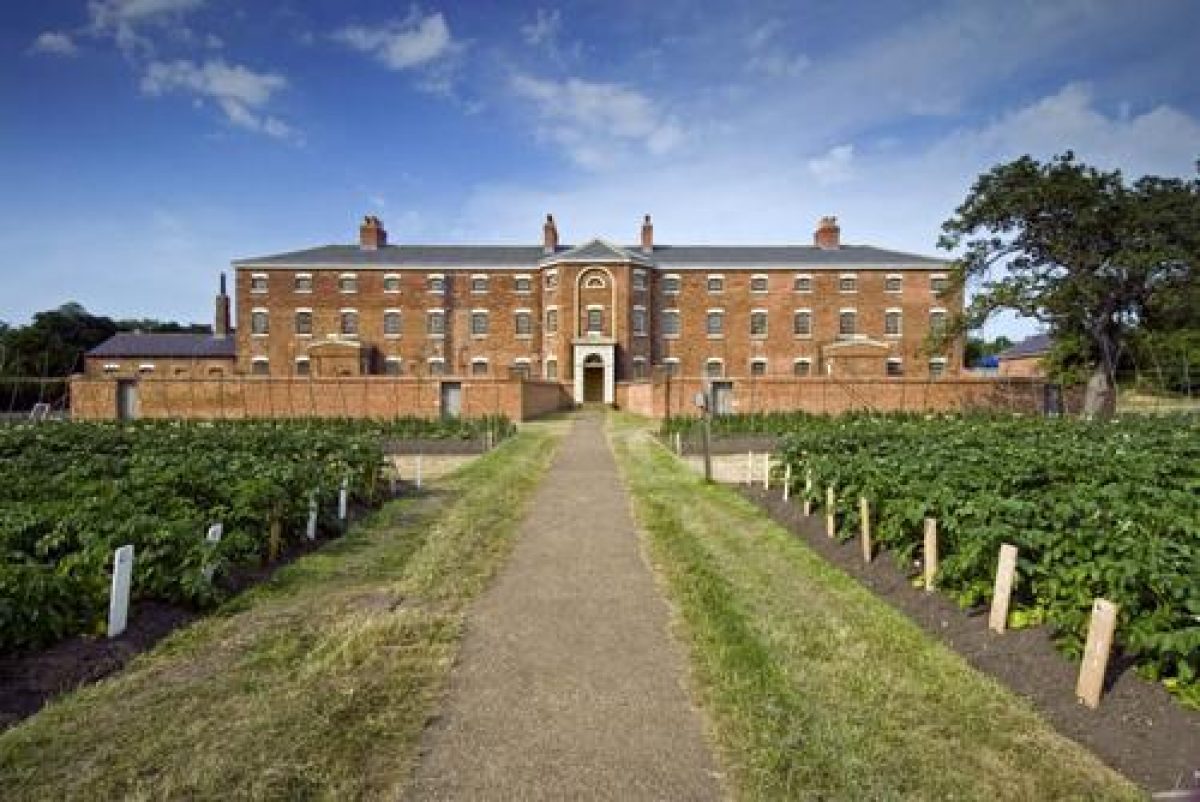
PRINCIPAL BUILDING
Thurgarton Hundred Workhouse (listed grade II*) stands towards the centre of the site. Built in 1824 to a design by the Rev Becher, assisted by the architect William Nicholson, it comprises three storeys with cellar, of red brick. Three ranges emanate from a central octagonal hub which contains the committee room on the ground floor, and the accommodation for the governor on the first and second floors. The windows of the committee room and governor's apartment in the hub overlook the four separate exercise yards on the south-west front, aiding inspection. The central position of these rooms also meant that the governor had equal access to the three wings which were assigned to men (south-east), women (north-west) and children (north-east). Within their accommodation men and women were divided into first- and second-class inmates as defined by Becher: respectively those of 'good character and conduct' (in practice the elderly) and those deemed 'idle, immoral and improvident' (in practice the able-bodied). The accommodation for each class included day rooms (ground floor), dormitories (first and second floors), staircases, and yards, and was intended to segregate them in order to prevent mixing. Views extend south-west from the two upper floors towards the River Greet and Southwell Minster, but are partially obscured from the ground floor by the walls of the exercise yards.
To the north-east of the main building, separated by the two service yards lying side-by-side, stands a range of service buildings (1824), the north-west half having recently (2001) been rebuilt. These contained an infirmary, isolation cell for refractory paupers, cow house, stable, bathhouse, washhouse, and bakehouse. Parts have been converted for office use. Further north, adjacent to the north-west boundary, stands a mortuary and stable block (early C20), with, opposite, against the south-east boundary, the 1871 infirmary. This two-storey red-brick building faces north-west into the outer service yard.
The annotated layout of the Workhouse was published by Becher (1828) and influenced the design of new workhouse buildings at Stoke-upon-Trent, Staffordshire, and Ongar, Essex. The Thurgarton system was implemented at other existing workhouses, including Uley, Gloucestershire, St Werburgh, Derby, and Penzance and Redruth in Cornwall (Morrison 1999).
GARDENS AND PLEASURE GROUNDS
The grounds were not laid out primarily for ornament, but for productive purposes and to provide exercise for the pauper inmates. To achieve these aims the grounds were divided into two main areas: the paupers' enclosed exercise and service yards situated adjacent to the main building, and the productive land beyond.
The yards attached to the main building date from the 1824 phase and are divided into two main sections: those to provide exercise and fresh air which occupy the south-west front of the main building, and those on the north-east front, which accommodated service activities. The four main exercise yards occupy the whole of the south-west front, from which they are entered and overlooked. Windows in the west and south sides of the octagonal hub, situated in the committee room and governor's bedroom, give views of all four yards. They are surrounded on three sides by c 2m high brick walls, and on the fourth, north-east side by the main building, from which each one is entered via a door at ground-floor level, which is above yard level. The doorways are paired in small porches which give direct access from the staircases and day rooms of the respective classes of inmate. Two yards each were allocated for females and males, to the north-west and south-east of the main entrance respectively, mirroring their accommodation in the building. The second-class paupers (ie those deemed idle, immoral and improvident by Becher, and largely comprising the able-bodied) used the outer yards, and the first-class paupers (ie those deemed by Becher to be of good character and conduct, and comprising largely the elderly) used the inner two yards which are somewhat larger. Each yard contains a semicircular privy, standing attached to the south-west boundary wall. The south-west, outer wall of each yard contains a doorway giving access to the orchard and field beyond. Elements of the walls and privies have recently (2001) been rebuilt while the exercise yards have been relaid to asphalt, following archaeological excavation which indicated that this was the surfacing material towards the end of the C19.
Two larger, rectangular service yards occupy the north-east front of, and are overlooked by, the main building. They are divided by the third wing, which housed children, and bounded by the service range to the north-east and brick walls to the other two sides. These yards have also been laid to asphalt, the late C19 surfacing material, and a pump stands at the centre of each one.
A single-storey extension is attached to the north-west front of the main building; this may have been a schoolroom. A doorway from this opens to the south-west into a further yard, lying adjacent to the second-class females' yard, which is surrounded by 2m high iron fencing.
The 1871 infirmary, standing to the north-east of the main building, is set in its own grounds, on land formerly worked by the inmates. The building is approached from the outer service yard to the north-west, and is fronted by two exercise yards bounded by low brick walls which formerly supported iron railings, elements of which remain in places. The yards are laid to lawn, planted with several mature specimen trees, and each is enclosed by a perimeter path. To the rear, south-east, of the building are further enclosed service spaces and buildings, lying adjacent to the site boundary.
KITCHEN GARDEN
The inmates were intended to be supported largely by the work of the able-bodied paupers. To this end the attached ground to the south-west and to the north-east, together with further adjacent land (outside the area here registered) was given over to productive crops which they worked. Currently (2002) the c 2ha to the south-west is divided into two main sections. That closest to the main building, divided from the field beyond by the clipped beech hedge, contains several mature fruit trees, with a path running from north-west to south-east along the bottom of the airing-yard wall, and two spurs leading south-west off this. These appear to be the remains of paths shown on a map of 1929 (NCC) when the ground was divided into rectangular quarters of various sizes flanking the main approach path. South-west of the beech hedge, the field, enclosed by clipped hedges and bisected by the main approach path, has recently been reseeded and a tarmac car park laid out at the south-west boundary. This area was in recent times (late C20) a nursery, with nursery buildings occupying the area now (2002) used as a car park (National Trust 1999).
REFERENCES
Rev J T Becher, The Anti-Pauper System, Exemplifying the Positive and Practical Good realised by the Relievers and the Relieved under the Frugal, Beneficial and Lawful Administration of the Poor Laws Prevailing at Southwell (1828; 2nd edition 1834)
CKC Archaeology, Archaeological excavations in the garden area, Thurgarton Workhouse, (report for National Trust, February 1999)
K Morrison, The Workhouse, a study of Poor-Law buildings in England (1999), pp 36-42, 208, 231
National Trust, The Workhouse, Southwell Garden Conservation Plan, (unpublished report, March 1999)
Description written: January 2002
Amended: April 2002
Edited: April 2002
- Visitor Access, Directions & Contacts
Telephone
0844 800 1895Website
http://www.nationaltrust.org.ukAccess contact details
The site is open Wednesdays to Sundays 12 until 5 pm between March and October.
Directions
The Workhouse lies between Nottingham and Newark on the A612.
Owners
The National Trust
Heelis, Kemble Drive, Swindon, SN2 2NA
- History
The following is from the Register of Parks and Gardens of Special Historic Interest. For the most up-to-date Register entry, please visit the The National Heritage List for England (NHLE):
www.historicengland.org.uk/listing/the-list
HISTORIC DEVELOPMENT
In 1808 a workhouse was erected in Southwell for eighty-four pauper residents of the parish. It had been designed by the Rev John Thomas Becher of Southwell, and was, as Becher maintained, 'constructed and governed upon a principle of Inspection, Classification, and Seclusion' (Becher 1828). In 1824 the parish became part of the newly formed Thurgarton Hundred Incorporation, comprising forty-nine parishes around Southwell. The general intention was to operate a deterrent system of institutional care modelled on that of Southwell, based on strict economy and supervision 'tempered with tenderness towards the Infirm and Guiltless Poor, but opposing by every legal effort the overwhelming Advances of idle, profligate, and sturdy Pauperism' (Becher 1828); in other words, to deter the pauper population from becoming a financial burden on the rate-payers. To accomplish this a larger workhouse was erected within its own spacious grounds at Upton, on the outskirts of Southwell. Designed by Becher, assisted by a local architect, William Nicholson, it cost £6596 and could hold 158 paupers. It became an important forerunner of the radially-planned workhouses erected as a result of the passing of the New Poor Law (1834).
The Upton Enclosure map (1795) shows a series of roughly rectangular plots laid out parallel on an island surrounded by three roads. The Workhouse and its immediate grounds subsequently occupied the westernmost of these plots, approximately 6 acres (2.5 hectares). Sanderson's plan (1835) shows the Workhouse, its yards, and service buildings occupying the centre of the plot, with an axial drive leading from Southwell Road north-east to the centre of the south-west front of the building, and with a further path indicated leading north-east on the same line, from the north-east side of the building to Normanton Road. An inventory of 1837 stated that the field on which the Workhouse stood comprised 6 acres 0 roods and 26 perches (about 2.5 hectares), and that on the south side of the building approximately 1 acre 2 roods and 0 perches of land (about 0.5 hectare) were cultivated by the spade for the use of those in the 'house'. Some 2 acres (about 0.8 hectares) of the remaining land to the south was laid to grass and let out. The land to the north of the Workhouse was cultivated 'by the spade for potatoes for the use of the House' (National Trust 1999). The male paupers undertook most of the work on the land. In the 1834 edition of his pamphlet, Becher advocated that the paupers should undertake tasks such as 'Spade Husbandry, dibbling seed corn, weeding, or any similar occupations; all which should be executed as Taskwork, by the Piece'. A wide variety of fruit and vegetable crops were grown, as listed in the accounts of 1825 (NRO), and included box plants for edging. Milk cows also appear to have been kept. The site continued in use during the rest of the 19th and early 20th century, becoming a residential home for the elderly in the 1950s; this was closed in the late 20th century. The site was purchased by the National Trust in 1997, and has undergone major restoration prior to opening to the public in 2002.
- Features & Designations
Designations
The National Heritage List for England: Register of Parks and Gardens
- Reference: GD5070
- Grade: II*
Features
- Workhouse (featured building)
- Earliest Date:
- Latest Date:
- Hedge
- Description: Most of the boundary is marked by a clipped hedge.
- Key Information
Type
Garden
Purpose
Ornamental
Principal Building
Heritage Site
Survival
Reconstructed
Hectares
2.5
Open to the public
Yes
Electoral Ward
Southwell East
- References
References
- {English Heritage Register of Parks and Gardens of Special Historic Interest}, (Swindon: English Heritage, 2008) [on CD-ROM] Historic England Register of Parks and Gardens of Special Historic Interest