Introduction
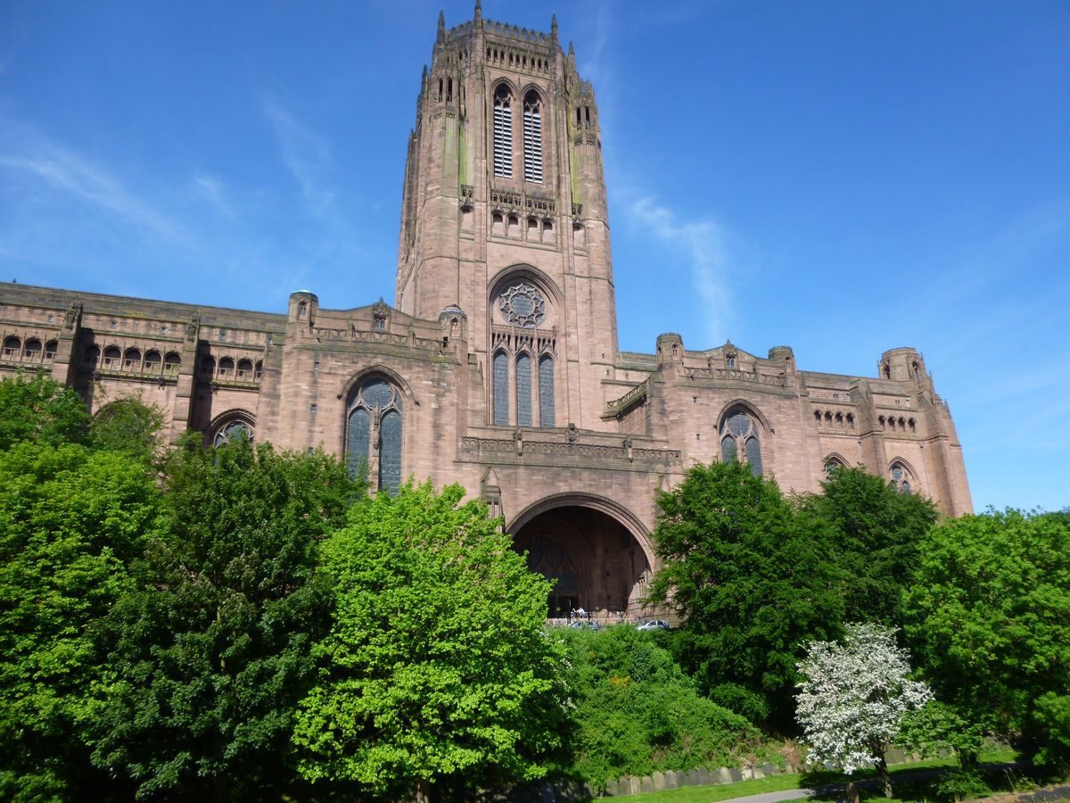
St James' Cemetery is an early-19th-century cemetery laid out in a former quarry in the shadow of the Anglican Cathedral. It was converted to a public park in the late-1960s, following the last interment in 1936. The cemetery architect was John Foster and the landscaping was by John Shepherd, the curator of the Botanic Garden in Liverpool.
Terrain
The site is surrounded by high ground rising from the River Mersey to the west.The following is from the Register of Parks and Gardens of Special Historic Interest. For the most up-to-date Register entry, please visit The National Heritage List for England (NHLE):
A cemetery developed by a private company and opened in 1829, with architectural features designed by John Foster and landscaping by John Shepherd.
Location, Area, Boundaries, Landform and Setting
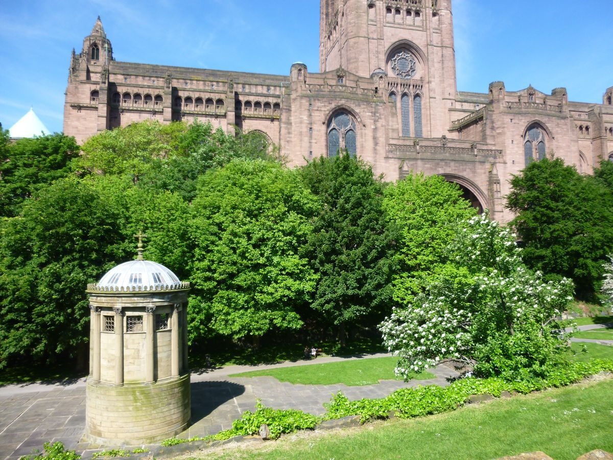
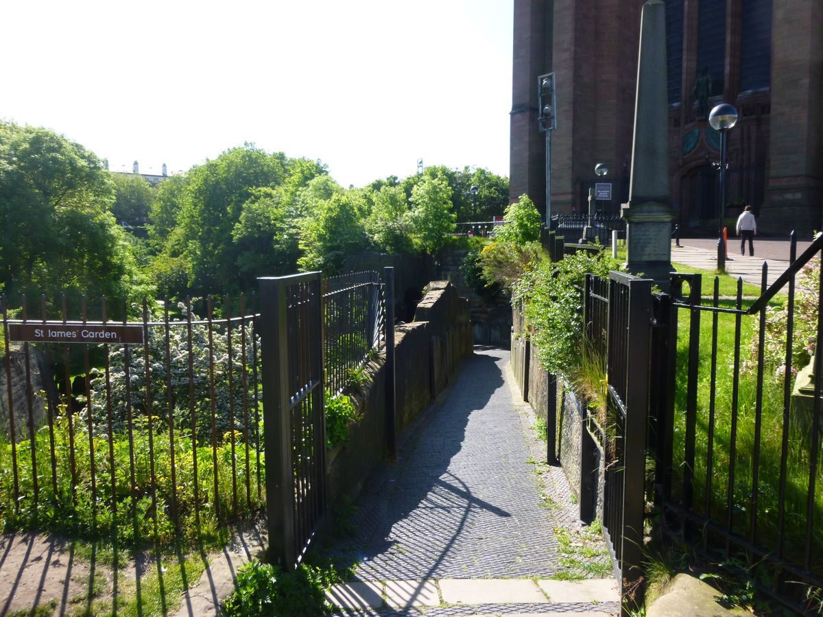
The c 4ha cemetery is located c 1km south-south-east of Liverpool city centre and is surrounded by high ground rising from the River Mersey to the west. To the west the cemetery adjoins the precinct of the Anglican cathedral and St James's Mount, both sited on high ground above the former quarry. The boundary to the cathedral precinct, at the head of a steep wooded slope, is generally marked by C20 security fencing, with C20 railings adjacent to the north cathedral entrance. Some 125m north-north-east of the principal entrance at the south-west corner, a line of railings runs from west to east down the wooded slope terminating at a low stone pier. From this pier a low stone wall, now lined with resited gravestones, appears to run north at the base of the wooded slope and may indicate an alteration of the cemetery boundary to this line in the early C20, with the wooded slope incorporated into the cathedral precinct.
To the north the cemetery is bounded by Upper Duke Street, to the east by Hope Street, and to the south by Upper Parliament Street. These boundaries are generally marked by low stone walls topped with C20 railings. From the east and north road boundaries there are views down into the cemetery below. At the north-west corner of the site the former mortuary chapel, the Oratory, is bounded to the north by Upper Duke Street and to the west by a C20 hard landscaped forecourt adjoining Cathedral Gate (formerly part of St James' Road, now realigned). Boundaries adjoining the Oratory are marked by a low stone walls topped with cast-iron railings set between panelled stone piers (1829, the whole listed grade II).
Immediately to the south of the cathedral, and to the south-west of the cemetery, lies St James's Mount (outside the area here registered), which is laid out with grass paths edged with hedging and stonework on shallow terraces descending to the east. To the east of St James's Mount a wide grass path runs c 80m from north to south to where stone steps lead down to the forecourt adjoining the principal cemetery entrance. This path is edged with low stone walls partially topped, to the west, with C19 railings marking the boundary at the head of a steep grassed embankment. This path, which commands long views to the west over the River Mersey, forms the remnant southern third of St James's Walk (Eyes, 1785) laid out in 1767.
The boundary between the cemetery and St James's Mount to the west is marked by a further grassed path at the head of a wooded slope, with, to the east of the path, a low stone retaining wall at the head of the slope. A small number of gravestones to the edge of the grass path indicate that this area may have been used for burials. This grass path was formerly a carriageway which ran at the higher level along the west side of the quarry and served properties situated at the northern end of St James's Mount (Horwood, 1803) which remained after the formation of the cemetery (Bennison, 1835; OS 1891).
The immediate surrounding area is largely residential with large C19 terraced housing on Hope Street to the east and late C20 housing beyond the cathedral to the west. To the north-east of the cemetery the predominant use is for higher education facilities.
Entrances and Approaches
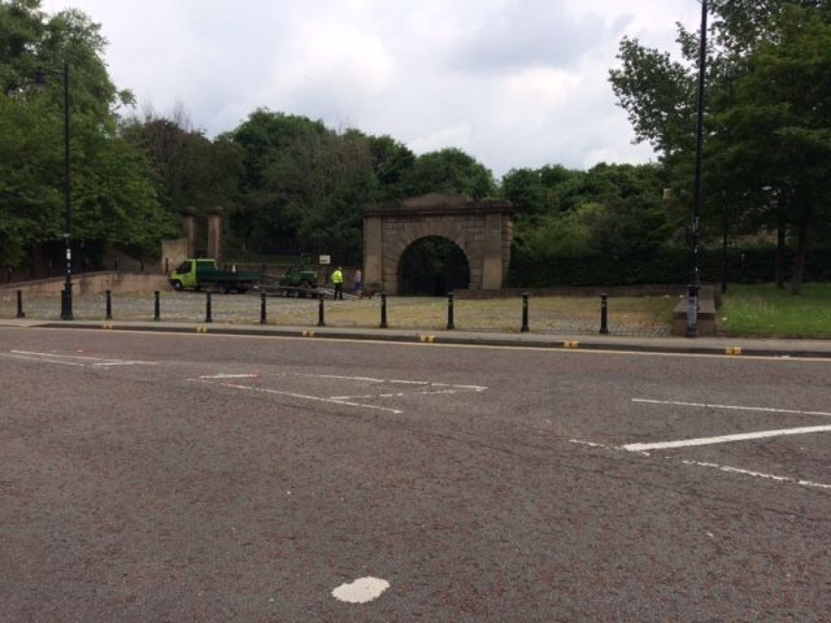
The principal entrance (listed grade II) lies on the west boundary to St James's Road at the south-west corner of the cemetery and is set back from the road beyond a C20 rectangular forecourt. The entrance is marked by a carriage entrance with C20 iron gates within a round rusticated stone archway, constructed in 1827 to a design by Foster. The archway is flanked by low stone walls with C20 railings. A C20 pedestrian gate set between panelled stone piers which lies 20m north-north-west of the principal entrance gives access to a grassed walk leading northwards forming the eastern boundary of St James's Mount (outside the area here registered). The piers are of similar design to those forming part of the boundary wall to the Oratory, which date from 1829. A two-storey stone lodge (listed grade II) set in its own garden is situated to the east of the principal entrance and was constructed in 1827 to a design by Foster.
A second pedestrian entrance, situated c 50m to the north of the cathedral and to the south of the Oratory, leads into the north-west corner of the cemetery. It is marked by C20 iron gates. The entrance to the grounds of the Oratory lies on the west boundary and is marked by C19 cast-iron gates, of similar design to adjoining railings, between panelled stone piers (listed grade II) of similar design to those adjacent to the principal entrance. Three further carriage entrances indicated on the 1891 OS map, at the north-east and south-east corners and on the east boundary, no longer (2001) remain.
Principal Building
The Oratory (listed grade I), the former mortuary chapel, is situated on high ground above a steep rocky eminence at the north-west corner of the cemetery. Designed by Foster, it dates from 1829 and is in the form of a miniature Greek Doric temple. The Bennison plan of 1835 indicates a carriageway, parallel to the north cemetery boundary, leading from the Oratory to the north-east corner of the cemetery to connect with ramped carriageways leading down to the former quarry floor. This route remains but is now (2001) overgrown.
Other land
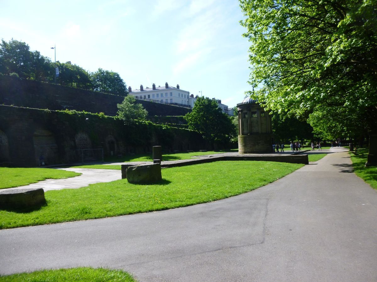
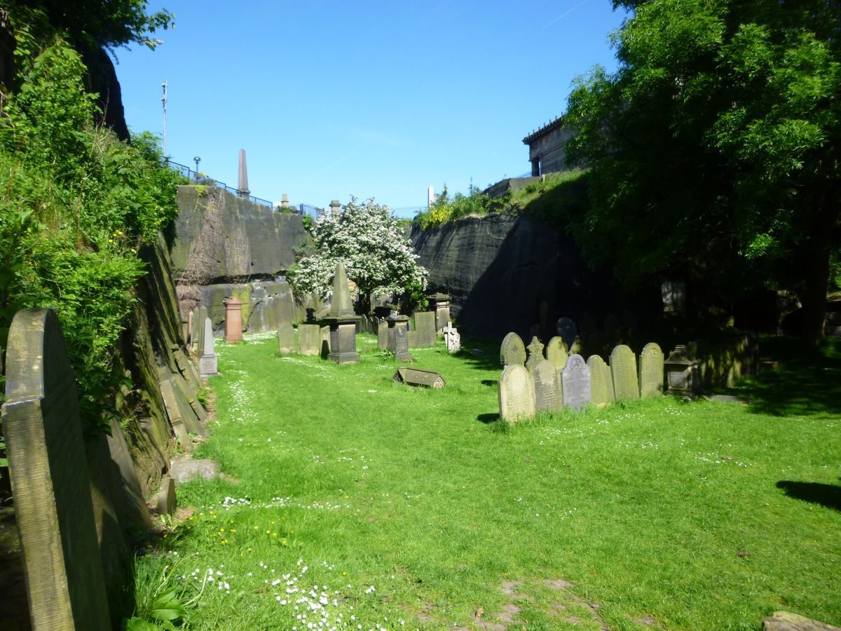
The cemetery comprises a lower burial area enclosed by steep wooded embankments to the south, west, and north, with sheer stone faces at the north-west and south-west corners and the mass of the Anglican cathedral set at the head of the western embankment. This embankment continues south of the cathedral to divide the lower cemetery area from St James's Mount to the south-west.
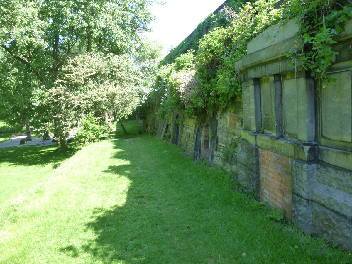
To the east the cemetery is enclosed by two ramped carriageways which commence 120m north-east and 320m north-north-east of the principal entrance, leading up from the lower level and aligned with the east boundary. Each carriageway is in two sections in a scissor arrangement with all sections intersecting at a central intermediate platform. The ramped carriageways terminate 140m north-east and 360m north-north-east of the principal entrance, where a level path runs parallel to, and level with, the east boundary. From the north and south ends of this boundary path there are views out over the river valley to the west. The two sections of each ramped carriageway are divided by a parallel level path. Both paths and ramped carriageways are lined to the east by catacombs cut out of the adjoining battered wall, which is in part rockwork and in part solid stone. The ramped carriageways and boundary path are bounded by low stone walls to the west, overlooking the burial area below. The whole is now largely overgrown with ivy and other vegetation.
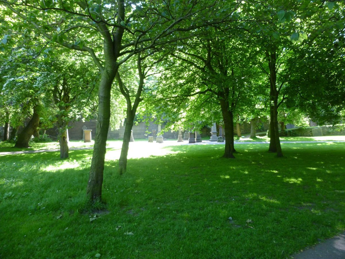
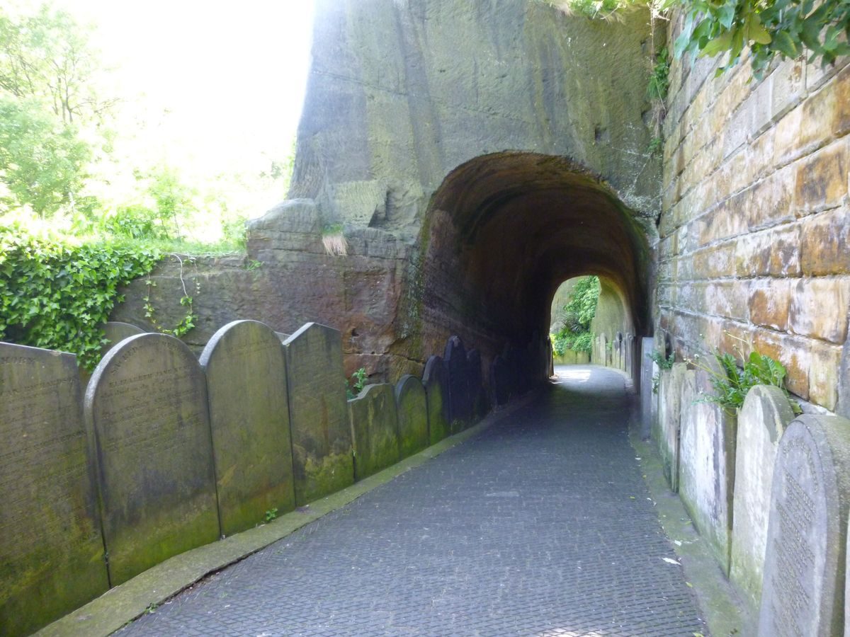
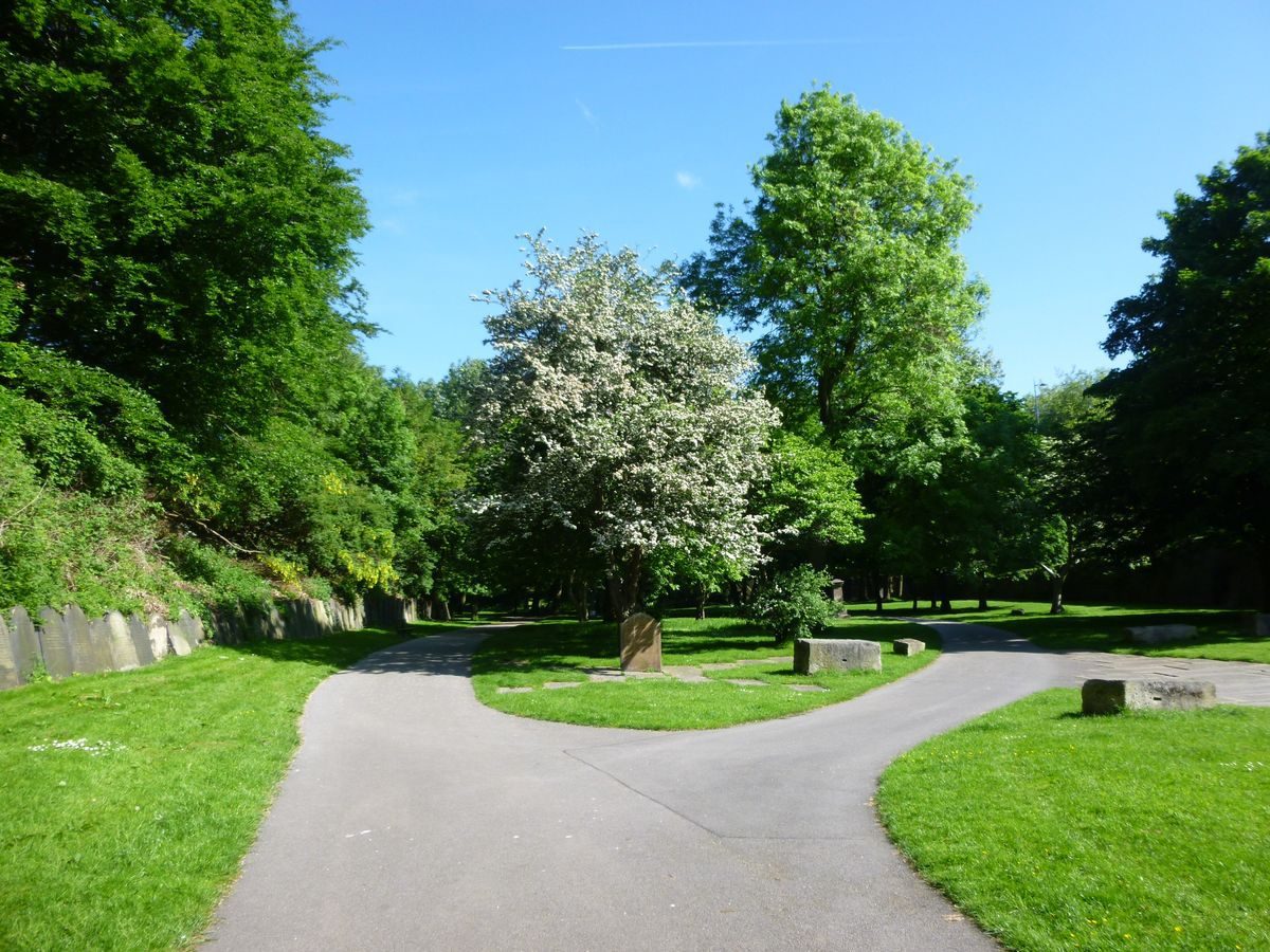
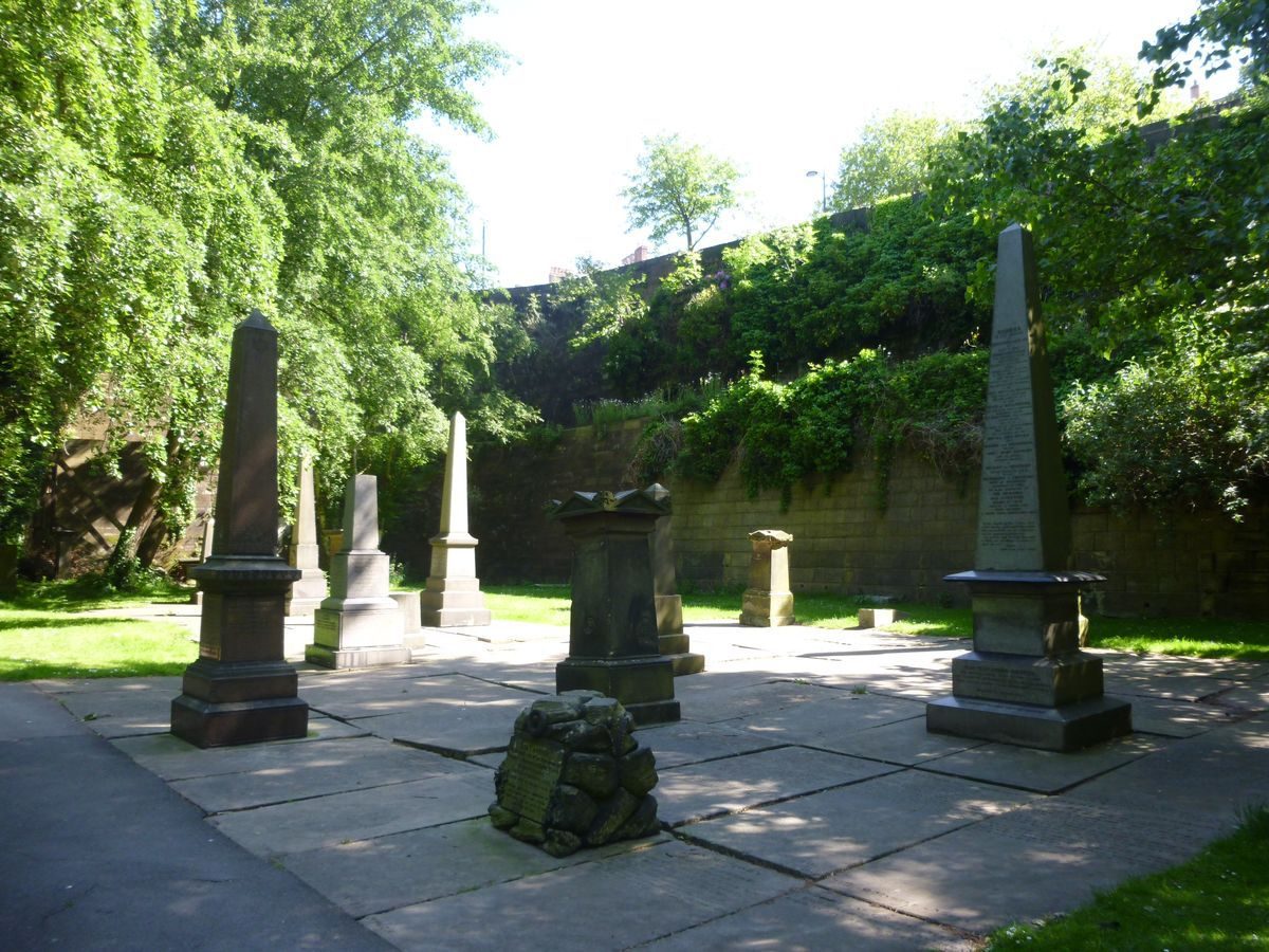
From the principal entrance an informal path leads down 70m east-north-east to the lower level of the cemetery where it divides, with one path leading north and the second north-east to the southern ramped carriageway before returning north to rejoin the first path. The southern area of the cemetery is generally planted with trees in grass below wooded slopes to the west, south, and east. A small group of vertical gravestones remains 50m east-north-east of the principal entrance, with others resited along the base of the western slope and occasional monuments sited in grassed areas.
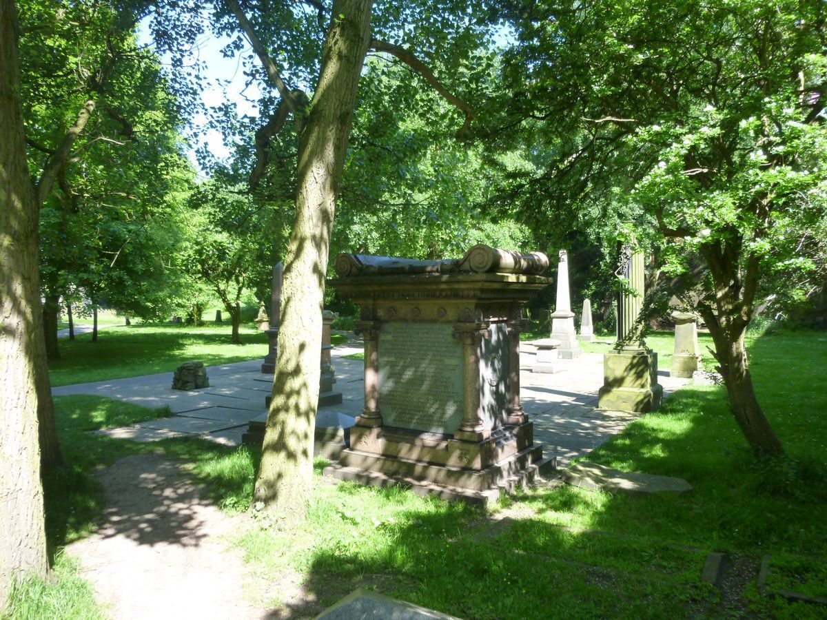
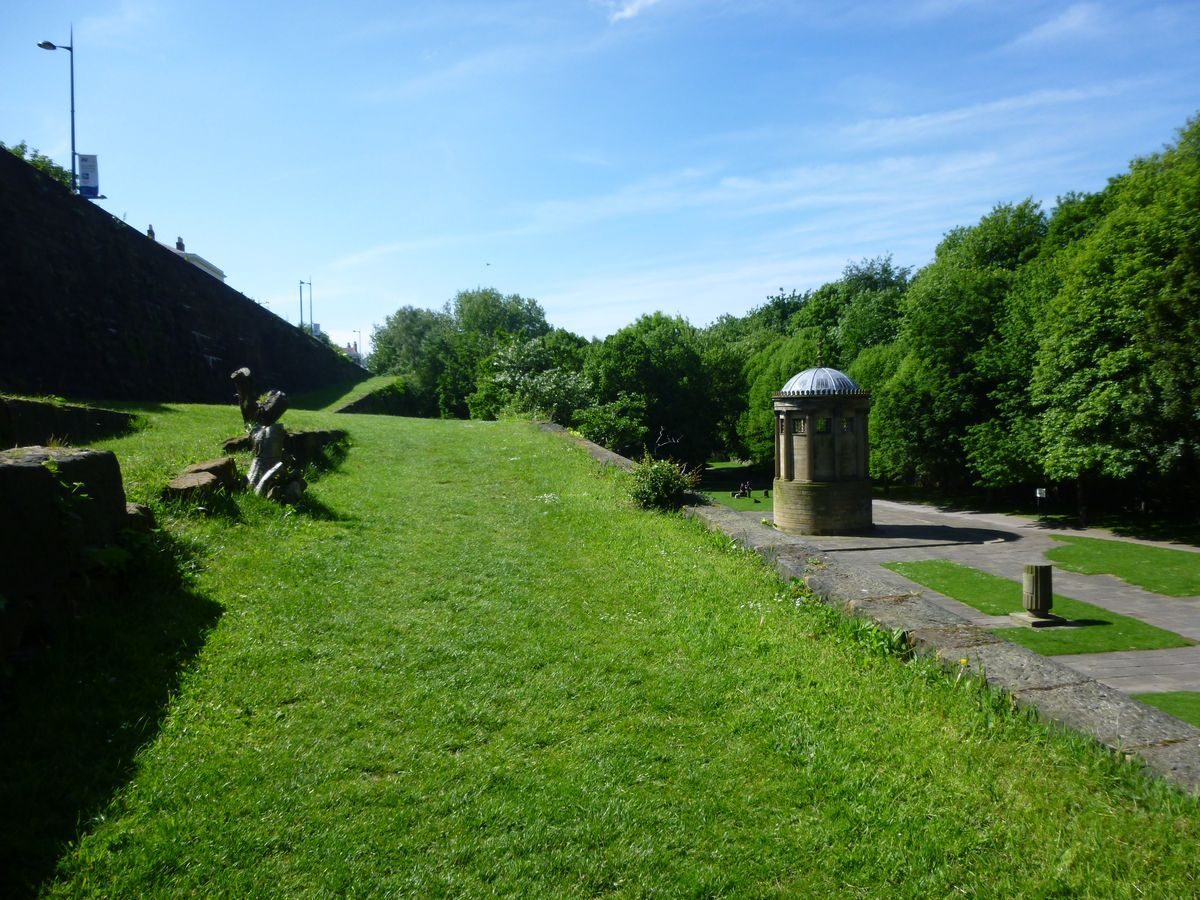
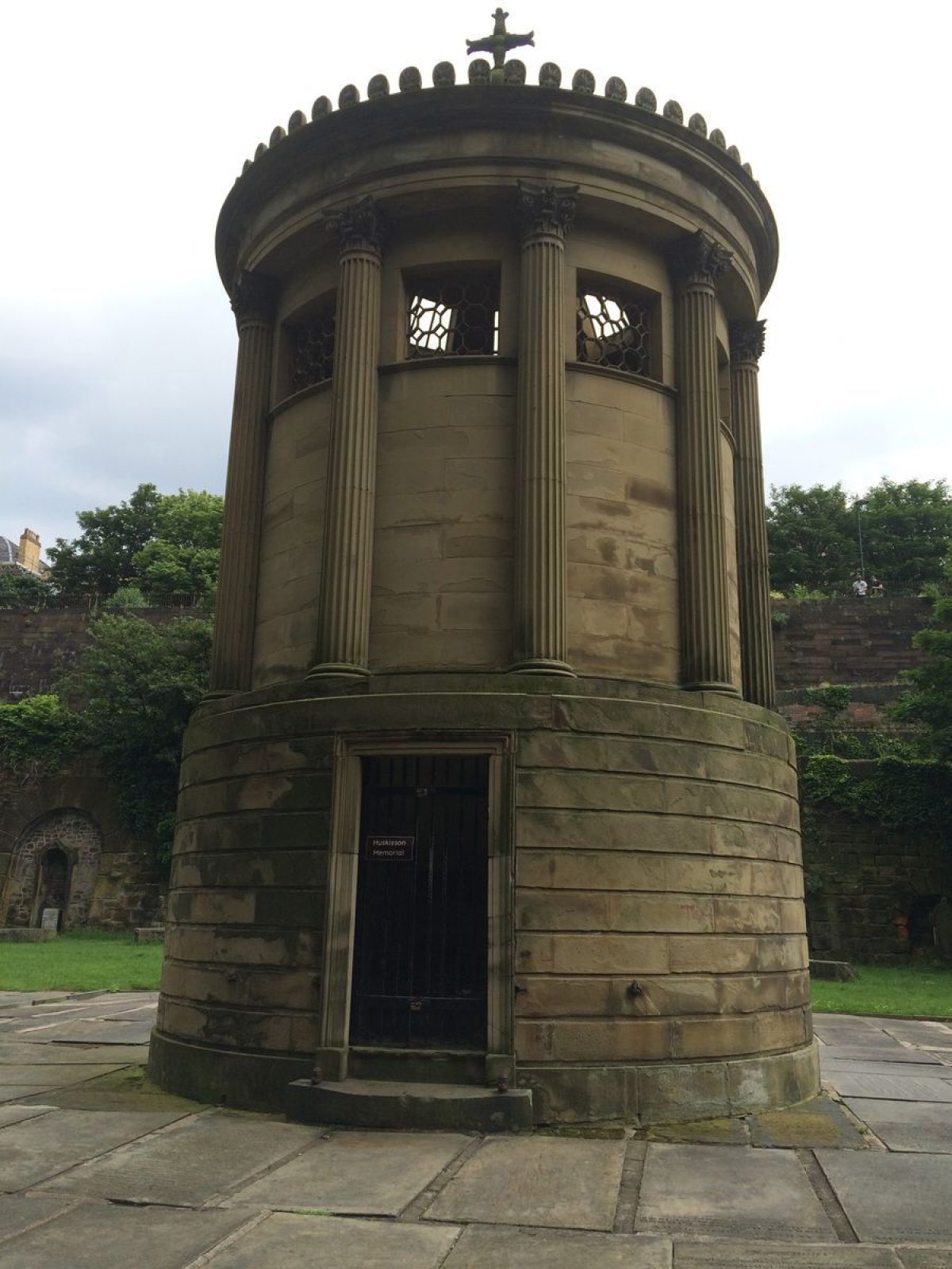
At the centre of the site, 190m north-north-east of the principal entrance, is sited the Huskisson Monument (listed grade II). Built in 1836 to a design by Foster, it is a tall circular stone structure in Greek Revival style and is an adaptation of the Choragic Monument of Lysicrates at Athens. It commemorates William Huskisson, MP for Liverpool, who was run down by a train at the opening of the Liverpool and Manchester railway in 1830. The central area has generally been cleared of monuments and was relandscaped in the 1960s with paving and low stone walling, the work commemorated by a low concrete monument. Vertical gravestones have been resited in a continuous line at the base of the western wooded slope. To the east, the base wall of the ramped carriageways is lined with arches with recessed stonework marking catacombs. One of the archways located 230m north-north-east of the principal entrance contains a chalybeate spring, with inscribed plaque over, which flows into a rectangular pool to the west of the archway. A chalybeate spring was first noted in the former quarry in 1773 and was reputed to have healing powers (Lloyd-Jones 1979).
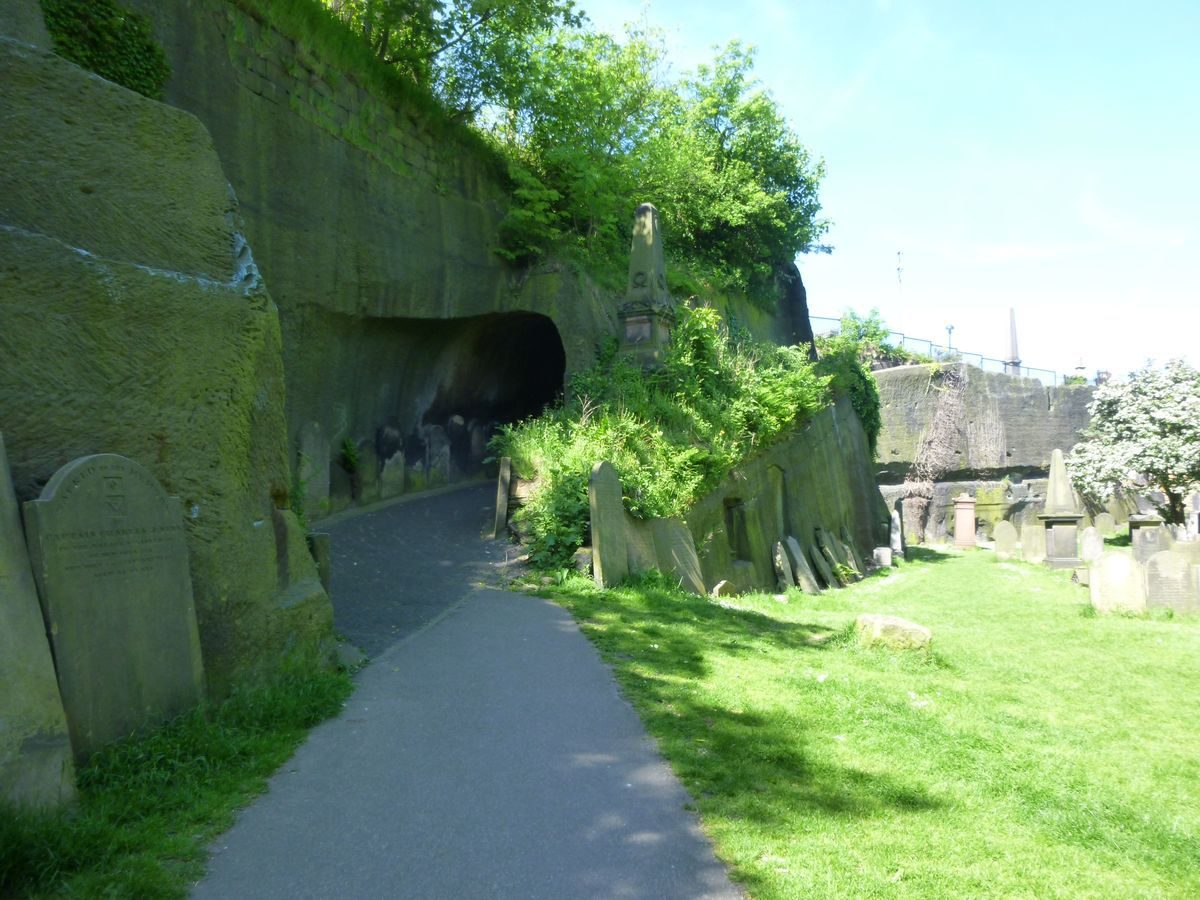
From the central area of the cemetery two paths lead north to a point 340m north of the principal entrance, from where a path leads west for 30m to the entrance to an arch (listed grade II) cut out of the natural rock of the cemetery wall. The arch dates from 1824 and forms part of Foster's design. The path slopes up through the arch and continues to the north pedestrian entrance. In the coursed stone wall below this path a round archway marks a former tunnel leading south from the lower level of the cemetery. A further arch marking a second tunnel leading north-west is located in the former quarry face to the south-west of the Oratory.
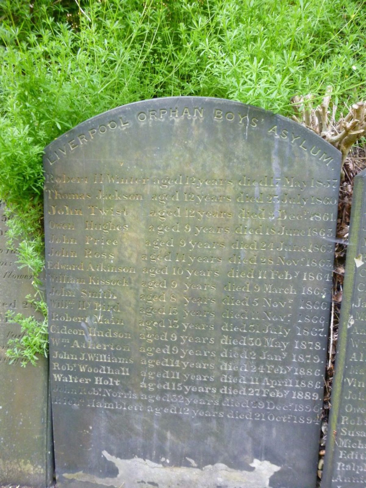
In the north-east corner of the cemetery a group of monuments remains standing, with gravestones laid flat between, and in the north-west an area remains with both gravestones and monuments marking burial plots.
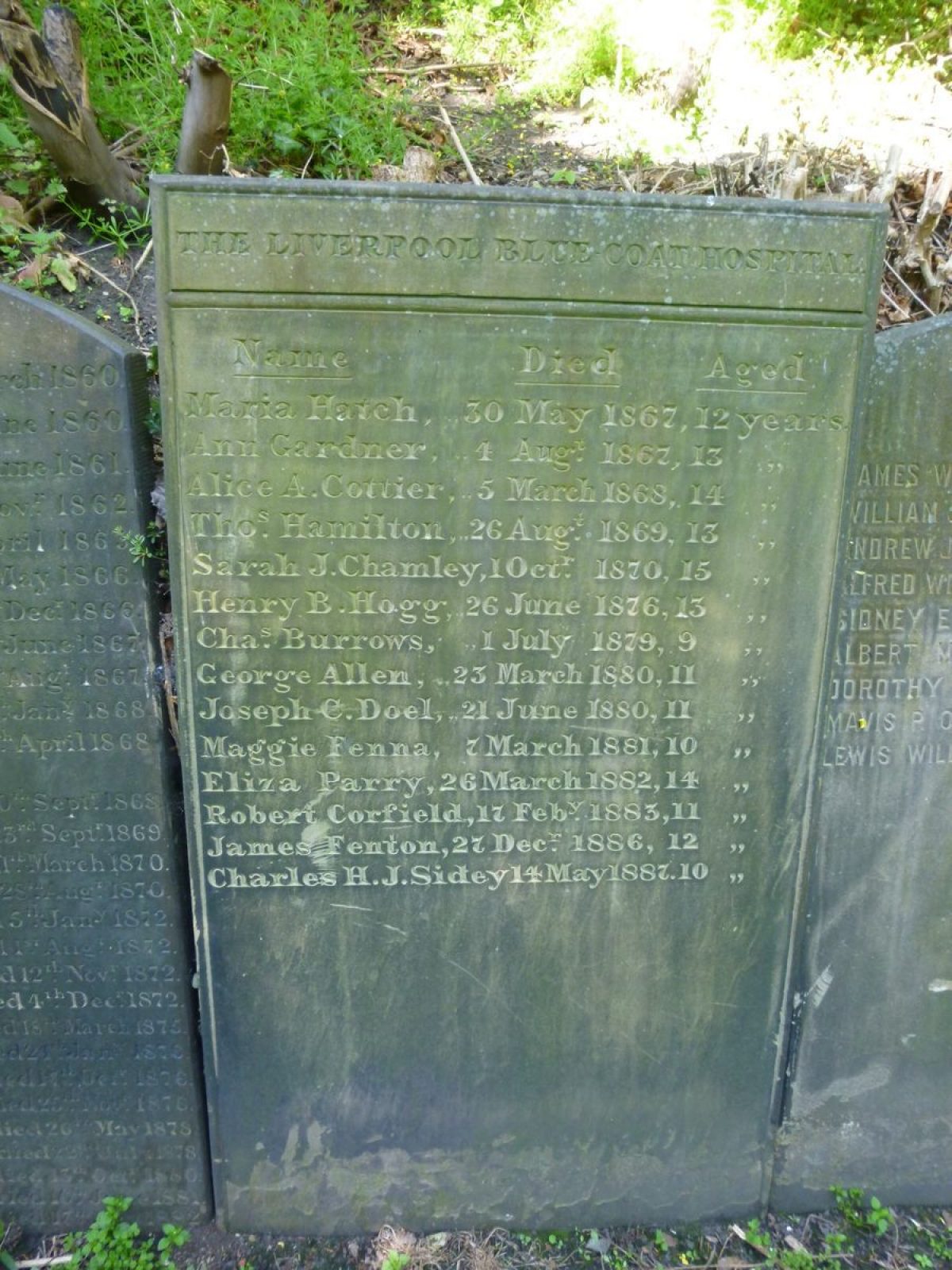
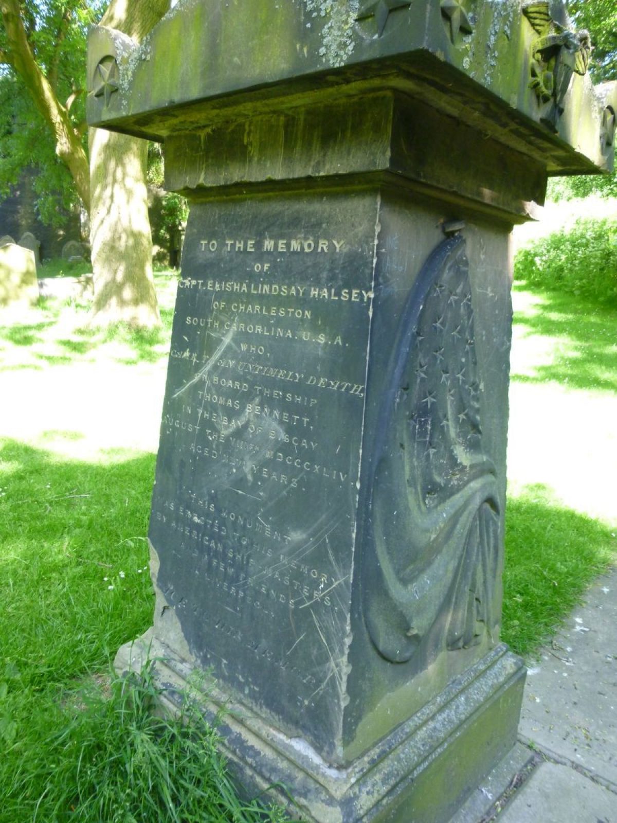
Amongst others, St James's Cemetery contains the graves of its architect, John Foster, Kitty Wilkinson (1786-1860) who originated the idea of the public wash house, and Sarah Biffin (1784-1850) who, although only 37" (c 1m) high and born without arms and legs, became a miniature portrait painter with royalty among her commissions.
Despite the 1960s landscaping of the central area of the site, St James's Cemetery retains the majority of its early C19 features and much of its 1829 layout.
Maps
- J Eyes, Plan of the Town and Township of Liverpool ... Corporation Estate, 1765 (Liverpool Record Office)
- C Eyes, A Plan of the Town and Township of Liverpool, 1785 (Liverpool Record Office)
- J Gore, A Plan of the Town of Liverpool, 1796 (Liverpool Record Office)
- R Horwood, Plan of the Town and Township of Liverpool, 1803 (Liverpool Record Office)
- W S Sherwood, A Plan of the Town and Township of Liverpool, 1821 (Liverpool Record Office)
- J Bennison, A Map of the Town and Port of Liverpool, 1835 (Liverpool Record Office)
- OS 6" to 1 mile: 1st edition published 1851; 1938 edition
- OS 1:500: 1st edition published 1891
Illustrations
C19 illustrations and early C20 photographs at local history site www.g0ifk.u-net.com.
Archival items
Notes on the history of Liverpool Parks, 1987 (Liverpool City Council)
Reasons for designation
St James's Cemetery is designated at Grade I for the following principal reasons:
- One of the earliest garden cemeteries (1827-29).
- The most impressive and innovative example of the earliest decade of cemetery design (1819-30) by a combination of a renowned local architect, John Foster and local landscaper, John Shepherd.
- It is the finest early example (1820s) of a garden cemetery, the first to take advantage of a quarry, using its steep sides to dramatic effect, including great ramps probably originally intended for catacombs.
- The first example of a cemetery set in a disused quarry, a type of site which became quite common in the 1830s-40s.
- The site and its heroic-scale layout survive complete.
- Local and national social interest is expressed in the artistic variety of the remaining monuments and burials, including the Huskisson monument which forms the focal point of the cemetery.
Description written: October 2001
Amended: October 2001
Edited: August 2002
Upgraded: November 2009
- Visitor Access, Directions & Contacts
Access contact details
This is a municipal site for general public use.
Owners
Liverpool City Council
Municipal Buildings, Dale St, Liverpool, L2 2DHOther Websites
- https://historicengland.org.uk/advice/heritage-at-risk/search-register/list-entry/24681
- https://liverpoolhistorysociety.org.uk/image_of_the_week/st-james-cemetery/
- https://www.liverpoolmuseums.org.uk/walker-art-gallery/oratory-st-jamess-cemetery
- https://www.findagrave.com/cemetery/2153947/st-james-garden-cemetery
- History
The following is from the Register of Parks and Gardens of Special Historic Interest. For the most up-to-date Register entry, please visit The National Heritage List for England (NHLE):
18th Century
In the C18 the site of the cemetery was a stone quarry, with the spoil heap, to the western side, known as Quarry Hill (Eyes, 1765). In 1767, at a time of high bread prices, the mayor, Thomas Johnson, provided employment in levelling the spoil heap to form a level terrace planted with shrubs as a pleasure ground and with an observation mound (Twist 2000). The reclaimed area was at first known as Mount Sion and from 1774 as St James's Mount, after the new St James's church nearby (Kennerley 1991), with a promenade, St James's Walk, along the western side (Gore, 1796).
19th Century
By 1825 the quarry was exhausted. A joint stock company was formed by Liverpool's Anglican community to convert the 10 acre (c 4ha) site into a cemetery as an alternative to the recently opened Nonconformist Low Hill Cemetery (now, 2001, destroyed). Liverpool Corporation contributed the land for the cemetery and £9000 for laying it out in exchange for shares in the company (Picton 1903). Work commenced in August 1827 and the cemetery was consecrated on 13 January 1829, with the first burial taking place in July of that year. The total cost of the cemetery was £21,000 (Curl 1980). By 1830 the cemetery company was paying a dividend of 8% (Brooks 1994). Entrances, carriage ramps, and buildings were designed by Liverpool architect John Foster (1787-1846), who had also been the architect for Low Hill. The landscaping was by John Shepherd (1764-1836), who was curator of the Botanic Garden in Liverpool and responsible for the design of the resited Wavertree Botanic Garden (qv), opened in 1836.
The design made dramatic use of the quarry site with a lodge to the south and the Oratory mortuary chapel to the north. Built on higher ground above the quarry floor at the head of sandstone cliffs (Bennison, 1835), these occupied the sites of former windmills (Eyes, 1785). To the east of the quarry floor a series of ramps led up the quarry face, with vaults set into the rocky bank where they required no drainage and could be entered without descending more than a few steps (Loudon 1843). As a whole the design emphasised enclosure which was to become a major element in English cemetery design in the first half of the C19 (Brooks 1994). St James's Cemetery has also been described as the most romantic in England (Pevsner 1969).
20th Century
In 1901 the larger part of St James's Mount and Walk, to the west of the cemetery, was chosen as the site for a new Anglican cathedral on which work commenced in 1904.
21st Century
In 2001 only the southern section of St James's Mount and Walk remains, the northern section being occupied by the cathedral.
The last interment in St James's Cemetery took place on 10 June 1936 when the burial ground was declared full. In the 1960s many gravestones were resited, the central area of the cemetery relandscaped, and the site renamed Cathedral Grounds. The Oratory was restored in 1981 for use as a sculpture gallery. The lodge is now (2001) in private ownership.
St James's Cemetery remains in use as a public open space and in the ownership of Liverpool City Council.
- Associated People
- Features & Designations
Designations
Conservation Area
The National Heritage List for England: Register of Parks and Gardens
- Reference: GD5064
- Grade: I
Site of Special Scientific Interest
Features
- Boundary Wall
- Description: Most of the boundaries are marked by low stone walls topped with 20th-century railings.
- Boundary Wall
- Description: Boundaries adjoining the Oratory are marked by a low stone walls topped with cast-iron railings set between panelled stone piers.
- Earliest Date:
- Latest Date:
- Walk
- Description: St. James's walk.
- Earliest Date:
- Latest Date:
- Entrance
- Description: The principal entrance lies on the west boundary to St James's Road at the south-west corner of the cemetery. There is a carriage entrance with 20th-century iron gates within a round rusticated stone archway, constructed in 1827 to a design by Foster. The archway is flanked by low stone walls with 20th-century railings
- Earliest Date:
- Latest Date:
- Gate Lodge
- Description: A two-storey stone lodge set in its own garden is situated to the east of the principal entrance and was constructed in 1827 to a design by Foster.
- Earliest Date:
- Latest Date:
- Entrance
- Description: There are two pedestrian entrances.
- Chapel (featured building)
- Description: The Oratory, the former mortuary chapel, is situated on high ground above a steep rocky eminence at the north-west corner of the cemetery. It is in the form of a miniature Greek Doric temple.
- Earliest Date:
- Latest Date:
- Gate Piers
- Description: Panelled stone piers of similar design to those adjacent to the principal entrance.
- Embankment
- Description: Steep wooded embankments.
- Designed Route
- Description: Two ramped carriageways, each one in two sections in a scissor arrangement with all sections intersecting at a central intermediate platform.
- Cenotaph
- Description: The Huskisson Monument is a tall circular stone structure in Greek Revival style and is an adaptation of the Choragic Monument of Lysicrates at Athens.
- Earliest Date:
- Latest Date:
- Religious, Ritual And Funerary Features
- Description: The base wall of the ramped carriageways is lined with arches with recessed stonework marking catacombs.
- Spring
- Description: A chalybeate spring, with inscribed plaque over.
- Arch
- Description: An arch cut out of the natural rock of the cemetery wall.
- Earliest Date:
- Latest Date:
- Tomb
- Description: Amongst others, St James's Cemetery contains the graves of its architect, John Foster, Kitty Wilkinson and Sarah Biffin.
- Key Information
Type
Garden
Purpose
Recreational/sport
Principal Building
Religious Ritual And Funerary
Survival
Part: standing remains
Hectares
4
Open to the public
Yes
- References
References
- Loudon, John Claudius {On the laying out, planting, and managing of cemeteries and on the improvement of Churchyards} (London, 1843) 26 On the laying out, planting, and managing of cemeteries and on the improvement of Churchyards
- {English Heritage Register of Parks and Gardens of Special Historic Interest}, (Swindon: English Heritage, 2008) [on CD-ROM] Historic England Register of Parks and Gardens of Special Historic Interest
- Brooks, C. {Mortal Remains} (Exeter: Wheaton, 1989), pp. 8-10, 16, 19, 24, 50, 89-90, 141 Mortal Remains: the history and present state of the Victorian and Edwardian cemetery
- Conway, H., {People?s Parks: The Design and Development of Victorian Parks} (Cambridge: Cambridge University Press, 1991), p. 27 People's Parks: The Design and Development of Victorian Parks in Britain
- Pevsner, Nikolaus and others {The Buildings of England: Lancashire: Liverpool and the South-West} (London: Yale University Press, 2006) The Buildings of England: Lancashire: Liverpool and the South-West
- Picton, J., (1903), p 401 Memorials of Liverpool
- Lloyd-Jones, T., (1979), pp 54-55 Know Your Liverpool: Walks in the City Centre
- Curl, J. S., (1980), pp 208-09 A Celebration of Death
- Kennerley, P., (1991), pp 16-17, 20 The Building of Liverpool Cathedral
- Brooks, C., (English Heritage theme study 1994), p 67 English Historic Cemeteries
- Twist, C., (2000), pp 2-5 A History of the Liverpool Parks
- no 3 (Summer 1975), p 19 Garden History 3