Introduction
Harleyford has the remains of a mid-18th-century landscape park of about 100 hectares (85 hectares are registered), attributed to Lancelot 'Capability' Brown. The site lies on the north bank of the River Thames, surrounded by woodland, agricultural land and a golf course.
Terrain
Floodplain and steep valley.www.historicengland.org.uk/listing/the-list
A mid to late C18 landscape park and pleasure ground, possibly laid out by Lancelot Brown, surrounding a 1755 Thames-side villa.
DESCRIPTION
LOCATION, AREA, BOUNDARIES, LANDFORM, SETTING
Harleyford lies in the Chiltern Hills, 2.5km south-west of Marlow. The 85ha site is bounded to the north by the A4155 Marlow to Henley road, to the west by the Wittington estate, to the south by the River Thames and to the east by agricultural land. The site is divided into three distinct topographical areas: the south-eastern corner and river frontage along the whole site, containing the house, east park and kitchen gardens, situated on flat flood plain; the valley side, bisecting the site south-west to north-east, which rises for 30m very steeply northwards; and the northern plateau, which slopes up from the valley edge for 0.5km to the Henley Road. The setting to the north is largely agricultural and woodland, with Marlow to the north-east beyond a golf course immediately east of the site; immediately to the south, the river and its islands are dominant from the low-lying land; from the valley side and top the wider setting is prominent, encompassing the flat Thames Valley to the south and south-east, as far as the hills rising up to the Pinkneys Green plateau.
ENTRANCES AND APPROACHES
The 1996 main entrance, at the north corner of the site, off the Henley Road, passes a barrier and security building to join the course of the north drive 100m south of the road. The brick and flint North Lodge (listed grade II), dated 1866, together with two small, flanking brick bothies in matching style, lies at the head of the north drive, next to the Henley Road, 75m west of the new entrance and 900m north of the house. The north drive runs from the Henley Road through 200m of woodland before emerging into the north park, where it is flanked by an avenue of mature, mixed species, predominantly lime. The drive curves south, dropping down past the brick Middle Lodge at the south edge of the park, to arrive at the irregular triangular turning circle by the north front of the house. On the north side of the circle opposite the house is the white-painted, two-storey Dower House, and several other C19 buildings set into a disused quarry at the bottom of the valley side.
The east drive enters 900m north-east of the house, off Harleyford Lane, past East Lodge, in similar style to Middle Lodge, and through two stout stone gate piers. It then crosses the low-lying east park, through an avenue of limes, changing direction several times. As it reaches the kitchen garden from the north, the east drive turns sharply west, at which point is situated a copy of a statue of Sir Robert Clayton (1867, listed grade II), erected by Sir William Clayton. The drive and flanking avenue then take a straight course west towards the east front of the house for nearly 0.5km, curving north where the avenue ends, c 150m from the house, to join the north drive and arrive at the north front. A further lodge at the north-west corner of the site, in the same style as the C19 East and Middle Lodges, indicates the start of a west drive (OS 2nd edition map published 1913), and a path through The Brambles woodland as far as the north drive, now both overgrown. The site is also approached by water, possessing a landing stage south of the house and slipway further east in the east park.
PRINCIPAL BUILDING
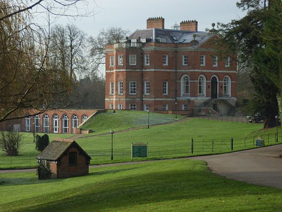
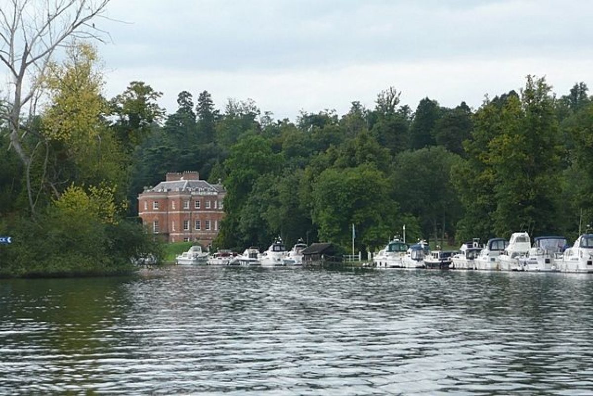
Harleyford Manor (1750s, listed grade I) lies on the southern edge of the site, close to the river, a red-brick villa designed by Sir Robert Taylor and completed by 1755. It was Taylor's first country house, and of a pioneering compact and adaptable design. The main, first-floor entrance on the north front has a double return flight of stone steps with wrought-iron railings leading up from the turning circle. The east and west fronts face lawns, with oblique views of the river, and the south front looks directly onto the river and the islands beyond, with a simple curved balcony with wrought-iron railings at the first-floor level of the projecting curved bay. The house was restored in the 1980s.
GARDENS AND PLEASURE GROUNDS
There are no formal gardens around the house, which sits on a C19 rectangular platform laid to lawn, raised above the surrounding lawn, with several small topiary yew and box plants, all surrounded by an iron fence. East of the house a late C20 basement extension emerges east of the house in the eastern terrace slope, fronted by an arcaded screen wall facing east. Informal lawns flanking the house platform extend 300m west at the bottom of the steep valley side, and 50-100m east, merging into the park, both lawns following the line of the river edge.
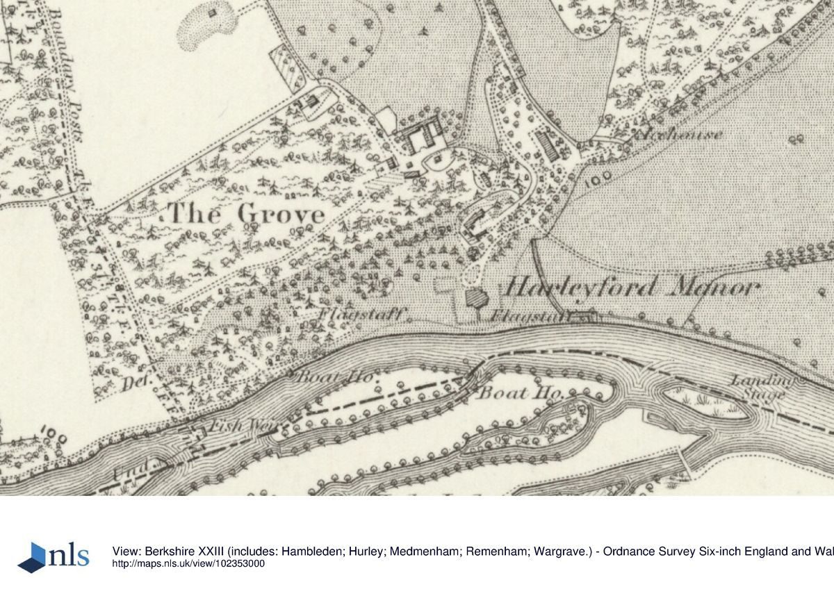
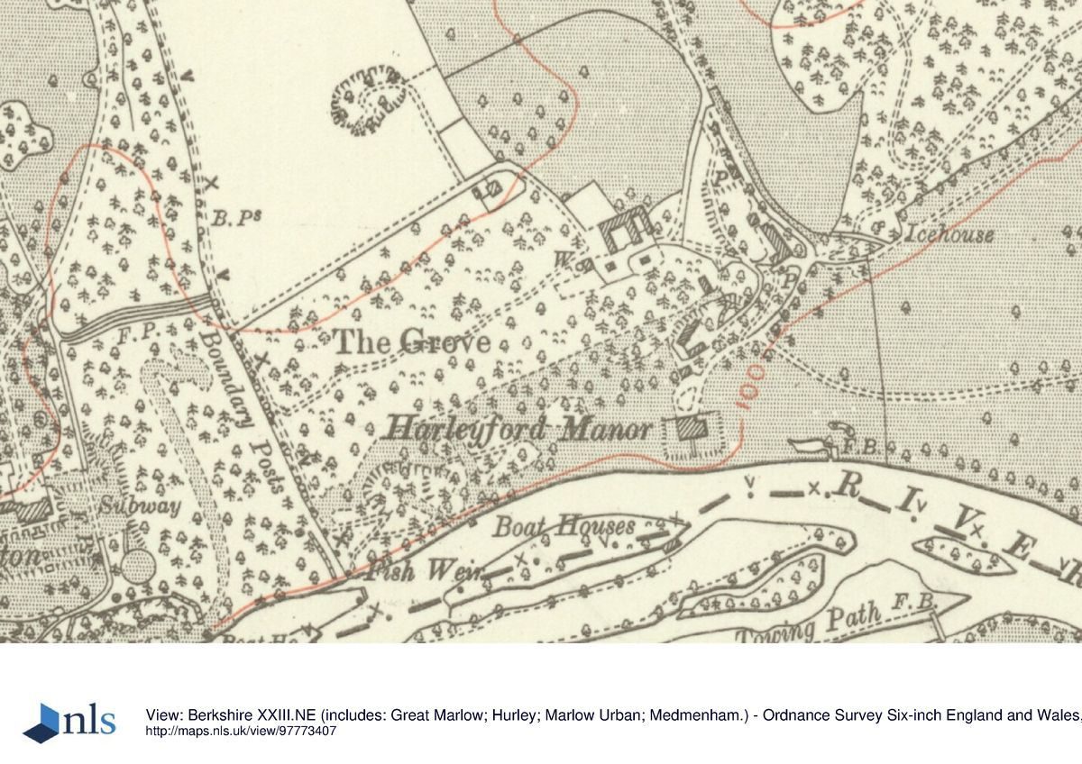
The Grove, which lies north-west of the house, is terraced (probably C18 origin) and may have been an C18 pleasure ground. At the east end of The Grove, north of and overlooking the house, lies the late C18 Dairy (listed grade II), consisting of a rectangular, single-storey, flint main block with Gothic-arched windows and doors, and an oval pebble-dashed pavilion at the south end. This may have been a picturesque eyecatcher from the house and lawns by the river, sitting prominently high above them at the top edge of the valley side and enjoying fine views back down to the south. At the south-west corner of The Grove, sited against the walls of an old quarry, lies the semicircular Shell Grotto, a domed and rendered feature with a seat and flint arch, recently renovated. The Grotto faces south down a short path to the riverside lawn, from where it is approached from the house via a raised mound parallel to the river bank. The river is just visible from the Grotto. The steep slope between the Dairy and Grotto may also have been part of The Grove, with C19 specimen trees and evergreen shrubs including box, holly, Portugese laurel and yew planted along it, and views through the trees down the slope to the river and beyond. A stone statue of Sir Robert Clayton (1714, listed grade II), lies in The Grove, brought from Christ's Hospital, London c 1900. A development of log cabins has been sited amongst the trees in the southern half of The Grove, with associated circular drive system, and a car park has been placed in the north-east quarter, close to the golf clubhouse.
PARK
The park falls into two main divisions. The north park, now part of the golf course, is sited on the north plateau with sparse single trees. Surrounded by woodland, the north drive runs north/south through it. At the southern end a brick barn complex has been converted into a golf clubhouse. The east park, recently restored to pasture as parkland, having been a caravan park, is sited on flood meadows, bounded to the west and north by Home Copse woodland and to the south by the river, with views of the river and the bank beyond it. It has several clumps of trees, a line of trees running along the riverside and the east drive running through it.
KITCHEN GARDEN
The walled kitchen garden, built of red brick, lies 500m east of the house, located at the eastern corner of the east park. The area is divided into three rectangles, separated by brick walls, each with a semicircular archway. The west compartment is an estate yard; the two further east are used as a caravan park. A low, C19, ornamented brick bothy runs along the western compartment outside the north wall, connected to the C19 brick gardener's cottage with its turret, which is in similar, but grander, style to the East and Middle Lodges. A second, less elaborate, gardener's cottage lies on the west wall of this compartment. In the 1900s the kitchen garden was extensively planted as an ornamental flower garden by Lady William Clayton (CL 1910).
OTHER LAND
A large area consists of woodland. The Brambles is an area of mixed woodland and rhododendron to the north, forming a buffer zone between the north park and the Henley Road. It originally (OS 1913) had several paths running through it, which are now overgrown. Home Copse, on the east boundary of the site, is a large block of mixed woodland, with a network of paths throughout, and at its north-eastern edge a mid to late C18 domed temple (listed grade II), the principal built ornamental landscape feature on the site. The temple may be the Temple of Friendship of 1775, built at the expense of the Bishop of Rochester for the second Sir William Clayton (Pevsner 1994). It is octagonal, ashlar-faced over brick, with one storey and a basement, and three windows facing north across farmland (now a golf course), east towards Marlow, and south across the Thames valley. The entrance, on the west side, is reached by steps up to the main floor. It has recently been restored and the scrub which surrounded it has been removed. The temple now lies prominently positioned, backed by woodland to the west and with a curved moat or ditch to the north and east. A brick icehouse (mid to late C18, listed grade II), recently restored, lies close to the south-west corner of Home Copse, set into the valley side at the bottom of the slope. A development of log cabins is being erected (1997) along the southern edge of Home Copse, and a late C20 bungalow has been erected at its south-west corner.
The islands in the river may also form part of the designed landscape, and it is possible that Lancelot Brown may have worked on the formation or shaping of them. The small island closest to the house is mown lawn with many specimen trees. The larger island behind this, to the south, has a more natural character and is rather overgrown. Motor cruisers are moored all around the smaller, northern island and along the river bank.
REFERENCES
The Gardener's Magazine, (30 January 1904), pp 87-90
Country Life, 27 (4 June 1910), pp 810-19; 142 (27 June 1967), pp 17-18
D Stroud, Capability Brown (1975), p 228
J Harris, The Artist and the Country House (1979), p 281
N Pevsner and E Williamson, The Buildings of England: Buckinghamshire (1994), pp 372-3
arleyford Estate Landscape Restoration and Management Plan (Bell Fisher Landscape Architects 1994)
Maps
John Rocque, Map of Berkshire, 1761
Diversion of footpath on Harleyford estate, 1806 (Buckinghamshire Record Office)
Tithe map for Great Marlow parish, 1843 (Buckinghamshire Record Office)
Inclosure map for Great Marlow parish, 1855 (Buckinghamshire Record Office)
OS 6" to 1 mile:
2nd edition revised 1913
3rd edition published 1926
OS 25" to 1 mile: 1st edition published 1876
Archival items
Harleyford Deeds (D/CE) of 1717 (M270) and 1728 at Buckinghamshire Record Office.
Description written: 1997; Amended: April 1999
Register Inspector: SR
Edited: June 1999
- Visitor Access, Directions & Contacts
Telephone
44 (0)1628 471361Website
https://www.harleyford.co.ukAccess contact details
It may be possible to visit by appointment. Please see: http://www.harleyford.co.uk or telephone 01 628 471361
Directions
On the south side of the A4155 Marlow to Henley road.
Owners
Harleyford Estate Ltd
- History
The following is from the Register of Parks and Gardens of Special Historic Interest. For the most up-to-date Register entry, please visit the The National Heritage List for England (NHLE):
www.historicengland.org.uk/listing/the-list
HISTORIC DEVELOPMENT
Harleyford Manor House was the seat of the Manor of Great Marlow and Harleyford from at least the C16. Sir William Clayton Bt, of Marden, Surrey, bought the estate in 1728, continuing to use Marden, and keeping Harleyford as his summer residence. The house was surrounded by gardens, orchards, groves and walks, and also 'the Greens, Oranges, Bayes, Yews, Lawrell and all other Trees Shrubs Plants and Flowers' (Harleyford deeds, 1717 & 1728). John Rocque's 1761 Map of Berkshire shows a formal garden arrangement east and west of the old house. Sir William died in 1744, succeeded by his younger son, also William, who used Harleyford as his main residence and, finding the old house inconvenient, built a new house, a villa designed by Sir Robert Taylor and completed by 1755. During the remainder of the C18 the landscape was laid out, possibly by Lancelot Brown (1716-83), although there seems to be no documentary record of this. The open situation of the house, however, overlooking the river, the winding approach drive, and variation between woodland and open parkland might well be attributed to Brown. The major elements of the designed landscape are shown on a map of 1806 (BRO). The Claytons continued adding plants during the C19, creating the formal setting immediately around the house, and flower gardens in the walled gardens in the early C20, eventually selling the estate in 1950. In the late C20 various features have been added, including log cabins in the woods, a static caravan park in and around the walled garden and a golf course in the northern parkland; the house has become offices. Parts of the landscape were restored in the 1990s.
- Associated People
- Features & Designations
Designations
The National Heritage List for England: Register of Parks and Gardens
- Reference: GD1528
- Grade: II
Features
- Lawn
- Villa (featured building)
- Earliest Date:
- Latest Date:
- River
- Description: The estate is situated on the northern bank of the River Thames.
- Drive
- Description: Winding approach drive.
- Key Information
Type
Park
Purpose
Ornamental
Principal Building
Commercial
Survival
Extant
Hectares
100
Open to the public
Yes
Civil Parish
Great Marlow
- References
References
- {English Heritage Register of Parks and Gardens of Special Historic Interest} (Swindon: English Heritage 2008) [on CD-ROM] Historic England Register of Parks and Gardens of Special Historic Interest
- Stroud, D {Capability Brown} (1975) p 278 Capability Brown
- Pevsner, N and Williamson, E {The Buildings of England: Buckinghamshire} (1994) pp 372-373 The Buildings of England: Buckinghamshire