Introduction
Chilham Castle was a medieval deer park of 130 hectares extensively landscaped in the 18th and 19th centuries to include formal and ornamental gardens around the castle.
Terrain
The site lies on the western slopes of the valley of the Great Stour river which rise to the crest of a ridge of the North Downs along the south-west side of the park.The most dramatic changes have been due to the October 1987 storm. The worst damage has affected the great lime avenue leading from the entrance gates in the square to the east entrance of the house. This had been totally destroyed, and was replanted in the spring of 1988.
Also damaged were the limes near the Castle gates, two great atlas cedars, a fine tulip tree and the catalpas and magnolias below the terraces. Many ornamental trees and conifers in the 1930s planting near the lake were also damaged.
The ancient holm oak (Quercus ilex) on the front lawn largely survived, due it is thought to extensive tree surgery a few years ago. The old avenue of limes and sweet chestnuts of possible early 17th-century date was seriously damaged. By August 1988, a great percentage of fallen trees around the lake and park area still needed clearance.
The following is from the Register of Parks and Gardens of Special Historic Interest. For the most up-to-date Register entry, please visit the The National Heritage List for England (NHLE):
www.historicengland.org.uk/listing/the-list
Formal and ornamental gardens of C17 origin, altered in the C18 and restored and developed in the C19 and C20, which are set in a park of medieval origin with surviving C17 and C18 landscape features.
DESCRIPTION
LOCATION, AREA, BOUNDARIES, LANDFORM, SETTING
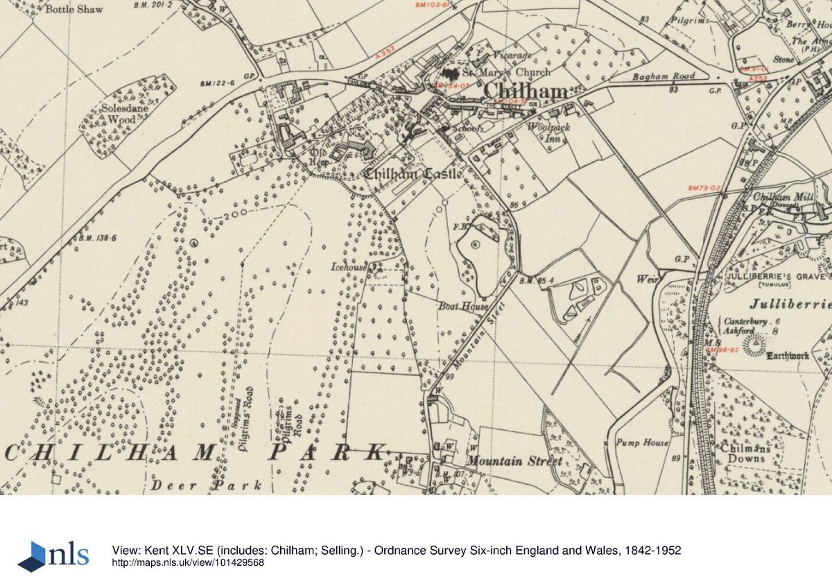
Chilham Castle lies on the south side of the A20, 8km south-west of Canterbury and immediately to the south-west of Chilham village. The registered site, comprising c 10ha of formal and ornamental gardens and a park of c 130ha, lie on the western slopes of the valley of the Great Stour river which rise to the crest of a ridge of the North Downs along the south-west side of the park. The site is bounded on the north-west side by trees fringing the A20, with farmland on rising ground beyond. To the north and north-east, the site is enclosed from the village by a largely C18 brick estate wall (listed grade II), with two houses built into it (Well Cottage 40m west of the lodges and Castle Cottage 45m south-east, both listed grade II). On the east side, a narrow lane, Mountain Street skirts the boundary, marked as far as the north edge of the hamlet of Mountain Street by a further length of estate wall, pierced by a clairvoie. To the south-west, the park merges into wooded farmland and to the south is separated from Godmersham Park (qv) only by a narrow strip of farmland.
ENTRANCES AND APPROACHES
The main formal approach to the Castle is on the north-east front, from the square in the centre of Chilham village. The entrance is through oak gates (restored 1997), flanked by a pair of identical lodges (listed grade II), which are set in the screen wall. The ensemble was designed c 1922 by Sir Herbert Baker (1862-1946) and replaced the gothic lodges and gates attributed to Lancelot Brown (Stroud 1975) and demolished in 1862 (Notes by A Bolton accompanying Wildman's watercolour sketches). An axial gravelled path, flanked by lawns and lined by a double avenue of limes, replanted in the mid 1990s to replace the original avenue of 1817 (ibid) which was destroyed in the storm of 1987, leads to a broad gravelled forecourt enclosed by a low terrace wall embellished with urns brought from Necton in Norfolk by Somerset de Chair. A vehicle route runs from the gates to the forecourt around the north-west side of the lawns, linking up on the west side of the Castle with a secondary, service drive (shown on Mudge's map of 1801) which enters the site from the A20 and passes the stable block.
PRINCIPAL BUILDINGS
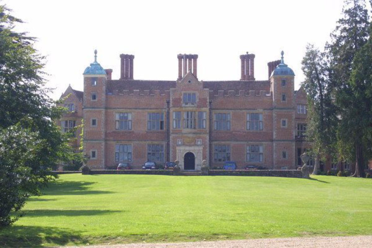
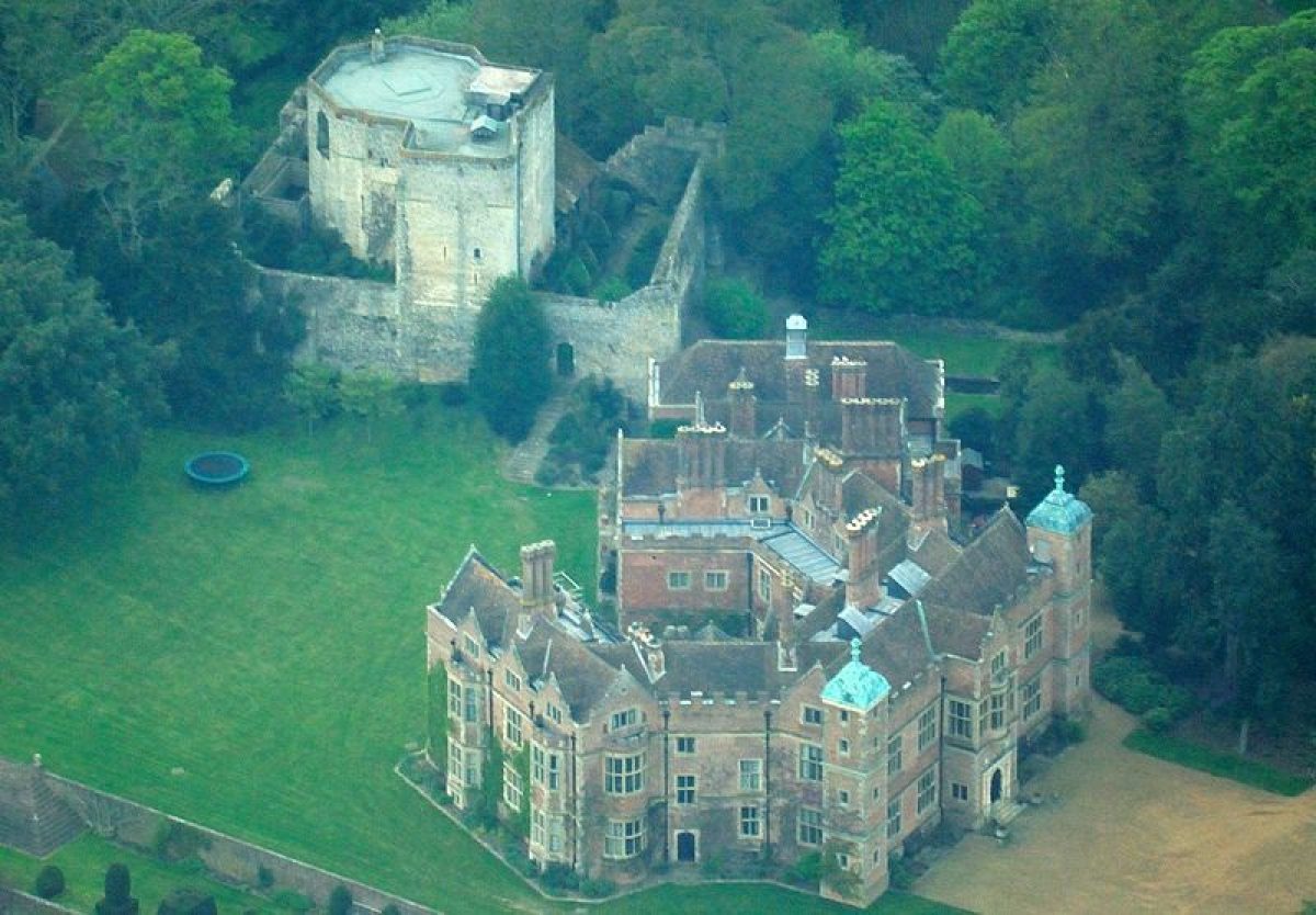
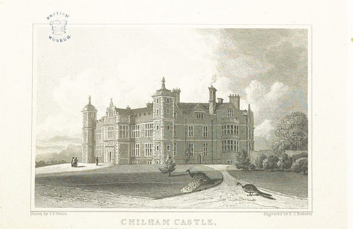
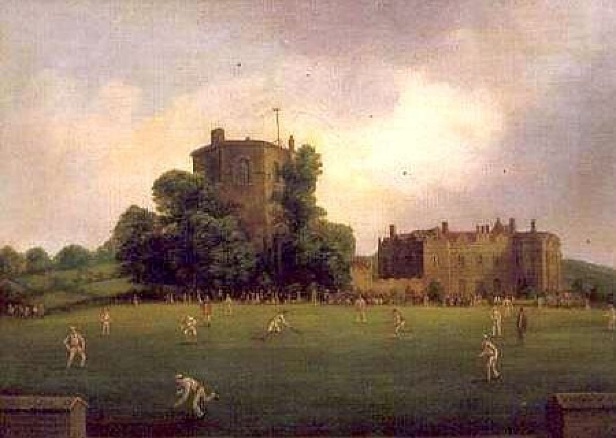
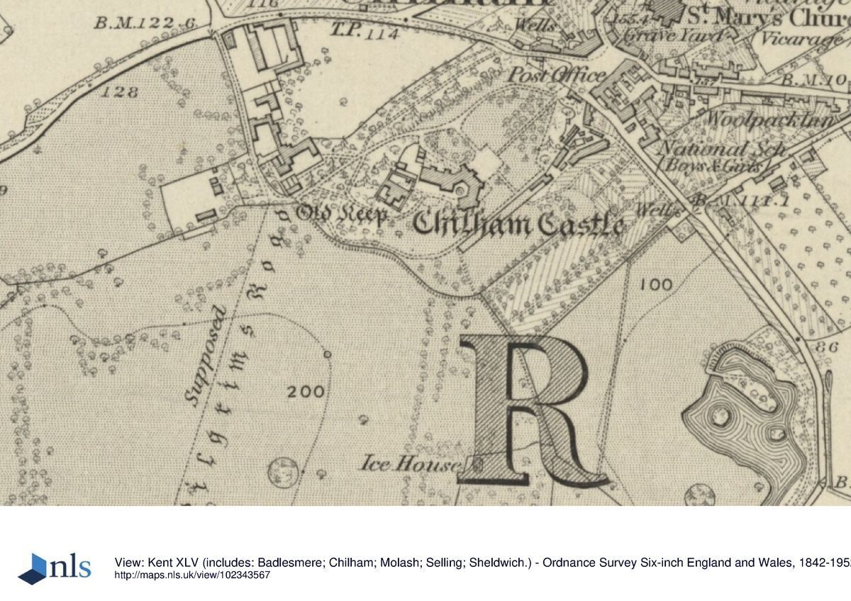
The house known as Chilham Castle (listed grade I) commands extensive views south-eastwards over the distant landscape from its position on level ground on the edge of the valley of the Great Stour river. The house, of red brick with ashlar dressings and a tiled roof, was built between 1603 and 1616. It is hexagonal in plan, with a central courtyard opening to the south-west. The north-east, entrance front is of two storeys while the corner turrets and the gabled entrance porch are both of three storeys. The east front was altered by James Colebrook in the mid C18 and the house refitted by Thomas Heron in the late C18. Considerable alterations were carried out by David Brandon for Charles Hardy in 1861-3 when the north-west wing was also added. From 1922, Sir Herbert Baker restored the house and added the banqueting house to the C19 wing. To the immediate west of the house is the octagonal keep and curtain walls of the C12 Chilham Castle (listed, with the donkey wheel, grade I). Built of Caen stone and flint, these survive from its construction in 1171-4 and subsequent demolition after 1542. It is framed and largely obscured on the west and south sides by trees and shrubbery, and was restored to its present appearance and occupancy as a dwelling in the early C20.
GARDENS AND PLEASURE GROUNDS
The formal and ornamental gardens lie to the south and east of the Castle. The courtyard on the south-west front, laid out with a small circular pond set in a surround of paving and box hedging (shown apparently newly completed in photographs of 1924, CL), opens onto a south-west-facing lawn which terminates, 120m distant, in a curving, 250m long brick-walled ha-ha (listed grade II), built as part of Lancelot Brown's improvements in c 1777 (Stroud 1975). On the lawn 30m south of the courtyard is an C18 sundial by Thomas Wright (listed grade II).
A series of four formal terraces (listed grade II), 110m long and constructed of red brick, opens off the south-east front of the Castle. The top terrace, built in 1922 to replace the former gravelled walk and grass slope, carries the lawn around from the south-west front to the entrance front. At the second and third levels, a central grass walk is flanked by a herbaceous border against the retaining wall while on the south-east side of the second level is a line of topiary yews in a variety of shapes, planted in 1922 (CL 1924). These two terraces would appear to be those reconstructed in the early or mid C19 by James Colebrook (guidebook) on the site of those probably laid out by John Tradescant the Elder and removed during improvements by Brown after 1777. Tradescant's terraces are described as being seven or eight of sloping ground, divided by walls and laid out with box beds and paths (ibid) although an unattributed view of 1777 (ibid) appears to show them fewer and level in character. The present terraces are linked at their south-west end by several flights of brick steps, part of Baker's 1922 restoration, built into the slope of the lawn, the bottom flight giving access to the fourth, lowest terrace. This comprises a broad lawn, laid out as a bowling green in the early or mid C19 and retained on the south-east side by a C17 wall (which survived Brown's improvements) topped by a line of large topiary yew spirals and unclipped pairs of Irish yews, planted 1870-90 (ibid).
South-east below the terraces is a further walled enclosure, now laid to rough grass with a few mature fruit trees and abandoned tennis courts, which is shown laid out, probably as an orchard, with rows and a central avenue of small trees on the OS 1st edition (1877) and early C20 photographs (private collection).
Abutting the terraces to the north-east is the small rectangular Quiet Garden, enclosed by tall yew hedges, with a rockwork entrance arch at the south-west corner shaded by a grove of mature beech and lime trees underplanted with spring bulbs. North-east of the Quiet Garden and enclosed by high brick walls is a range of glasshouses and outbuildings, shown established on the OS 1st edition (1877). From a central gap in the wisteria-clad south-east wall an axial grass path slopes south-eastwards, through a rose garden with ancient mulberry trees along its south-west side and beyond into an orchard with a small nuttery overlooked by the late C18 Elephant House (now known as Annagh House, listed grade II) built against the estate wall. A grass path from the south-east end of the orchard leads, via an area of ornamental woodland, shrubbery, and an early C20 overgrown rockery, to the lake, now (1997) largely hidden from view by bankside planting. The lake, which was constructed in 1869 for Charles Stewart Hardy on land brought into the park in c 1733, contains islands, the largest of which is connected to the north-west shore by a three-arched brick bridge (listed grade II). To the west are lawns with mature trees, planted in the early C20 on a former part of the adjacent paddock.
PARK
The parkland extends for c 1.3km to the south and south-west of the gardens, rising gently up the side of the river valley from north-east to south-west but with falling ground in the south-east corner. The park is medieval in origin but its early history is unclear. It was enlarged to near its present size in the early or mid C18 when James Colebrook diverted both the Canterbury to Ashford road, to enclose land to the north-east (the site of the present lake), and, in 1733, the Dane Street to Godmersham road which added a further 200 acres (c 81ha) in the south-west (guidebook). These extensions appear to be substantiated by the boundaries shown on Andrews, Dury and Herbert's map of Kent of 1769. A further strip of land, part of which is now (1997) occupied by Chilham Vineyard, was added along the present north-west boundary between 1769 and 1870 (OS 1877) after the realignment westwards of the A20.
The open areas of the park are largely laid to pasture. South-westwards from the Castle, and extending almost to the park boundary, there is a long vista down a central band of open parkland, set with one or two major clumps and with individual trees. Lancelot Brown is known to have been called in by Thomas Heron in 1777 (Stroud 1975) but, apart from the ha-ha, the extent of his work in the park is unknown. The vista is framed by the numerous belts of trees on the north-west side of the park and, on the south-east side, by a c 1km long avenue which begins at the ha-ha. There are further tree belts along the east and south boundaries. The present general pattern of tree planting, which is of mixed age and which suffered considerable losses in the storm of 1987, is shown established on the OS 1st edition map surveyed 1871-2, although the southern c 600m of the avenue, which is largely of oak and lime, appears to have been planted as an extension of the northern c 400m section, which is of sweet chestnut, between 1872 and 1898 (OS 1877, 1898). The chestnut avenue, which contains several trees of immense girth (up to 9.5m) in the section closest to the ha-ha, appears to be shown on Andrews, Dury and Herbert's county map of 1769.
REFERENCES
J P Neale, Views of the Seats ..., 2nd series ii, (1825)
Country Life, 5 (25 March 1899), pp 368-71; 32 (27 July 1912), pp 120-33; 55 (24 May 1924), pp 812-19
J Newman, The Buildings of England: North-east and East Kent (1969), pp 318-19
D Stroud, Capability Brown (1975), pp 219-20
T Wright, Gardens of Britain 4, (1978), pp 28-30
Chilham Castle, guidebook, (1987)
Maps
J Andrews, A Dury and W Herbert, A Topographical Map of the County of Kent , 2" to 1 mile, 1769
W Mudge, Map of Kent, 1" to 1 mile, 1801
OS 6" to 1 mile:
1st edition surveyed 1871-2, published 1877
2nd edition published 1898
3rd edition published 1908
1938 edition
OS 25" to 1 mile:
3rd edition published 1907
1937 edition
Archival items
Chilham Castle, Eighteen Reproductions of Watercolour Sketches made by Miss Emily Wildman ¿ prior to 1862, with notes by Arthur Bolton (Centre for Kentish Studies, Maidstone)
Several unattributed guidebooks of various dates (Centre for Kentish Studies, Maidstone)
Photographs of Chilham Castle, 1919 (private collection)
Description written: May 1997
Amended: January 1999
Register Inspector: VCH
Edited: October 2003
- Visitor Access, Directions & Contacts
Telephone
44 1227 733100Directions
The site is just west of the village of Chilham, 9 miles west of Canterbury and 8 miles east of Ford.
- History
The house is Jacobean with a garden of essentially formal character, having terraces, walks, a rose garden and specimen trees. Examples include holm oak (Quercus ilex) on the front lawn and avenues of sweet chestnut (Castanea sativa) and limes. There is also a more remote, relatively wild informal area with a lake, rock and water gardens.
Capability Brown was called in in 1760. His visit was brief but he was thought to have advised on the siting of the lake, landscaping of the park and the introduction of the ha-ha.
There have been Victorian and Edwardian additions, mainly the rock garden and wild garden.
Major restoration work took place from 1918-30.
Recent research by Brian Thomas (the Managing Agent) indicates that Brown did not apparently make the lake as was always supposed. The date of the lake seems to be in the 1920s.
The following is from the Register of Parks and Gardens of Special Historic Interest. For the most up-to-date Register entry, please visit the The National Heritage List for England (NHLE):
www.historicengland.org.uk/listing/the-list
HISTORIC DEVELOPMENT
A Norman castle was established at Chilham in the C11 and completed in the late C12. It passed through the hands of several owners until acquired in the early C17, through marriage, by Sir Dudley Digges who built the present, adjacent house and employed John Tradescant the Elder (d 1637) to lay out the gardens (guidebook). After Digges' death in 1638 the property remained in the family until sold in 1724 to James Colebrook who enlarged the park to both the south-west and north-east. Colebrook's son sold the estate in 1724 to Thomas Heron who engaged Lancelot Brown (1716-83) to improve the park. Just before Heron's death in 1794 the estate was acquired by James Wildman; his son, James Beckford Wildman, succeeded in 1816, rebuilding some of the terraces removed in Brown's improvements before selling the estate in 1861 to Charles Hardy. In 1867 he was succeeded by his son, Charles Stewart Hardy who built the stables and constructed the lake. He died in 1914 and in 1918 Chilham Castle became the property of Sir Edmund Davis who employed Sir Herbert Baker to restore the house and formal gardens. After Sir Edmund's death, the estate was owned for five years by Mr Somerset de Chair and, from 1949 until its sale in 1997, by Viscount Massereene and Ferrard. The estate remains (1997) in private hands.
Period
Medieval (1066 to 1540)
- Associated People
- Features & Designations
Designations
The National Heritage List for England: Register of Parks and Gardens
- Reference: GD1175
- Grade: II*
Features
- Garden Terrace
- Lake
- House (featured building)
- Description: The house is Jacobean with a garden of essentially formal character.
- Earliest Date:
- Latest Date:
- Walk
- Rose Garden
- Tree Avenue
- Description: The great lime avenue leading to the east entrance of the house was destroyed in the 1987 storm and re-planted in 1988.
- Earliest Date:
- Latest Date:
- Planting
- Description: Rock garden.
- Planting
- Description: Wild garden.
- Tree Avenue
- Description: The old avenue of limes and sweet chestnuts of possible early 17th-century date was seriously damaged in 1987.
- Earliest Date:
- Latest Date:
- Specimen Tree
- Description: The ancient holm oak (Quercus ilex) on the front lawn largely survived the 1987 storm, due it is thought to extensive tree surgery a few years previously.
- Deer Park
- Ornamental garden
- Formal garden
- Castle
- Key Information
Type
Park
Purpose
Ornamental
Principal Building
Domestic / Residential
Period
Medieval (1066 to 1540)
Survival
Part: standing remains
Hectares
130
Open to the public
Yes
Civil Parish
Chilham
- References
References
- Smithers, David Waldron {Castles in Kent} (Chatham: John Hallwell Publications, 1980) Castles in Kent
- {English Heritage Register of Parks and Gardens of Special Historic Interest}, (Swindon: English Heritage, 2008) [on CD-ROM] Historic England Register of Parks and Gardens of Special Historic Interest
- Stroud, D., {Capability Brown} (London: Faber, 1975), p. 318-9 Capability Brown
- Wright, Tom {The Gardens of Britain 4: Kent, East & West Sussex and Surrey}(London: Batsford, 1978) The Gardens of Britain 4: Kent, East & West Sussex and Surrey
- Kent County Council Planning Department {The Kent Gardens Compendium} (Canterbury: Kent County Council, 1996) 26 The Kent Gardens Compendium
- Newman, J. and Pevsner, N. {The Buildings of England: North East and East Kent} (Harmondsworth: Penguin, 1976) The Buildings of England: North East and East Kent
- Oswald, Arthur {Country Houses of Kent} (London: Country Life, 1933) Country Houses of Kent
- Alexander, M., (NHLE entry 1000261), (2022) Chilham Castle site report
Contributors
Kent Gardens Trust
Surveys
- Related Documents
-
CLS 1/629
Restoration Plan and Countryside Stewardship Application - Hard Copy.
Liz Lake Associates - 2003
-
CLS 1/630/1 - 4
Appendix A (Figures) Appendix C (Nature Conservation) - Hard Copy.
Liz Lake Associates - 2004
-
CLS 1/631
1) Blue Skies Plan, Sept 2003 with 2) rationale by Kate Felus, annotated by J.Phibbs, and 3) the latter's considered thoughts, typed out. Also 4) letter from Liz Lake to Mr and Mrs Wheeler enclosing copies of the Blue Skies Plan - Hard Copy.
Debois Landscape Survey Group and Liz Lake Associates - 2003
-
CLS 1/629