Introduction
Lower Brockhampton is a medieval timber-framed house with gatehouse and garden.
www.historicengland.org.uk/listing/the-list
A mid C18 landscape park associated with a country house.
DESCRIPTION
LOCATION, AREA, BOUNDARIES, LANDFORM, SETTING
Brockhampton lies 4km east of Bromyard, on the east side of a ridge separating it from the River Frome and Bromyard beyond. The park (c 137ha) is bounded to the south by the main A44 Bromyard to Worcester road and is screened from it, east of Bromyard Lodge, by a stone wall constructed in 1816, c 3m tall west of Worcester Lodge and c 2m tall east of it. The wall also extends for c 200m down the east side of the park, which adjoins Bringewood Common. The local topography is intimate, with well-folded low hills, brooks, and woods. The northern boundary of the park follows Hyde Dingle, down which flows a tributary of the Sapey Brook, which itself drains into the River Teme 4km east of Brockhampton.
ENTRANCES AND APPROACHES
The main approach by visitors to Lower Brockhampton and to the park at Brockhampton in the late C20 was via the Top Drive off the A44, at the south end of which is Bromyard Lodge, a modest stone villa-style building of 1850. That drive, well planted to either side with mature specimen trees, leads directly to the south-west side of the pleasure grounds and kitchen garden before turning round the east side of the latter to approach the main, south front of the House. The drive first appears on a survey of 1829 (National Trust 1989).
The private approach to the House in the late C20 was via a second drive off the A44, the Lower Drive. That leads north-west to the House, and has at its end Worcester Lodge (listed grade II*), which has a dramatic Tuscan columned and pedimented facade reputedly modelled on the east front of Covent Garden church. The architect may have been George Byfield (c 1756-1813), designer of Brockhampton's new chapel in 1799. Tree dating suggests the drive's line was established in the 1760s, presumably when the site of the new house was decided upon.
PRINCIPAL BUILDING
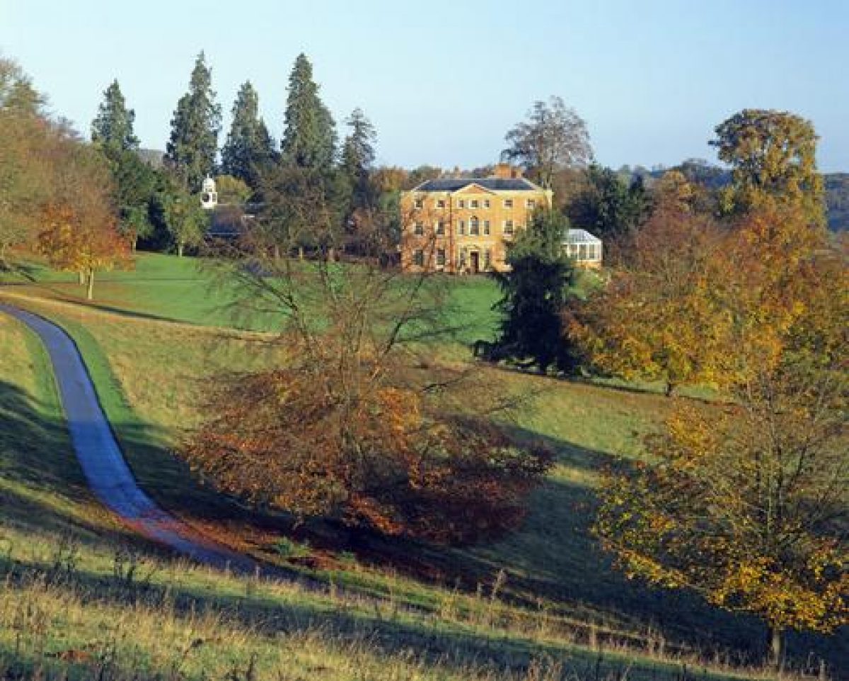
Brockhampton House (listed grade II*; also referred to in earlier sources as Brockhampton Court, or Park) is of brick, and has its principal front to the south; that is of seven bays, the centre three surmounted with a pediment. The architect was Thomas Farnolls Pritchard (1723-77). It lies on a slight spur, previously occupied by a farmhouse called The Hill, from which the ground falls away to the south and east. Work seems likely to have been financed by Betty Freeman's marriage portion, and by monies released on the death of her father in 1764. About 1870 the House was remodelled internally and new window architraves applied to the exterior. An extensive restoration was undertaken in 1982 and in 1996-7.
Immediately to the north-west of the House is an C18 stables and service courtyard (listed grade II), converted c 1967 to private housing (Brockhampton Mews).
Brockhampton Chapel (listed grade B) lies south-west of the kitchen gardens. It was built in a neo-Perpendicular style to a design of 1799 by George Byfield to replace a Norman chapel at Lower Brockhampton.
GARDENS AND PLEASURE GROUNDS
The principal element of the garden is an elaborate parterre before the east front of the House, reinstated in 1996, closely following the lines of one designed in 1865 by 'Aer Roo[e]s', that is Alexander Roos who is well documented as a garden designer in Scotland in the 1840s. Other works in 1996 included the planting of box hedging and the renewal of paths, both closely following a drawing by Alexander Roos. Broderick Thomas had submitted alternative designs in 1864 (National Trust 1989), which Roos' design superceded.
Immediately outside and to the east of the kitchen gardens is a grotto-like Rockery built of local tufa. Perhaps late C19 the Rockery includes a niche with rustic wooden seat.
PARK
South and east of the House the ground falls away. It, like most of the parkland, is well studded with mature specimen trees, principally deciduous but with occasional conifers especially south-east of Brockhampton Chapel. The ground also falls steeply away north and west of the House towards Look-out Wood and Yeld Wood, which occupy the western part of Hyde Dingle. A metalled drive from the west side of the kitchen garden runs down into the west end of the Dingle (passing earthworks south of the drive of field boundaries, a hollow-way, and a carriage drive) before turning to run north-east up the inner edge of the Dingle towards Lower Brockhampton.
The eastern half of the park is well wooded (Hyde Wood, Yewtree Bank, Holy Bank, Runaway Bank, all managed under a Dedication Agreement with the Forestry Commission), and is overlooked from the House. Woodland walks were developed through these woods by the National Trust in the late C20. At the south end of the woodland, 400m south-east of the House, is the triangular Lawn Pool. Thomas Leggett, who drew up a design (unexecuted) for the park dated 1769 (National Trust 1989), proposed a serpentine lake here, and it is unclear if the Pool was created c 1770 or represents a pre-existing feature in the landscape. A boathouse shown on late C19 maps had gone by 1996. A smaller pool, Hyde Pool, towards the east end of Hyde Dingle, was inadvertently drained in 1946 and remained dry in the late C20.
The only other water in the park is Park Pond, a small circular pool on the west side of the drive from Bromyard Lodge 100m south of Brockhampton Chapel.
Broad shelter belts screen the west boundary of the park and the western half of that to the south.
Although the 1769 plan was signed by Thomas Leggett, cartographically it is in the style of the better-known designer William Emes (1730-1803), with whom Leggett is known to have worked elsewhere. For the moment it remains unknown who was responsible for the park layout. Overall, the evidence suggests that the park was created in piecemeal fashion from the 1760s following the commissioning of the new house, with both Bartholomew Barneby (d 1783) and his son John planting and taking out field boundaries. By 1829 the park comprised c 100 acres (c 40ha), mainly east of the House, and was walled and had a lodge. Areas west and south of the House later to be taken into the park were then mainly arable land, orchard, or hop ground; by 1885 these areas had become more park-like.
KITCHEN GARDEN
The large, roughly elliptical, brick-walled kitchen garden lies 100m south-west of the House. It is effectively screened both from the House and from the approach drives by a 2m tall stone outer screen wall with planting behind. Curved garden walls are a local feature and occur also at Clater (immediately south of Brockhampton), another Barnaby residence, and at the White House, Suckley, which belonged to Betty Barneby's brother. The main range of glass, with heated wall, lay along the north wall. All the Victorian glass was ruinous by the mid 1980s when it was reconstructed in a modern form as a dwelling (designed by Associated Architects of Birmingham). In the mid 1990s the area between the inner and outer garden walls at the west end of the site was converted to a car park.
The basic structure of the kitchen garden seems likely to date from the 1770s.
REFERENCES
J Duncomb, Collections Towards the History and Antiquities of Hereford ii, (1812), p 70
Brockhampton Park Survey, (National Trust 1989)
Country Life, no 1 (4 January 1990), pp 46-51
S Daniels and C Watkin, The Picturesque Landscape (1994), pp 22-3
Maps
OS 6" to 1 mile: Herefordshire sheet 21 NE, 1st edition published 1885
OS 25" to 1 mile: Herefordshire sheet 20.7, 2nd edition published 1904
Archival items
Designs by Alexander Roos and Broderick Thomas (National Trust)
C20 estate records (M5B/5), (Herefordshire Record Office)
Description written: 1998
Register Inspector: PAS
Edited: August 1999
- Visitor Access, Directions & Contacts
Telephone
0844 800 1895Website
http://www.nationaltrust.org.ukAccess contact details
Opening times for the Brockhampton Estate vary seasonally. Please see the website for details. However, the 18th-century house known as Brockhampton Park is let privately to a tenant and is NOT OPEN TO THE PUBLIC.
Directions
Two miles east of Bromyard on the A44.
Owners
The National Trust
Heelis, Kemble Drive, Swindon
- History
The mediaeval house now known as Lower Brockhampton was built around 1400, and retains elements of an early garden layout including the contemporary gatehouse.
In 1946 John Talbot Lutley left the estate in his will to the National Trust.
The following is from the Register of Parks and Gardens of Special Historic Interest. For the most up-to-date Register entry, please visit the The National Heritage List for England (NHLE):
www.historicengland.org.uk/listing/the-list
HISTORIC DEVELOPMENT
In the early 15th century John Dumulton was lord of the manor of Brockhampton, and he or his heir is the likely builder of the timber-framed Brockhampton Manor, which lies just outside the north boundary of the 18th-century park. Subsequently the manor passed to the Habington family, an heiress of which married Thomas Barneby, of Bockleton (Worcestershire), whose family was to own Brockhampton for the next 400 years. In 1756 Bartholomew Richard Barneby (died 1783), who had come into the estate in 1731, married Betty Freeman. It was probably her marriage portion of £3000, and in due course money inherited from her father, that allowed a new house to be built on high ground 1km south of the old manor house, and a landscape park to be created. The estate descended in the family until 1946 when John Talbot Lutley bequeathed it to the National Trust. While Lower Brockhampton was opened to the public Brockhampton House was emptied of its contents, extensively restored, and later suffered a chequered history before being leased around 1982 to a developer. A thorough restoration of both house and grounds followed its passage to a new tenant in 1996.
- Features & Designations
Designations
The National Heritage List for England: Register of Parks and Gardens
- Reference: GD1872
- Grade: II
Features
- Gatehouse
- Earliest Date:
- Latest Date:
- Manor House (featured building)
- Earliest Date:
- Latest Date:
- Moat
- Key Information
Type
Estate
Purpose
Ornamental
Principal Building
Domestic / Residential
Survival
Extant
Hectares
137
Open to the public
Yes
Civil Parish
Brockhampton
- References
References
- A Survey of Historic Parks and Gardens in Herefordshire
- {English Heritage Register of Parks and Gardens of Special Historic Interest}, (Swindon: English Heritage, 2008) [on CD-ROM] Historic England Register of Parks and Gardens of Special Historic Interest