Introduction
Antony has late 18th-century gardens of 30 hectares, which were extensively replanted in the 20th century. The gardens lie within a larger estate of park, woodland and agricultural land. The estate is now in divided ownership, the house and about 12 hectares of the gardens belonging to the National Trust.
Terrain
The site is undulating, with a generally gentle slope from the south towards the river to the north. Steep-sided valleys run from south to north to the west and north-east of the house.www.historicengland.org.uk/listing/the-list/
18th-century gardens, pleasure grounds, and a park for which Humphry Repton produced a Red Book in 1792, together with 20th-century gardens and woodland pleasure grounds.
DESCRIPTION
LOCATION, AREA, BOUNDARIES, LANDFORM, SETTING
Antony is situated c 1km north-west of Torpoint, to the north of the A374 road and on the south shore of the St Germans or Lynher River to the west of its confluence with the Hamoaze. The c 130ha site comprises some 30ha of gardens and pleasure grounds, and c 100ha of parkland and plantations through which passes a circuit of drives and rides. To the north the site is bounded by the tidal foreshore of the St Germans or Lynher River, while to the east, south, and west the site adjoins agricultural land. The south-east boundary is formed by a minor road, Wilcove Lane, domestic properties in the hamlet of Maryfield, and the mid C19 church of SS Philip and James. A minor road, Ferry Lane, crosses the site from south-east to north-west to reach Jupiter Point c 400m north-north-west of the house. The site is undulating, with a generally gentle slope from the south towards the river to the north. Steep-sided valleys run from south to north to the west and north-east of the house, while the ground rises into several prominent hills including Jupiter Point, Tomboy Hill, and Great Kithill. There is a series of vistas cut through woodland north of the house and gardens to the river, while from the riverside walks and high ground such as Jupiter Point there are views across the river to the keep of Trematon Castle, and to Ince Castle.
ENTRANCES AND APPROACHES
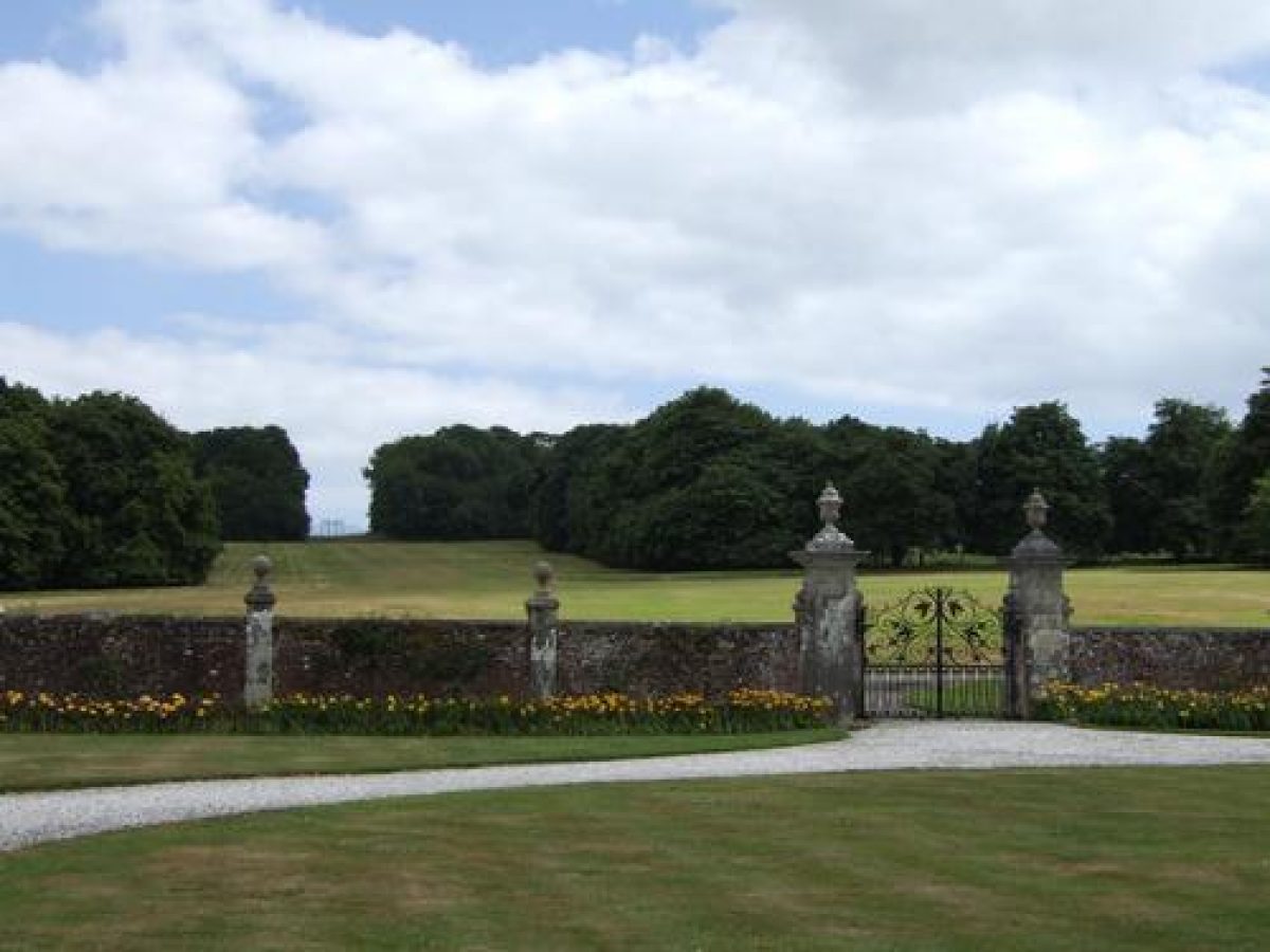
Antony is approached from the A374 road to the south at a point c 80m south-west of its junction with a minor road leading north to Maryfield. The entrance is set back from the road behind a triangular area of grass, and is marked by an early C19 single-storey stone lodge and an attached pair of rusticated stone piers surmounted by pineapple finials flanked by low quadrant stone walls (all listed grade II). The lodge is square on plan with a pyramidal roof, while areas of lawn to the east and west of the entrance are planted with mature ilex oaks. The design of the lodge is attributed to John Adey Repton (1775-1860) (guidebook), while the position of the entrance corresponds to that suggested by Humphry Repton (Red Book 1792). The drive to the north of the entrance also serves as a public road, Ferry Lane, leading to a former public ferry across the River Lynher. The road sweeps north and north-west through the park for c 530m to reach a junction with a drive which leads c 130m south-west across the park before turning north-west for c 100m to reach the forecourt to the south-east of the house.
The forecourt is enclosed to the south-east by a brick wall supported by regularly spaced stone piers surmounted by ball finials. Centrally placed stone piers surmounted by vase finials support a pair of wrought-iron gates with scrolled and leaf decoration which provide access to the forecourt which is laid out with a central circular lawn and a gravelled carriage turn. To the north-east and south-west the forecourt is enclosed by a symmetrical pair of arcaded two-storey brick pavilions which are flanked by further single-storey arcades terminating to north and south in small pavilions surmounted by ogee lead domes. The walls, gates, arcades, and pavilions forming the forecourt are all listed grade I. The design of the forecourt has been attributed to James Gibbs and is shown in its present form in an anonymous painting of c 1720 (guidebook). A statue shown standing on a plinth at the centre of the forecourt in this painting was removed by 1758 (Borlase); it was subsequently replaced by a stone baluster sundial which was in turn removed in the mid C20. Humphry Repton recommended that the south-east screen wall of the forecourt should be removed to open it to the parkland south of the house (Red Book 1792) but this was not implemented.
To the south-east of the forecourt a wide avenue of horse chestnuts ascends a north-west-facing slope for c 200m to reach a late C19 wrought-iron clairvoie (listed grade II) which closes the vista on the skyline. Modelled on a C17 gate screen at Beddington Manor, Surrey which had belonged to Sir Nicholas Carew, the clairvoie was originally placed at the north end of the late C19 formal garden north of the house; it was moved to its present position by Philip Tilden in 1948. The chestnut avenue was planted by Sir Reginald Pole-Carew in the early C20 as part of a projected south approach; this remained incomplete in 1914 and was abandoned after the First World War.
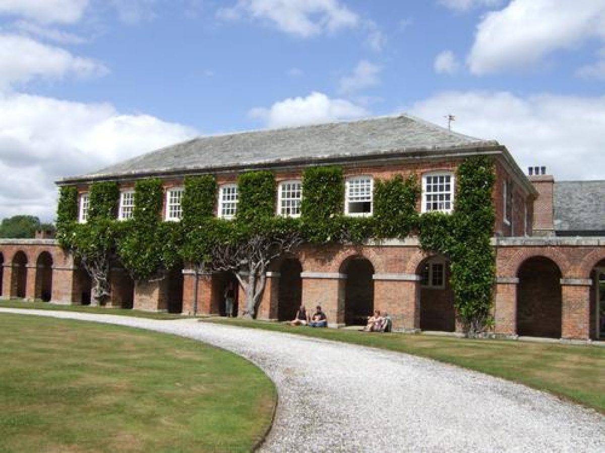
To the north of the drive leading to the forecourt, Ferry Lane continues north-west for c 270m to reach a junction with a service drive which leads south-west to reach the early and mid C18 stables and service buildings north-east of the house and forecourt (all listed grade II). North-west of this drive Ferry Lane forms the boundary between the pleasure grounds and park, and extends c 350m to a point where it is crossed by a carriage drive which leads east into the park and west into the pleasure grounds. To the west of this junction a two-storey picturesquely gabled late C19 stone lodge, Broomhill Cottage, stands in the pleasure grounds. Ferry Lane descends c 200m north-west beyond this junction to reach the quay at Jupiter Point, where a further early C19 two-storey stone lodge (listed grade II) stands to the west of the drive. The design of this lodge has been attributed to John Adey Repton (guidebook).
PRINCIPAL BUILDING
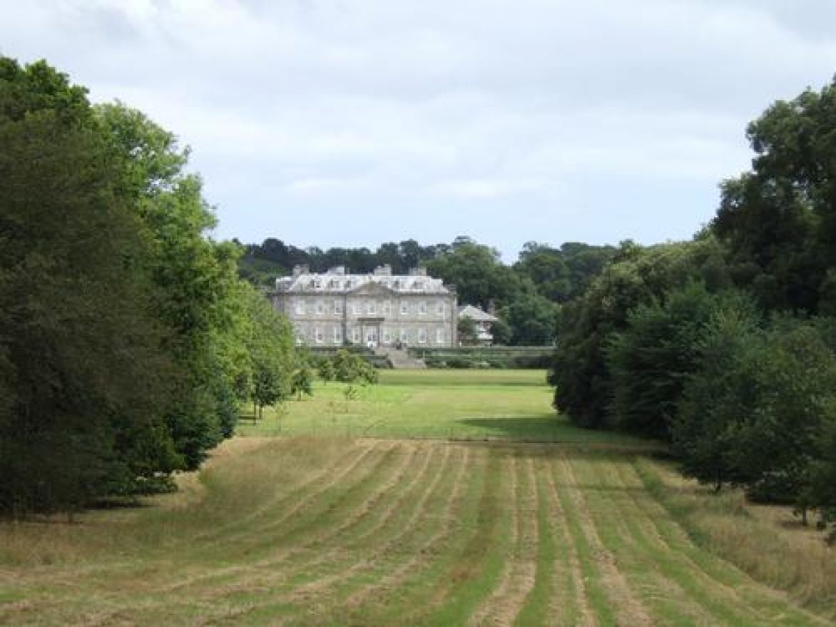
Antony House (listed grade I) stands on an artificially levelled terrace towards the centre of the site overlooking a gentle north-facing slope which descends to the River Lynher. The house is approximately rectangular on plan and comprises two storeys under a hipped slate roof with pedimented attic dormers; it is constructed in brick faced with Pentewan ashlar. The south-east or entrance facade has a central pediment three bays wide, below which is a mid C19 single-storey porte-cochere supported by Tuscan columns; this was constructed by William Henry Pole-Carew. The north-west or garden facade survives in its original early C18 form.
The house was built for Sir William Carew, fifth Baronet in 1718-29 by the mason John Moyle, perhaps following his own design or one provided by James Gibbs (ibid). A design included in Gibbs' Book of Architecture (1728) has been identified as corresponding to Antony. A simple two-storey Italianate wing was added to the north-east of the C18 house for William Henry Pole-Carew in the mid C19; this was replaced by a neo-Jacobean wing in stone and red brick which was constructed for Sir Reginald Pole-Carew in 1905. This wing was in turn removed by Philip Tilden in 1948.
GARDENS AND PLEASURE GROUNDS
The gardens and pleasure grounds are situated principally to the north-west and west of the house and comprise formal terraces and lawns adjacent to the house, together with informal pleasure grounds and woodland gardens.
A wide flight of stone steps descends from a centrally placed door on the north-west facade of the house to reach a gravelled terrace which extends the full width of the building. The terrace is terminated to the north-east by a flight of stone steps which descends to a small Japanese garden comprising a pool, rockwork, specimen shrubs, and oriental ornaments; this garden was created by Lady Beatrice Pole-Carew c 1910. To the south-west the axis of the terrace is continued for c 130m by the Yew Walk, a grass walk enclosed by buttressed yew hedges c 3m high. The walk is terminated by a stone bench seat; early C20 stone-flagged edgings and herbaceous borders which flanked the walk do not survive. Opposite the garden door a flight of stone steps descends to a lower terrace which comprises a gravel walk bordered by narrow lawns; the walk is terminated to north-east and south-west by bench seats set against yew hedges. A narrow border extends below the buttressed red-brick retaining wall of the upper terrace. A further flight of stone steps aligned with the garden door descends from the second terrace to a gravel walk which is terminated to north-east and south-west by clipped yew alcoves which both contain curved timber seats. Mixed borders are planted below the brick retaining wall of the middle terrace. Below the terraces lawns extend north to the pleasure grounds, where a vista, Shillingham Glade, extends to the river; this corresponds to a ride shown on Repton's Red Book plan (1792). Gravel walks extend north-west and north across the lawns to reach the pleasure grounds, while c 30m north of the house stands an early C18 circular stone dovecote (listed grade II*).
The formal gardens north of the house were constructed c 1900 for Sir Reginald Pole-Carew, perhaps to the design of H Inigo Triggs (CL 1933), and originally included a series of geometrical compartments and beds with topiary yews and stone-flagged walks on the lawn below the surviving lowest terrace walk. The formal garden was enclosed by low brick walls with a semicircular projection to the north-west closed by the wrought-iron screen which now terminates the chestnut avenue south-east of the house. This formal garden was reduced and simplified for Sir John Carew Pole in 1948 by Philip Tilden; the outline of the lower garden remains visible in the lawn. The early C20 formal garden recalled the early C18 formal garden constructed north of the house for Sir William Carew by Humphry Bowen of Lambeth, and occupied approximately half the area of the C18 garden. The C18 garden was also enclosed by brick walls, and survived until 1792 when Repton recommended that it should be removed and replaced by lawns with trees and shrubberies framing the views to the river and Jupiter Hill; this proposal was implemented during the 1790s. Mid C19 photographs (private collection) indicate that at that time a balustraded terrace extended below the facade of the house.
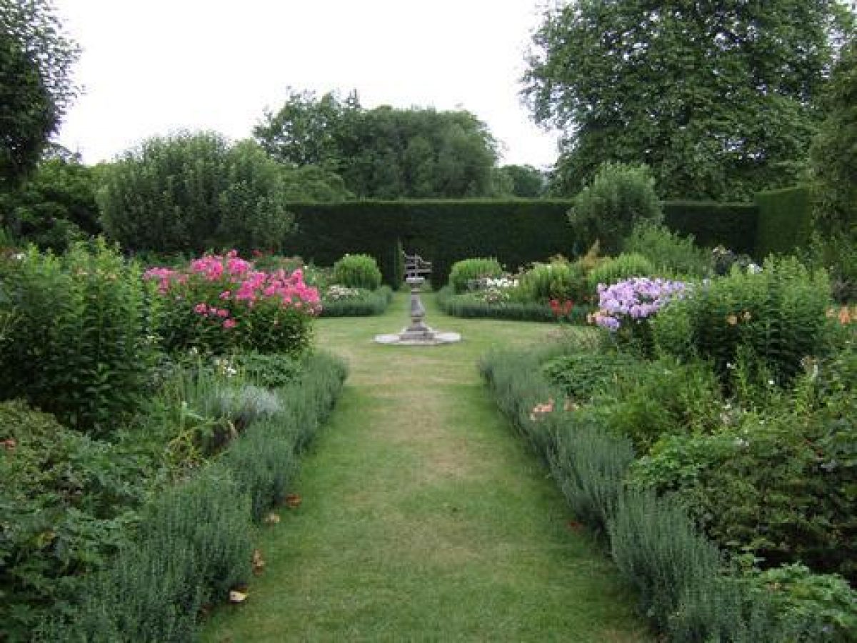
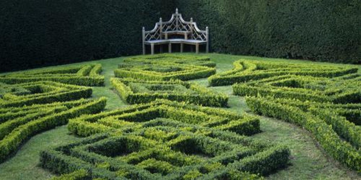
To the south-west of the house a rectangular lawn is crossed by three stone-flagged walks which intersect at a circular pool. Stone steps ascend from this lawn to a formal gravel walk which leads c 150m south-west from the house to an ogee-roofed pavilion. The bell was acquired by Sir Reginald Pole-Carew in 1886, while the lanterns were introduced by Sir Reginald in 1910. To the north-west the walk is enclosed by the yew hedge forming the south-east side of the Yew Walk, while c 80m south-west of the house a monumental conical clipped yew forms an arbour overlooking the site of a C19 tennis lawn to the south-east. To the south-east of the walk is an area of lawns planted with C19 and C20 specimen trees and shrubs. North-west of the Yew Walk and north-east of the kitchen garden an approximately rectangular area enclosed by yew hedges was laid out in the late C20 as two formal gardens to the design of Lady Carew Pole, that to the south being a summer garden with geometrical herbaceous borders, and that to the north a parterre with low box and herb hedges. Some 270m south-west of the house and immediately south-west of the kitchen garden a small late C19 and C20 dogs' cemetery is situated in an area of evergreen shrubbery.
Between the lawns and the River Lynher is an area of informal pleasure grounds comprising six radiating vistas or rides which allow a series of views of the water and Jupiter Hill. Mature woodland is underplanted with specimen shrubs, including an extensive C20 collection of rhododendrons, camellias, and magnolias. Some 530m north-north-west of the house, Jupiter Hill or Point is a steep-sided rocky hill, the summit of which is approached from the north by a serpentine walk through ornamental shrubbery and ilex oaks. A former quarry is situated on the south side of the hill. A granite plinth formed the base for the figurehead of the Jupiter which was acquired by Reginald Pole-Carew and placed on the hill c 1780; its remains were removed c 1950. Repton's plan (1792) indicates the reciprocal vista between the house and Jupiter Point, while he recommended the establishment of woods of ilex oak to the north of the hill. In the early C20 a rock garden was created on the slopes of Jupiter Point for Lady Beatrice, wife of Sir Reginald Pole-Carew; this does not survive today. Some 530m north-west of the house, the Bath House (listed grade II) stands to the south-west of a tidal pond which was formed in a former quarry. The pond feeds the bath which is open to the sky and situated in a low wing to the west of the main single-storey structure which contains changing rooms. The Bath House was built to the designs of the Devonport architect Thomas Parlby in 1788-90, and formed part of Reginald Pole-Carew's improvements to the grounds prior to his instruction of Repton in 1792; the Bath House and its associated pond is shown on Repton's plan of 1792, and the pond appears to have been constructed by Humphry Bowen in the early C18 (estate accounts). To the west of the Bath House a marshy area known as the Salt Pans was formerly used to collect salt; it is shown as a lake on Repton's plan (1792). A valley above the Salt Pans contains a series of ponds fed by a small stream; the surrounding area is planted with ornamental shrubs and conifers. Lower Westdown Wood c 400m north-west of the house is cut by three radiating vistas or rides, Wivelscombe Glade, Ince Glade, and West Glade; this area is shown as open parkland on Repton's plan (1792). The glades were created in the early C20 by Sir Reginald Pole-Carew when an existing coastal plantation was extended inland (OS 1888, 1907). A further valley, Middle and Higher Westdown extends from south-east to north-west on the south-west boundary of the site, with mature deciduous woodland underplanted with camellias, magnolias, and rhododendrons. This area was developed as a woodland garden by Sir John Carew Pole in the mid and late C20.
The informal pleasure grounds were created by Reginald Pole-Carew in the late C18 and early C19, in part developing an existing area of woodland known as the Wilderness c 400m north-west of the house; this had originated as a wilderness associated with the early C18 formal gardens laid out for Sir William Carew by Humphry Bowen.
PARK
The park is situated principally to the north-east and east of the house, and is separated from the pleasure grounds by Ferry Lane. There is a further area of park and paddocks to the south-east of the house. The park remains pasture with scattered, predominantly broadleaved trees, and is divided into a series of grazing enclosures. Plantations extending along the foreshore from Jupiter Point east to The Cove contain a series of rides or carriage drives from which there are views across the river towards Saltash and the Tamar bridges. A lime avenue extends c 270m north-east of the house up the south-facing slope of Tomboy Hill; this was planted in two stages, in the early and late C20. Some 400m north-east of the house a wooded valley extends north-north-east to the river. Its east-facing side, known as Long Orchard, is today deciduous woodland which it is believed contains the site of the medieval manor house of the Carews, and, c 530m north-east of the present house, the ruins of a stone dovecote associated with the manor house. Orchards were growing in this area in the C16 and C17 (Gill nd). At the lower end of the valley an informal pond formed by damming the mouth of a tidal inlet contains a square island. Originally a salt-water pond used for trapping sea fish, the pond was constructed in the mid C16 by Richard Carew who called it his 'Fishful Pond' and described it in his Survey and in verse. Carew's pond contained a square island with rounded projections at each corner which was inspired by the plan of the house at Mount Edgcumbe (qv); a banqueting house of similar plan was projected for this island, but was never realised (ibid). The present pond and island were restored in the late C20. From the walks in Great and Little Kithill Plantations to the east of the valley there are views across the eastern park; the church of SS Philip and James at Maryfield which was built by William Henry Pole-Carew in 1866 is prominent in views south across the park. The area of paddocks and park to the south-east of the house flank the early C20 chestnut avenue. To the south-east this area is defined by a belt of trees and shrubbery which encloses a mid C18 bowling green. First mentioned in a contract of 1768, the bowling green was formerly approached from the house by a raised walk flanked to the west by elms (ibid); this walk does not survive.
Humphry Bowen's accounts for the construction of the formal gardens in the early C18 refer to tree planting in the Warren and 'Horse Park' which may indicate the existence of a C17 or earlier park at Antony (ibid). The present park was developed by Reginald Pole-Carew in the late C18 and early C19, partly following advice given by Repton in 1792 (Red Book). Repton indicates that the park was in intensive agricultural use in the late C18, and advised that existing fences should be removed and the park divided less obtrusively, with hedges retained only to screen Ferry Lane. This advice was implemented, but Pole-Carew continued to make new plantations particularly to the north-east of the house and on Tomboy Hill (Gill nd). This process was continued by William Henry Pole-Carew in the mid C19, when the plantations at Kithill north-east of the house were planted (ibid).
KITCHEN GARDEN
The kitchen garden is situated c 100m west of the house. Approximately square on plan, the garden is enclosed by brick walls c 4m high under slate copings (listed grade II); it now (2000) contains a late C20 swimming pool, surrounded by lawns, a pergola, and terrace. The garden is entered through segmental-headed doorways in the north-west and south-east walls. To the north-east there is an approximately L-shaped range of buildings comprising a bothy (converted, late C20, to serve as a pool house), office, and tool sheds. The kitchen garden was constructed in 1793 to the designs of the Milanese architect Placido Columbani, who was commissioned by Reginald Pole-Carew to implement Repton's recommendation that the kitchen garden should be moved from its early C18 position north of the house to a site west of the house (Red Book 1792). The ranges of glasshouses shown on the late C19 OS map (1888) to the south-east of the bothy were demolished in the late C20 when the present layout replaced a nursery which had occupied the garden since the mid C20. A further nursery area is enclosed by laurel hedges to the north-west of the kitchen garden.
REFERENCES
R Carew, Survey of Cornwall (1602; Lord Dunstanville (ed) 1811), p 244
W Borlase, The Natural History of Cornwall (1758), pl 6
C S Gilbert, Historical Survey of Cornwall ii, (1820), pp 391-3
Country Life, 74 (19 August 1933), pp 172-7; 134 (17 October 1963), pp 978-80; no 23 (9 June 1988), pp 252-7; no 24 (16 June 1988), pp 162-6
D Stroud, Humphry Repton (1962), p 70
Architect Hist 7, (1964), pp 23, 41-2
N Pevsner and E Radcliffe, The Buildings of England: Cornwall (2nd edn 1970), pp 37-8
E Malins (ed), The Red Books of Humphry Repton (1974), pp 14-21
J Harris, The Artist and the Country House (1979), p 134
D Jacques, Georgian Gardens (1983), p 138
Antony House, Cornwall Landscape Management Plan, (Elizabeth Banks Associates 1992)
Antony, guidebook, (National Trust 1996)
Antony Woodland Garden, guidebook, (Richard Carew Pole nd)
D E Pett, The Parks and Gardens of Cornwall (1998), pp 219-21
C Gill, The Park and Gardens of Antony House A History, (unpublished report, nd)
Maps
H Repton, Proposals for Antony, in Red Book, 1792 (private collection)
Antony Barton, estate map, 1841 (private collection)
OS 6" to 1 mile:
1st edition published 1888
2nd edition published 1907
Illustrations
E Prideaux, Antony from the north, 1727 (reproduced in Architect Hist 1964)
Oil painting, Bird's-eye view of Antony from the south, c 1730 (private collection) [reproduced in CL 1988]
W Borlase, Antony house in the parish of East Antony (in Borlase 1758)
W Payne, Watercolour views of Antony, c 1785 (private collection) [reproduced in CL 1988]
Archival items
H Repton, Red Book for Antony, 1792 (private collection)
The Carew, Pole-Carew and Carew Pole archive, including accounts for construction of early C18 formal garden; correspondence between Reginald Pole-Carew and Humphry Repton; late C18 and early C19 garden and estate accounts and correspondence; and early C20 accounts, is held in a private collection.
Photographs, mid C19(1930s (private collection)
Description written: January 2001, Amended: March 2001
Register Inspector: JML
Edited: October 2001
- Visitor Access, Directions & Contacts
Telephone
441752812191Access contact details
The site is open to the public. See website for details.
Directions
By road, the site lies six miles west of Plymouth via Torpoint car ferry, two miles north-west of Torpoint, north of the A374, 16 miles south-east of Liskeard, and 15 miles east of Looe.By bus, take the 80/1 from Plymouth, alighting at Great Park Estate.The site lies on National Cycle Route 27.
- History
The following is from the Register of Parks and Gardens of Special Historic Interest. For the most up-to-date Register entry, please visit the The National Heritage List for England (NHLE):
www.historicengland.org.uk/listing/the-list/
HISTORIC DEVELOPMENT
The Carew family, originally from Pembrokeshire, acquired property at Antony through the marriage of Sir Nicholas Carew (died 1446) to Joan Courtenay in the early 15th century.
The manor of East Antony was inherited in 1465 by Sir Nicholas' fourth son, Alexander (died 1492). In the early 16th century members of the family occupied positions at Court, while Sir Wymond Carew (1498-1549) was appointed Receiver-General to Henry VIII's queens Jane Seymour, Anne of Cleves, and Catherine Parr.
The family's position and Cornish estates were consolidated in the mid-16th century, and in 1563 Sir Wymond's son, Thomas (1526-1564), was elected M.P. for Saltash, a seat which was subsequently controlled by the family for more than 200 years.
Thomas Carew's son, Richard (1555-1620), was sent to Oxford in 1567, where he was contemporary with some of the leading figures of the period. An antiquary and scholar of considerable ability, Carew published The Survey of Cornwall in 1602, together with other works.
At Richard Carew's death in 1620 the estate passed to his son, also Richard (about 1580-1643), who was created a baronet in 1641. Both Sir Richard's sons, Sir Alexander who inherited as 2nd Baronet in 1643, and his half-brother John, were executed during the Civil War.
Sir Alexander's son, Sir John, 3rd Baronet inherited as a minor in 1644; his first and second marriages produced no male hair, but his third wife, Mary, daughter of Sir William Morice of Werrington, Cornwall produced two sons. Sir Richard succeeded as 4th Baronet in 1692, but died unmarried eleven years later, while his brother, Sir William (1689-1744) married Lady Anne Coventry, daughter and heiress of the fourth Earl of Coventry of Croome Court, Worcestershire.
Sir William began to remodel the gardens at Antony in about 1710 under the supervision of Humphry Bowen of Lambeth (guidebook) and, following the death of the Earl of Coventry in 1719, began to build the present house.
Sir William was succeeded as 6th Baronet in 1744 by his son, Sir Coventry Carew, but at Sir Coventry's death in 1748 without issue and the subsequent death of his widow in 1763, the estate passed to cousins from the Crowcombe branch of the family. This line also failed, and in 1772 Antony devolved to Reginald Pole (1753-1835), a descendant through the female line of Sir John Carew, 3rd Baronet (died 1692), who adopted the name Pole-Carew.
Pole-Carew made improvements to the estate and pleasure grounds, and in 1792 commissioned Humphry Repton (1752-1818) to produce a Red Book. Repton advised that the approach from the south should be re-ordered, the walled gardens north of the house removed, and a new kitchen garden be built west of the house. Repton's proposals were partly implemented, while Pole-Carew continued to develop the estate according to his own plan up to his death in 1835.
Antony passed to Sir John's son, Joseph, who died without male issue in 1852, when the estate was inherited by his half-brother William Henry Pole-Carew (1811-1888). William Henry made alterations to the house and garden, while his son, Sir Reginald Pole-Carew, who inherited in 1888, recreated parterres and a walled garden to the north of the house, perhaps to the design of H. Inigo Triggs (1876-1923) (Country Life 1933).
Following Sir Reginald's death in 1924 the estate passed to his son John, who in 1926 inherited the baronetcy of Pole of Shute, Devon; Sir John in consequence adopted the name Carew Pole. In 1928 Sir John married the great niece of the American financier J. P. Morgan, and items from his collections, and that of Mrs Arthur James of Coton House, Warwickshire, were brought to Antony. Sir John and Lady Carew Pole also began to develop the pleasure grounds at Antony, in the early 1930s acquiring hybrid rhododendrons from Exbury, Hampshire and from Cornish gardens including Caerhays Castle, Trengwainton, and Trewithen. After the Second World War, in which he served with distinction, Sir John commissioned Philip Tilden (1887-1957) to remove a wing added to the east of the 18th century house, and to simplify the late 19th century formal gardens. In 1961 Sir John gave the house and 29 acres (about 12 hectares) to the National Trust; in 1993 he was succeeded by his son, Sir Richard Carew Pole. Today (2001) the site remains in divided ownership.
Antony is one of a group of sites in Cornwall at which Repton advised in the late 18th and early 19th century. These include Port Eliot, Tregothnan, and Trewarthenick; the owners of these estates were connected by family and political ties.
Period
- 18th Century (1701 to 1800)
- Late 18th Century (1767 to 1800)
- Associated People
- Features & Designations
Designations
The National Heritage List for England: Register of Parks and Gardens
- Reference: GD1638
- Grade: II*
Style
English Landscape Garden
Features
- Mansion House (featured building)
- Earliest Date:
- Latest Date:
- Knot Garden
- Description: An enclosed summer knot garden.
- Earliest Date:
- Topiary
- Gardens
- Parkland
- Woodland
- Key Information
Type
Estate
Purpose
Ornamental
Principal Building
Domestic / Residential
Period
18th Century (1701 to 1800)
Survival
Extant
Hectares
130
Open to the public
Yes
Civil Parish
Antony
- References
References
- Jacques,D {Georgian Gardens} (1983) p 138 Georgian Gardens
- {English Heritage Register of Parks and Gardens of Special Historic Interest} (Swindon: English Heritage 2008) [on CD-ROM] Historic England Register of Parks and Gardens of Special Historic Interest
- Pevsner, N and Radcliffe, E {The Buildings of England: Cornwall} (Harmondsworth: Penguin, 1970) pp 37-38 The Buildings of England: Cornwall
- Pett, D E {The Parks and Gardens of Cornwall} (1998) pp 219-221 The Parks and Gardens of Cornwall
- Elizabeth Banks Associates {Antony: Landscape Management Plan} (1991) Antony: Landscape Management Plan