Introduction
Doddington Hall has 19th- and 20th-century gardens of 1.6 hectares, surrounded by the Elizabethan walls which enclosed the original 16th- and 17th-century gardens. The walled kitchen garden produces fruit and vegetables that are sold locally. The garden also features a turf maze and Temple of the Four Winds, added in the 1980s.
Terrain
Gently slopingwww.historicengland.org.uk/listing/the-list
Early 18th-century parkland with an early 20th-century garden by William Goldring and mid- to late 20th-century enclosed gardens, on the site of 17th- to 18th-century formal gardens, forms the setting for a late 16th-century country house.
DESCRIPTION
LOCATION, AREA, BOUNDARIES, LANDFORM, SETTING
Doddington Hall and its grounds lie 7km south-west of the centre of Lincoln, immediately west of the village of Doddington and comprise c 32ha. The northern half of the east boundary of the site abuts the B1190 from Lincoln with the housing of Doddington village forming the southern part of the boundary. The north, south, and west boundaries give on to arable land. The site slopes gradually towards the north-west and the setting is rural.
ENTRANCES AND APPROACHES
The main entrance to the Hall is from the village of Doddington, west off Main Street (B1190). A short axial avenue (late C20) leads direct from Main Street to the Gatehouse (C16, listed grade II*). This is a two-storey, brick-built building with stucco plaster dressings and three Dutch brick-coped gables flanked by brick walls. Through an arch in the Gatehouse, the drive leads to the east front of the Hall. The south drive leads to an entrance on the south front of the Hall.
PRINCIPAL BUILDING
The three-storey, H-plan Doddington Hall (listed grade I) stands towards the east side of the site and is built of brick with stone dressings and a hipped roof. The east front has nine bays and the west front has seven bays. The Hall was designed by Robert Smythson (1535-1614) and built 1593-1600. Improvements to the Hall were made in 1761 for Sir John Hussey-Deleval by Thomas and William Lumby, builders from Lincoln (Pevsner et al 1989). In the mid C20 the Hall was restored by Laurence Bond and Francis Johnston.
The stables (C16, listed grade II), brick built with stucco plaster dressings and a pantile ridge roof, stand south-west of the Hall and are now (2000) used as tea rooms. The brewhouse (C16 and C19, listed grade II), built of red brick with stucco plaster dressings and a pantile roof, stands 50m north-west of the Hall on the west side of the drive. The game house (C16, listed grade II), also of red brick with stucco plaster dressings and a plain tile roof, stands 70m north of the Hall. Both the brewhouse and the game house were rebuilt c 1811 for Edward Deleval (Leach 1991) and are now (2000) private cottages. To the east of the Gatehouse is the church of St Peter (outside the area here registered). Off the south-east drive is the former Rectory (outside the area here registered).
GARDENS AND PLEASURE GROUNDS
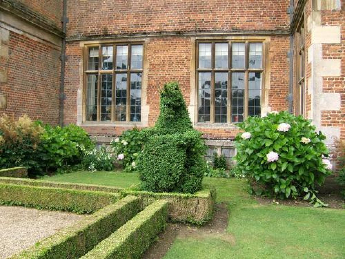
Gardens lie to the east, west, and north of the Hall. The East Garden lies between the Gatehouse and the east front of the Hall, connected by a central gravel path which opens out east of the Hall steps. This gravel area is edged with box with topiary figures at each corner. Magnolia grandiflora trees are planted on either side of the Gatehouse. Lawns lie adjacent to the central path with further paths to north and south edged with box. Conical clipped yews are planted beyond the box-edged paths. This area is shown on the Kip engraving of 1705 with a central path flanked by lawns (Kip and Knyff 1707). In 1872 the courtyard still had a central path but by this date it was flanked by symmetrical curved paths on either side (Parish map, 1872). Large cedars shown growing in the courtyard as high as the roof of the Hall in an aerial photograph of the 1930s were removed along with the circular late Victorian carriage drive in the 1970s (Leach 1991).
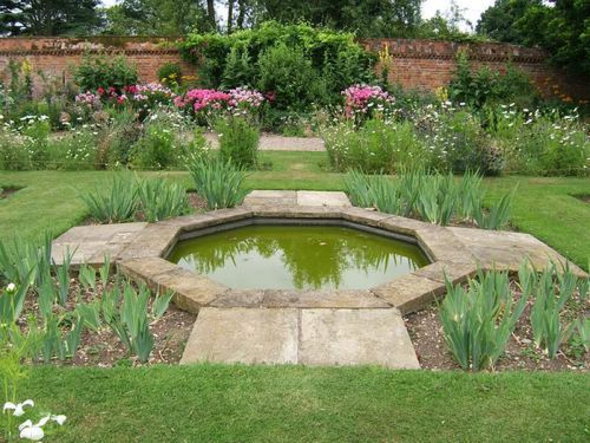
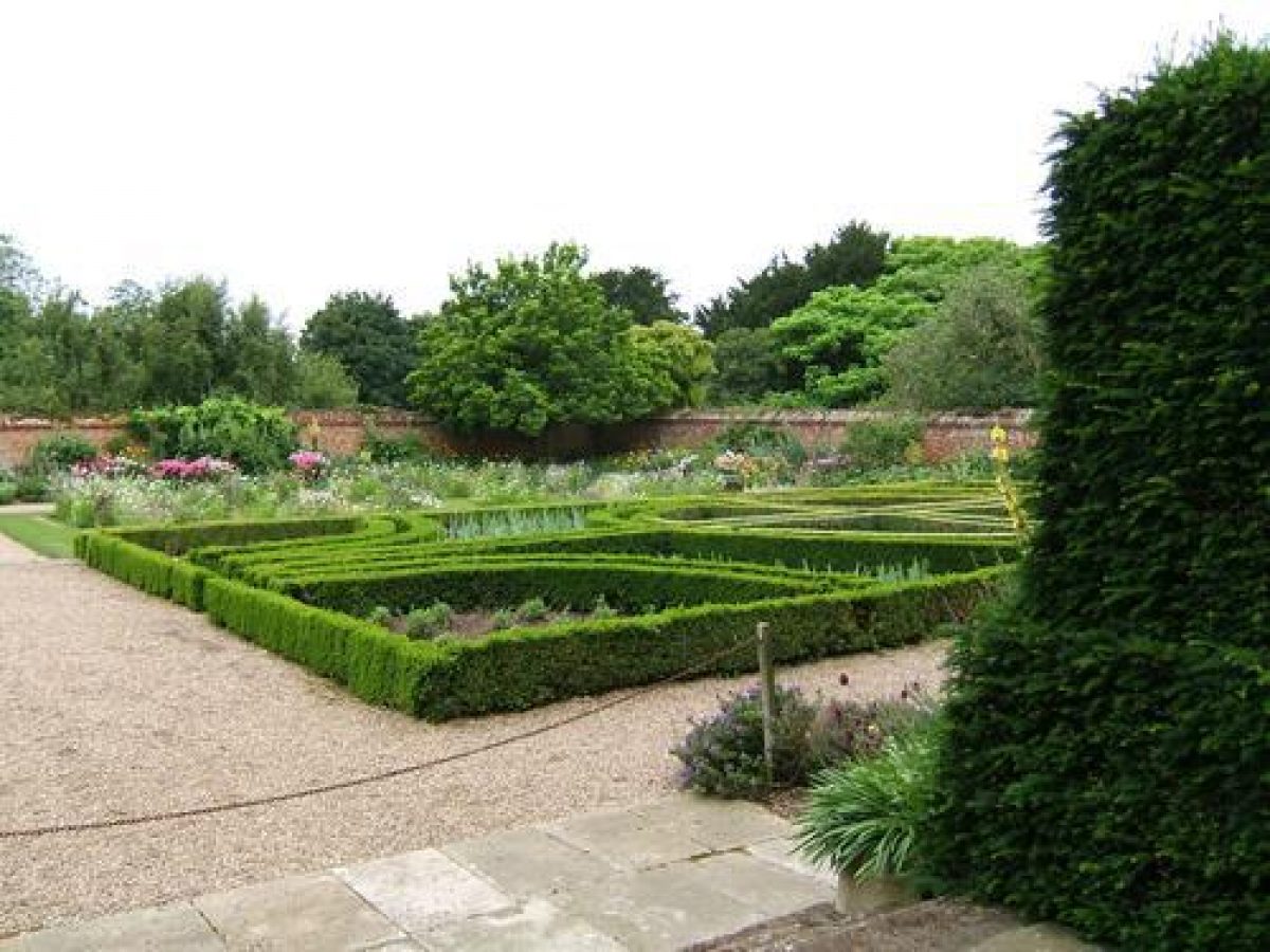
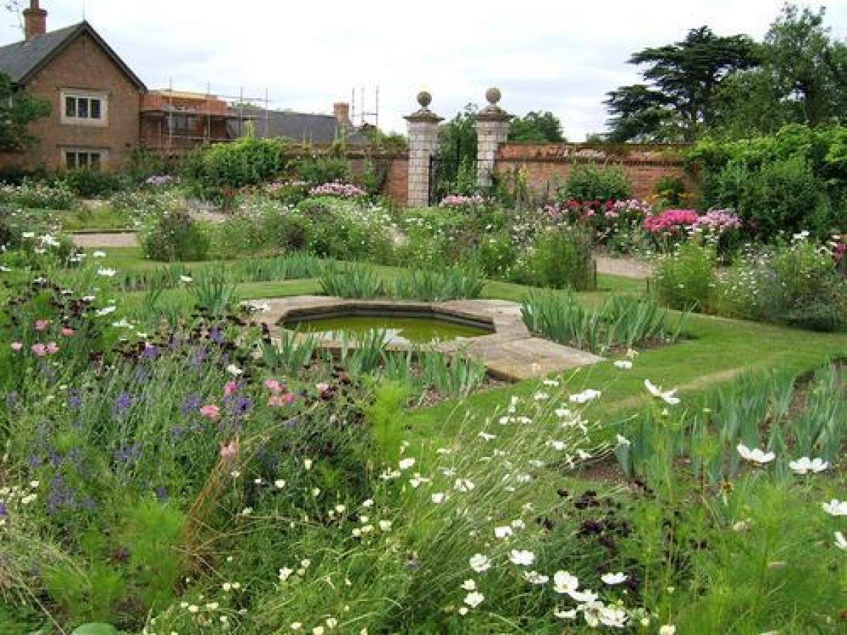
The brick-walled West Garden (garden walls C16, listed grade II*) lies to the west of the Hall. An upper terrace lies immediately west of the Hall with flower beds abutting the walls. Narrow grass borders lie on either side of a paved path which runs north/south. Wooden balustrading constructed in the late C20 (A Jarvis pers comm, 2000) marks the western edge of the upper terrace. An axial paved path leads from a door in the west front of the Hall to a short flight of steps down to the middle terrace. The middle terrace is laid out on either side of the axial path as a box-edged parterre with a path running north/south along its western edge. The axial path continues down a flight of three steps to the lower terrace laid out on either side of the path as a grass parterre, each with a central octagonal pond. Paths to the north and south of the middle terrace also lead to steps to the lower terrace. The axial path continues to an ironwork gate, flanked by gate piers with ball finials (listed grade II*), set into the west wall of the garden.
By 1797 a drawing by C Nattes for Sir Joseph Banks shows the west front of the Hall softened by planting and an axial path leading westwards from the front steps (Leach 1991). On the parish map of 1872 the West Garden is shown as again divided into quarters. In 1900 William Goldring laid out the garden as a formal design of box-edged beds surrounded by herbaceous borders; by the 1950s roses and shrubs had been added (ibid).
Beyond the gateway from the West Garden, the axial path continues westwards as a grass path flanked by an avenue of Irish yews planted in the late 1950s (The Garden 1984). To the south-east of the avenue is a swimming pool and adjacent tennis court. To the north of the avenue are planted some fruit trees. The path continues across a grass path running north/south, and a stream which runs southwards, to a wooden boundary fence marking the edge of the parkland. This area was the site of a further parterre garden of symmetrical ovals as illustrated by Kip in 1705 (Kip and Knyff 1707). It is now (2000) part of the Wild Garden which lies north and west of the West Garden.
From the north gate from the West Garden, immediately north of the Hall, a gravel path leads eastwards, along the north front of the Hall. To the north of the path is the croquet lawn and there are views beyond to a group of sweet chestnuts. The path continues northwards as the Long Walk, with a low wooden trellis between the path and the croquet lawn. The western boundary of the croquet lawn, parallel to Long Walk, is a low brick wall abutted by a beech hedge. The path continues down a short flight of steps, adjacent to the eastern wall which is the boundary between the Kitchen Garden and the Wild Garden. The area between the wall and the path is grassed and planted with small trees. Some 50m from the steps on the east side of the path is a trellis arbour in which stands a semicircular stone bench with lions at either end. Midway along the eastern wall is a doorway into the Kitchen Garden. The path continues northwards to the northern boundary of the garden and the woodland from where there are views out over the parkland. At the end of Long Walk, the path, now grass, turns westwards and midway along it a vase in a low walled alcove acts as an eyecatcher when viewed from south of the croquet lawn.
A temple designed by Anthony Jarvis in 1973 stands 180m north-west of the Hall. From the temple the path divides to lead on either side of the stream which runs north/south 110m west of the Hall. A short distance from the temple among yew trees is a wooden bridge over the stream approached by stone steps. The path west of the stream continues to the west gate into the parkland. The path east of the stream joins the grass path at the western end of the yew avenue. Some 30m north of the yew avenue is a turf maze laid out in the 1980s (Leach 1991). There are views out over the parkland from the Wild Garden. The Wild Garden occupies former orchards illustrated in the Kip view of 1705 (Kip and Knyff 1707).
A lake of c 0.5ha set in its own pleasure grounds is situated 300m south-west of the Hall. This is now (2000) approached by a track from the parkland west of the West Garden. A path shaded by oaks and limes leads around the pond and on the east bank there is a boathouse of brick with a pantile roof. A punt house, roofed with pantiles, stands in the water a few metres to the north. The lake, boathouse, and its accompanying pleasure ground were laid out for Edward Deleval c 1811 (Leach 1991). The punt house was built in the late C20 (A Jarvis pers comm, 2000).
PARK
Parkland lies to the north, west, and south-west of the Hall. A shelter belt north of the temple and the Wild Garden now (2000) contains a woodland walk which starts in the north-west corner of the West Garden and leads north then west. There is a perimeter plantation on the west boundary. A lime avenue has been planted extending across the west park on an axis with the Hall and the west gate of the West Garden. The lime avenue, which replaces a poplar avenue planted in early C20, follows the line of the avenue which is shown on the Kip engraving but was never planted. The majority of the park is under the plough.
The Kip view of 1705 (Kip and Knyff 1707) shows the boundaries of the park marked by shelter belts and hedges and parkland on either side of an avenue running west of the Hall. By 1749 the park north-west of the avenue had become fields known as Lawn and Lawn Paddock and that to the south-west of the avenue was known as the Ineroft Lands (Survey, 1749). Sir John Deleval planted much woodland from the 1760s onwards but the majority of this was cut down in 1808 shortly before his death (CL 1936). The fields remained through the mid and into the late C19 with the addition of a shelter belt running northwards along the western boundary of the garden and continuing north then westwards as the northern boundary of Lawn field (Parish map, 1872).
KITCHEN GARDEN
The walled kitchen garden, which is divided into two, lies north-east of the Hall and is approached from a gate immediately north-east of the Hall. A gate leads into the smaller part of the garden which has lean-to C20 glasshouses on the dividing wall. The larger part is divided by a line of espaliered fruit trees. A gravel path leads from the gate to a pond with a grass edge. Outbuildings stand against this side of the dividing wall. The Kip view of 1705 (Kip and Knyff 1707) shows a walled garden on the site of the present (2000) kitchen garden. This early C18 garden was quartered and had an edging of fruit trees. Five smaller gardens are shown north of the walled garden. By 1872 the kitchen garden had extended northwards and a pond lay to the centre of the garden with glasshouses to the west of this.
REFERENCES
J Kip and L Knyff, Britannia Illustrata (1707)
Country Life, 10 (10 August 1901), p 176; 80 (3 October 1936), p 356; (10 October 1936), p 382
R Dutton, The English Garden (1945), plate 51
J Anthony, The Gardens of Britain 6, (1979), pp 71-3
M Girouard, Robert Smythson and the Elizabethan Country House (1983), pp 137-9, plates 76,77, Figure 7
The Garden, (May 1984), pp 173-8
N Pevsner et al, The Buildings of England: Lincolnshire (2nd edition 1989), pp 253-5
T R Leach, Lincolnshire Country Houses and their Families II, (1991), pp 90-7, 110, plates 54-67
H Thorold, Lincolnshire Houses (1999), pp 131-3
Anonymous, Doddington Hall, A guide to the House and the Families that have lived there (no date)
V and A Jarvis, Stories from Doddington Hall (no date)
Maps
A Survey of the Manor and Lordship of Doddington in the County of Lincoln Taken, Anno 1749 (private collection)
Map of the Parish of Doddington, Lincolnshire, the Property of George Knollis Jarvis Esquire, 1872 (private collection)
OS 6" to 1 mile: 2nd edition published 1900
OS 25" to 1 mile: 3rd edition published 1921
Description written: August 2000
Amended: May 2002
Edited: May 2002
- Visitor Access, Directions & Contacts
Telephone
01522 694308Website
https://www.doddingtonhall.comAccess contact details
Opening times vary seasonally. Please see: http://www.doddingtonhall.com/house-opening-times-and-admission.php
Directions
http://www.doddingtonhall.com/visit-us-location.php
Owners
James and Claire Birch
- History
The following is from the Register of Parks and Gardens of Special Historic Interest. For the most up-to-date Register entry, please visit the The National Heritage List for England (NHLE):
www.historicengland.org.uk/listing/the-list
HISTORIC DEVELOPMENT
The Domesday Book records Doddington Hall as the property of the Abbot of Westminster. By the 12th century the manor was owned by the Pigot family. They sold it to Sir Thomas Burgh in 1450 and it was sold in turn to John Savile (died 1630) of Howley, Leeds. In 1593, he sold the manor house to Thomas Tailor (died 1606) who commissioned Doddington Hall from Robert Smythson. The Hall passed first to Tailor's son, Thomas (died 1652) and then his granddaugher, Elizabeth Anton (1592-1658) who married Sir Edward Hussey of Honington. Their son, Sir Thomas Hussey (1639-1706) inherited in 1658 and was the owner when J Kip made his engraving of Doddington in 1705 (Kip and Knyff 1707). Sir Thomas' three daughters were his co-heiresses when he died in 1706. Mrs Sarah Apreece was the surviving heiress and on her death in 1749, her daughter Rhoda, the wife of Captain Francis Blake Deleval of Seaton Deleval, Northumbria (see description of this site elsewhere in the Register) inherited. Mrs Apreece's will specified that Seaton Deleval and Doddington were not to be in the same ownership. Rhoda Deleval's second son, Sir John Hussey-Deleval lived at Doddington from the time of his marriage in 1750. He inherited the property in about 1760 and made many improvements to the Hall and gardens. When Sir John's elder brother died, he inherited Seaton Deleval but would not pass on Doddington to his younger brother Edward. After legal proceedings Edward Deleval received an annuity and inherited Doddington after his brother's death in 1808. Edward Deleval's daughter, Mrs Gunman, who inherited on her father's death in 1814, left the Hall to Lieutenant Colonel George Jarvis in 1829. In 1899 William Goldring (1854-1919) of Kew, landscape gardener, was commissioned by George Eden Jarvis (1840-1919) to design the west garden (Pevsner et al 1989) which was created in 1900. On Mr Jarvis' death the Hall passed to his cousin the Rev Robert Eden Cole (1831-1921). When he died, his cousin inherited and passed the Hall to his son and then his grandson. In the mid-20th century the Hall was renovated and the gardens redesigned. The Hall and grounds remain (2000) in private ownership.
- Associated People
- Features & Designations
Designations
The National Heritage List for England: Register of Parks and Gardens
- Reference: GD1973
- Grade: II*
Features
- Temple
- Earliest Date:
- Latest Date:
- Turf Maze
- Earliest Date:
- Latest Date:
- House (featured building)
- Earliest Date:
- Latest Date:
- Key Information
Type
Park
Purpose
Ornamental
Principal Building
Domestic / Residential
Survival
Extant
Hectares
32
Open to the public
Yes
Civil Parish
Doddington and
- References
References
- {English Heritage Register of Parks and Gardens of Special Historic Interest}, (Swindon: English Heritage, 2008) [on CD-ROM] Historic England Register of Parks and Gardens of Special Historic Interest
- Anthony, J., {The Gardens of Britain 6: The East Midlands} (London: Batsford, 1979), pp. 71-3 The Gardens of Britain 6: The East Midlands
- Pevsner, N. and J. Harris, {The Buildings of England: Lincolnshire} (London: Penguin, 2nd edition 1989), pp. 253-5 The Buildings of England: Lincolnshire