Introduction
The site originated in the 14th century, with developments in the 16th, 18th and 19th centuries. The park was landscaped by Lancelot Brown in about 1763 and remains generally intact, though the gardens were largely replanted in the 20th century.
Terrain
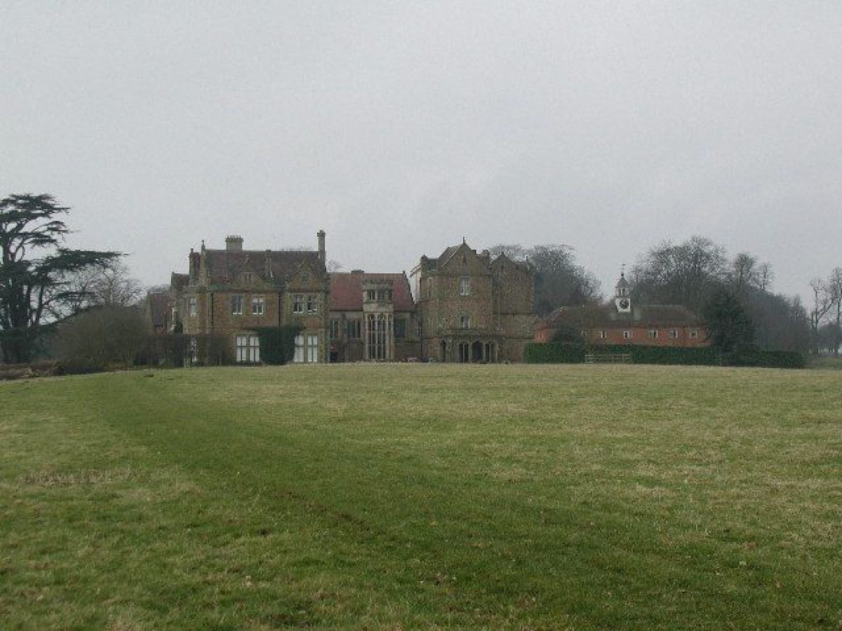
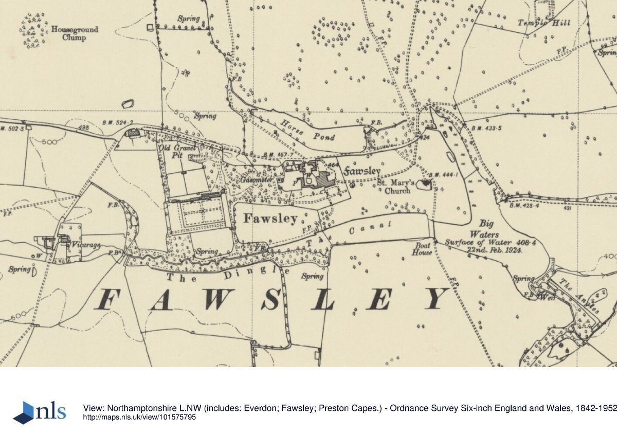
The Hall stands on a relatively low-lying spur, with the main parkland lying on rising ground to the north.www.historicengland.org.uk/listing/the-list
Landscape park, of mid C13 origins and little changed since mid C18, with lakes and C16 lodge, and gardens associated with a country house. Documented involvement by Lancelot Brown.
DESCRIPTION
LOCATION, AREA, BOUNDARIES, LANDFORM, SETTING
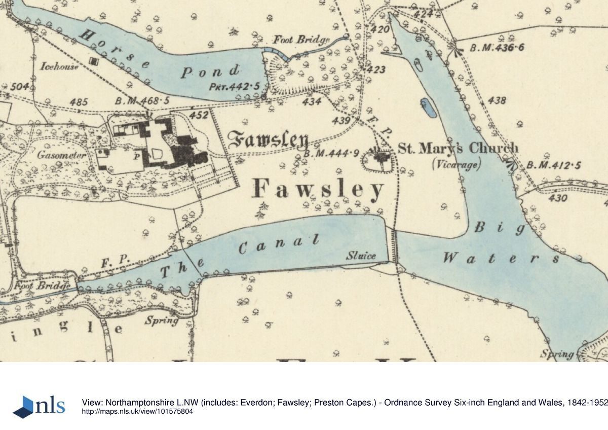
Fawsley Hall lies c 5km south of Daventry, 2km east along a minor road leading off the A361 Daventry to Banbury road. The minor road forms the eastern boundary of the site; otherwise the boundary follows field edges and, to the north, the northern boundary of Badby Wood. The Hall stands on a relatively low-lying spur, with the main parkland lying on rising ground to the north. The area here registered is c 330ha.
ENTRANCES AND APPROACHES
The main approach to the Hall now, as in 1741, is along a minor road which crosses the park from west, off the A361, to east, passing by the north side of the Hall and curving round the northern part of Big Waters. No longer in use is a long drive leading north-west across the park before running up Badby Down to a gate on the A361 5km south-west of Daventry. Here stands the Lantern House (listed grade II), an unusual, two-storey, octagonal ironstone lodge of the late C18 or early C19, small and pepperpot-like. It may be by James Wyatt (d 1813).
PRINCIPAL BUILDING
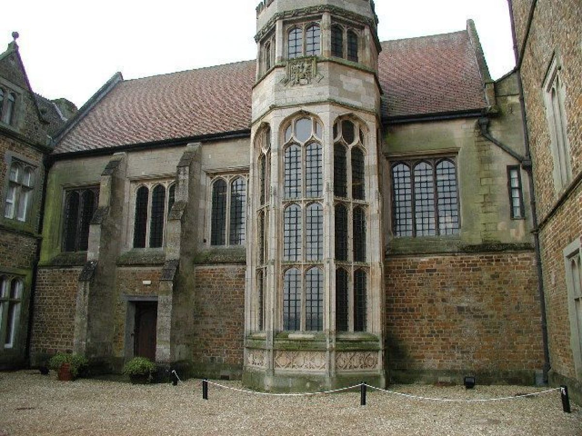
The Hall (listed grade I) is partly of the C16, and partly of 1867(8. It is of coursed, square ironstone, with limestone dressings. Surviving from the house constructed by Richard Knightley (d 1534), or representing additions of only a little later, is a five-bay hall, a south-facing parlour with two-storeyed oriel, the kitchen and bakehouse west of the parlour, and the long range known as the brewhouse (but perhaps originally lodgings) which runs parallel with the hall range, from the bakehouse to the north. The fourth, north side of the inner court is closed by a range dated 1732 and attributed to Francis Smith of Warwick (d 1738) but altered by Thomas Cundy (d 1825) in 1815 and then extended by Anthony Salvin (d 1881) in 1867-8 into a three-storey range.
The Hall was abandoned after 1913, and after the Second World War was used for storage and agricultural industries. Various ancillary buildings were demolished, and in 1966 the Hall's C16 roof was destroyed. In 1975 the Hall was sold, and extensive repairs and restoration began. It opened as a hotel in 1998.
North of the Hall is an early C18 U-plan red-brick stables court (listed grade II) attributed to Francis Smith. The piers of the main gate against the north-east corner of the stables are late C17 (listed grade II). West of the stables is the C18 Coach House (listed grade II), converted into a house in the C20.
GARDENS AND PLEASURE GROUNDS
The gardens around the Hall were largely replanted in the years before 1998. East of the Hall is the front lawn, with a walk of pleached beech and laburnum along its south side. The lawn is separated from the park to the east by a straight ha-ha, probably C19. One of the main views at Fawsley is from the ha-ha to Fawsley's isolated medieval church (listed grade I) which stands on a slight knoll 300m to the east, and to The Canal and Big Waters which run along the valley bottom slightly to the right (south) of the church. From the front lawn there is also a good view north, to the main parkland. South of the Hall, overhung by a mature cedar, are terraced knot gardens, below and south-east of which is a hard tennis court. West of the Hall is a mature shrubbery.
In 1741, as shown on a map of this date, there was a semicircular enclosure around the east (entrance) side of the Hall. Eastward of this, to and beyond the church, was 'Lawn', apparently much the same as in 1998. West of the Hall's western service buildings, and extending west to the kitchen gardens, was a wood or shrubbery with walks.
PARK
Fawsley Park occupies most of the central and northern parts of the parish. It is separated from the Hall and its grounds by a U-plan arrangement of lakes, open to the west, on the spur of ground within which stand the Hall complex and church. The main lake, Big Waters, curves round east of the church. With good, mature parkland trees along its north-east edge, it bulges to the south-east where the lake is retained by a dam. Below this a straight channel, The Angles, carries away the overflow water. Wildfowl breeding may have been carried on here (RCHM(E) 1981). Big Waters adjoins The Canal, the long, triangular lake south of the Hall. North of the Hall is a corresponding triangular lake, Horse Pond, retained at its east end by a massive dam. The lake east of this, and at a much lower level, which linked up with the west end of Big Waters, is now dry and the area occupied by woodland. The triangular area of parkland, sloping gently uphill south of the Canal and Big Waters, contains very few parkland trees, and probably represents a C19 addition to the park. In 1741 it was called Barley Field.
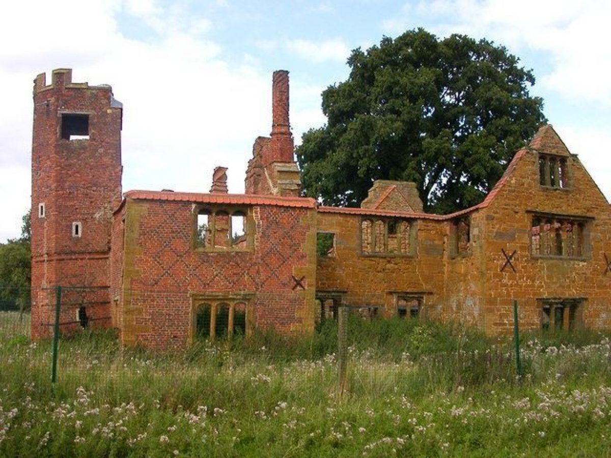
The northern section of the park is occupied by Badby Wood. At the centre of the wood, and forming the focus of radiating rides, is Hazley Knob. Most of the park south of this is permanent pasture with mature parkland trees. Some, especially around the Dower House, are in clumps, and there was a phase of replanting in the 1980s. Ridge and furrow survives under almost all the park's permanent grassland; ploughing last took place between the C15 and C18 (see below). The one main area free of such remains is south of Badby Wood. It is suggested that hereabouts, before imparkment, may have been permanent waste or a rabbit warren (ibid). The Dower House (listed grade II) stands in a slight declivity in the eastern part of this area 1km north-east of the Hall. It was built in the C16 as a hunting lodge and is presumably the lodge referred to in a lease of 1619. It is a small, H-plan house in brick and ironstone, the former being used, with diaper decoration, in a polygonal tower attached to the earlier front range. This may represent the first example of the use of brick in the county. The slight earthworks around the house may be the remains of a small formal garden (ibid). At least one pillow mound has been identified nearby. About 100m north-west of the Dower House are low, double banks of unknown purpose.
Temple Hill, so known by 1741, rises in the eastern part of the park. No structure however is shown here on a map of that date although post-medieval roofing tiles have been found within an earthwork enclosure on top of the hill. This enclosure is roughly aligned on, and 200m east of, an avenue of oaks which runs east/west across the park 500m north of the Hall. That avenue (present 1741) was partly replanted in the 1980s. About 300m south of Temple Hill a substantial bank and ditch with veteran oaks runs east from the north end of Big Waters past the north end of Nursery wood. It carries on the line of Horse Pond and probably represents an early, certainly pre-1741 and perhaps C16, park boundary.
Badby Wood was imparked in 1245-6 by charter granted to the abbot of Evesham who had a grange at Badby, the adjoining parish to the north. Assarting may have taken place in the Middle Ages. Documentary evidence suggests that in the early C15 Richard Knightley was engaged on a deliberate policy of eviction at Fawsley in order to turn the parish over to sheep farming, and in 1442 Badby Wood and park totalled nearly 700 acres (c 290ha). In 1547 2500 sheep were kept here. The poaching of a deer in Fawsley park is recorded in the early C16. The park centred on Badby Wood was apparently incorporated within a new one created in Elizabeth's reign, presumably associated with which was the construction of the Dower House. In the early C18 only six houses were recorded in the parish of which four were 'dispersed in the fields' (Bridges 1791, cited by RCHM(E) 1981). By the time Fawsley was mapped in 1741 the park was much as it was in 1998. The village had entirely disappeared, and Horse Pond, Big Waters and The Canal were all established. In the park north of Horse Pond, between it and Badby Wood, there were three main avenues, all straight. A double one, providing the main route from the Hall to the Dower House, ran north-east, from the north-east edge of Horse Pond to the south-east corner of Badby Wood. Two single avenues ran across this: that which still survives, and another to its north. A fourth, minor avenue north-east of the Dower House connected with the radiating rides in Badby Wood. In 1763 Lancelot Brown (1716-83) was reported to be 'laying out [the ground] and making a large piece of water' (Stroud 1975, 177, 225). As all the lakes were already established it is difficult to assess what this refers to; the one possibility suggested by map evidence is that the western half of The Canal may have been broadened. Brown also spent a night at Fawsley in 1775.
KITCHEN GARDEN
The brick-walled kitchen gardens lie 300m west of the Hall. They were already located here in 1741. The main rectangular compartment is c 120m east/west and 70m north/south, and slopes markedly downhill from north to south. The interior was overgrown in 1998, and only the iron frame of a vinery remained against the west half of the north wall. The central door on the north side leads into a small, brick, hip-roofed gardener's house; probably, like the garden walls, this is mid C18.To either side there are brick sheds of the C18 and C19. Those to the west of the house are ruinous, while those to the east retain their slate roofs and are in good condition. Outside the north-east corner of the garden is a one-and-a-half storey stone gardener's house of the mid C19.
REFERENCES
Country Life, 24 (4 July 1908), pp 18-27
N Pevsner and B Cherry, The Buildings of England: Northamptonshire (1973), pp 214-16
D Stroud, Capability Brown (1975)
Roy Comm Hist Mons Engl Inventories: Northamptonshire 3, (1981), pp 88-91
Medieval Settlement Research Group Annual Report 6, (1991), pp 19-20
J Heward and R Taylor, The Country Houses of Northamptonshire, (RCHM(E) 1996), pp 211-22
Phibbs, J, ‘Fawsley Hall, Northamptonshire. The tercentenary of Lancelot 'Capability' Brown (1716-1783)'. Unpub report (April 2016).
Maps
Fawsley estate map, 1741 (Map 853), (Northants Record Office)
Archival items
Northamptonshire Heritage Sites and Monuments Record entries.
Description written: July 1998
Register Inspector: PAS
Edited: January 2000
- Visitor Access, Directions & Contacts
Access contact details
Hotel guests only. 01327 892000
Directions
On the A361 between Daventry and Banbury
- History
The following is from the Register of Parks and Gardens of Special Historic Interest. For the most up-to-date Register entry, please visit the The National Heritage List for England (NHLE):
www.historicengland.org.uk/listing/the-list
HISTORIC DEVELOPMENT
The manor of Fawsley was bought in 1416 by Richard Knightley, a successful Staffordshire lawyer. It remained in the hands of that family until the 1930s. The present house was begun by Richard's grandson, also Richard (d 1534), who married a wealthy Northamptonshire heiress. Sir Richard Knightley (d 1615), who inherited in 1566, entertained the Queen at Fawsley in 1575. After a century of long minorities and premature deaths Lucy Knightley (d 1738), who inherited in 1728, began building again in 1732. The family represented the county in Parliament throughout the C18, and in 1798 Sir John (d 1812) was created baronet. The accounts of Lancelot Brown (1716-83) suggest that he may first have been working at Fawsley in 1756 and when Horace Walpole visited in 1763 he found Brown ‘laying out' and ‘making a large piece of water'. In 1765-6 Brown had a contract for £700 and in 1767-8 a second contract for £550.
Building continued under Sir John's nephew Sir Charles (d 1864) and the latter's son Rainald (d 1895). The house was unoccupied after 1913, and the contents were sold in 1914. The last baronet, Rev Henry Francis Knightley, died in 1938 and the house passed to the sixth Viscount Gage. The house and the former park remain (1998) in private ownership.
- Associated People
- Features & Designations
Designations
The National Heritage List for England: Register of Parks and Gardens
- Reference: GD2035
- Grade: II*
Style
English Landscape Garden
Features
- Ha-ha
- Lake
- Knot Garden
- Lawn
- Pleached Trees
- Specimen Tree
- House (featured building)
- Now Hotel
- Latest Date:
- Key Information
Type
Park
Purpose
Ornamental
Principal Building
Commercial
Survival
Extant
Hectares
330
Open to the public
Yes
Civil Parish
Fawsley
- References
References
- {English Heritage Register of Parks and Gardens of Special Historic Interest}, (Swindon: English Heritage, 2008) [on CD-ROM] Historic England Register of Parks and Gardens of Special Historic Interest
- Stroud, D., {Capability Brown} (London: Faber, 1975) Capability Brown
- Pevsner, N. and B. Cherry, {The Buildings of England: Northamptonshire} (Harmondsworth: Penguin, 1973), pp. 214-6 The Buildings of England: Northamptonshire